212.42.99.135 - IP Lookup: Free IP Address Lookup, Postal Code Lookup, IP Location Lookup, IP ASN, Public IP
Country:
 Kyrgyzstan
Region:
City:
Location:
Time Zone:
Postal Code:
ISP:
ASN:
language:
User-Agent:
Proxy IP:
Blacklist:
IP information under different IP Channel
ip-api
Country
Region
City
ASN
Time Zone
ISP
Blacklist
Proxy
Latitude
Longitude
Postal
Route
db-ip
Country
Region
City
ASN
Time Zone
ISP
Blacklist
Proxy
Latitude
Longitude
Postal
Route
IPinfo
Country
Region
City
ASN
Time Zone
ISP
Blacklist
Proxy
Latitude
Longitude
Postal
Route
IP2Location
212.42.99.135Country
kgRegion
jalal-abad
City
tash-kumyr
Time Zone
Asia/Bishkek
ISP
Language
User-Agent
Latitude
Longitude
Postal
ipdata
Country
Region
City
ASN
Time Zone
ISP
Blacklist
Proxy
Latitude
Longitude
Postal
Route
Popular places and events near this IP address

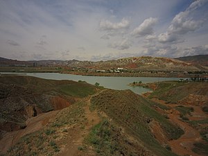
Tash-Kömür
Place in Jalal-Abad Region, Kyrgyzstan
Distance: Approx. 436 meters
Latitude and longitude: 41.35,72.21666667
Tash-Kömür (Kyrgyz: Таш-Көмүр, Russian: Таш-Кумыр Tash-Kumyr) is one of the five largest towns of Jalal-Abad Region in Southern Kyrgyzstan. It is a city of regional significance, not part of a district. Its area is 47 square kilometres (18 sq mi), and its resident population was 44,065 in 2021.

Sary-Kamysh, Jalal-Abad
Place in Jalal-Abad Region, Kyrgyzstan
Distance: Approx. 4276 meters
Latitude and longitude: 41.33055556,72.26388889
Sary-Kamysh is a village in Jalal-Abad Region of Kyrgyzstan, near the town Tashkömür. It is part of Nooken District. Its population was 48 in 2021.
Shamaldy-Say Hydroelectric Power Station
Distance: Approx. 4406 meters
Latitude and longitude: 41.31166667,72.19111111
The Shamaldy-Say Hydro Power Plant (Kyrgyz: Шамалды-Сай ГЭСи, Russian: Шамалды-Сайская ГЭС) is an active hydro power plant on the river Naryn between Tash-Kömür and Shamaldy-Say, in Kyrgyzstan. Completed between 1992 and 1996, it is one of the three hydro power plants on the river Naryn near Tash-Kömür, 14 km downstream from the Tash-Kömür Hydroelectric Power Station. It has 3 individual turbines with a nominal output of around 80 MW and a total nominal capacity of 180 MW. The power plant's dam is 37 m (121 ft) tall and creates a 41,000,000 m3 (33,239 acre⋅ft) reservoir of which 5,500,000 m3 (4,459 acre⋅ft) is active (or useful) for power generation.
Tash-Kömür Hydroelectric Power Station
Kyrgyzstani hydroelectric power plant
Distance: Approx. 6521 meters
Latitude and longitude: 41.40361111,72.23194444
The Tash-Kömür Hydro Power Plant (Kyrgyz: Таш-Көмүр ГЭСи, Russian: Таш-Кумырская ГЭС) is a hydroelectric power plant on the river Naryn in Tash-Kömür, Kyrgyzstan. Completed between 1985 and 1987, it is one of three hydro power plants on the river Naryn near Tash-Kömür, 14 km upstream from the Shamaldy-Say Hydroelectric Power Station. It has 3 individual turbines with a nominal output of around 150 MW and a total nominal capacity of 450 MW. The power plant's dam is 75 m (246 ft) tall, creating a 140,000,000 m3 (113,500 acre⋅ft) reservoir of which 10,000,000 m3 (8,107 acre⋅ft) is active (or useful) for power generation.
Kara-Suu (Aksy)
River in Kyrgyzstan
Distance: Approx. 6812 meters
Latitude and longitude: 41.40694444,72.22583333
The Kara-Suu (Kyrgyz: Кара-Суу) or (Kyrgyz: Карасуу) is a right tributary of the Naryn in Aksy District, Jalal-Abad Region, Kyrgyzstan. The river originates in the Chatkal Range, western Tian Shan mountains. It flows through the villages Chaldybar and Jangy-Jol.
Weather in this IP's area
overcast clouds
4 Celsius
4 Celsius
4 Celsius
4 Celsius
1023 hPa
62 %
1023 hPa
913 hPa
10000 meters
0.61 m/s
0.94 m/s
90 degree
100 %