Country:
 Russian Federation
Region:
City:
Latitude and Longitude:
Time Zone:
Postal Code:
IP information under different IP Channel
ip-api
Country
Region
City
ASN
Time Zone
ISP
Blacklist
Proxy
Latitude
Longitude
Postal
Route
IPinfo
Country
Region
City
ASN
Time Zone
ISP
Blacklist
Proxy
Latitude
Longitude
Postal
Route
MaxMind
Country
Region
City
ASN
Time Zone
ISP
Blacklist
Proxy
Latitude
Longitude
Postal
Route
Luminati
Country
RURegion
vgg
City
volgograd
ASN
Time Zone
Europe/Volgograd
ISP
LUKOIL Technology Services GmbH
Latitude
Longitude
Postal
db-ip
Country
Region
City
ASN
Time Zone
ISP
Blacklist
Proxy
Latitude
Longitude
Postal
Route
ipdata
Country
Region
City
ASN
Time Zone
ISP
Blacklist
Proxy
Latitude
Longitude
Postal
Route
Popular places and events near this IP address
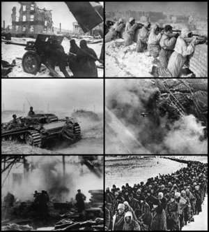
Battle of Stalingrad
1942–1943; major battle of World War II
Distance: Approx. 2105 meters
Latitude and longitude: 48.7,44.51666667
The Battle of Stalingrad (17 July 1942 – 2 February 1943) was a major battle on the Eastern Front of World War II, beginning when Nazi Germany and its Axis allies attacked and became locked in a protracted struggle with the Soviet Union for control over the Soviet city of Stalingrad in southern Russia. The battle was characterized by fierce close-quarters combat and direct assaults on civilians in aerial raids; the battle epitomized urban warfare, being the single largest and costliest urban battle in military history. It was the bloodiest and fiercest battle of the entirety of World War II—and arguably in all of human history—as both sides suffered tremendous casualties amidst ferocious fighting in and around the city.

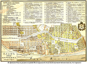
Volgograd
City in Volgograd Oblast, Russia
Distance: Approx. 1229 meters
Latitude and longitude: 48.70861111,44.51472222
Volgograd (Russian: Волгоград, IPA: [vəɫɡɐˈɡrat] ), formerly Tsaritsyn (Царицын; IPA: [tsɐˈrʲitsɨn]) (1589–1925) and Stalingrad (Сталинград; IPA: [stəlʲɪnˈɡrat] ) (1925–1961), is the largest city and the administrative centre of Volgograd Oblast, Russia. The city lies on the western bank of the Volga, covering an area of 859.4 square kilometres (331.8 square miles), with a population of slightly over one million residents. Volgograd is the 16th-largest city by population size in Russia, the second-largest city of the Southern Federal District, and the fourth-largest city on the Volga.
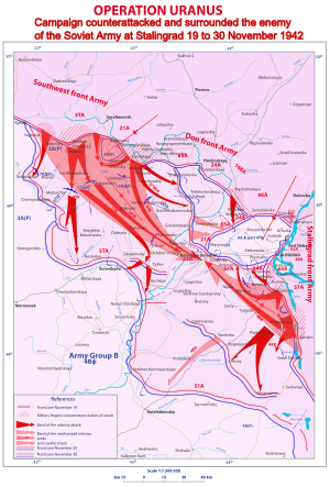
Operation Uranus
1942 Soviet strategic operation in World War II
Distance: Approx. 2105 meters
Latitude and longitude: 48.7,44.51666667
Operation Uranus (Russian: Опера́ция «Ура́н», romanized: Operatsiya "Uran") was a Soviet 19–23 November 1942 strategic operation on the Eastern Front of World War II which led to the encirclement of Axis forces in the vicinity of Stalingrad: the German Sixth Army, the Third and Fourth Romanian armies, and portions of the German Fourth Panzer Army. The Red Army carried out the operation at roughly the midpoint of the five-month long Battle of Stalingrad, aiming to destroy German forces in and around Stalingrad. Planning for Operation Uranus had commenced in September 1942, and developed simultaneously with plans to envelop and destroy German Army Group Center (Operation Mars) and German forces in the Caucasus.

Pavlov's House
Battle of Stalingrad strategic location
Distance: Approx. 2058 meters
Latitude and longitude: 48.716,44.5315
Pavlov's House (Russian: дом Павлова tr. Dom Pavlova) was an apartment building converted into a fortified position, which Red Army defenders held for around 60 days against the Wehrmacht offensive during the Battle of Stalingrad. The siege lasted from 27 September to 25 November 1942 and eventually the Red Army managed to relieve it from the siege.
Volgograd State Pedagogical University
Distance: Approx. 1697 meters
Latitude and longitude: 48.71472222,44.52638889
The Volgograd State Pedagogical University (Russian: Волгоградский государственный педагогический университет, abbreviation: VSPU) is one of the major pedagogical institutions in the Russian Federation. The university is located in Volgograd, formerly known as Stalingrad (Russia).
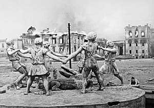
Barmaley Fountain
Fountain in Volgograd, Russia
Distance: Approx. 876 meters
Latitude and longitude: 48.712498,44.513486
The Barmaley (Russian: Бармалей) is an informal name of a fountain in the city of Volgograd (formerly known as Stalingrad). Its official name is Children's Khorovod (Round Dance). The statue is of a circle of six children dancing the khorovod around a crocodile.

Volgograd State Medical University
Russian Medical University
Distance: Approx. 1385 meters
Latitude and longitude: 48.70694444,44.515
Volgograd State Medical University is located in Volgograd which is situated in the southern part of Russia on the west bank of the Volga River. It started as Stalingrad Medical Institute founded in 1935. In 1993 it received the status of the Academy, and in 2003 it was granted the status of the University.

December 2013 Volgograd bombings
Two suicide bombings in the city of Volgograd, Volgograd Oblast, Southern Russia
Distance: Approx. 876 meters
Latitude and longitude: 48.712498,44.513486
In December 2013, two separate suicide bombings a day apart targeted mass transportation in the city of Volgograd, in the Volgograd Oblast of Southern Russia, killing 34 people overall, including both perpetrators. The attacks followed a bus bombing carried out in the same city two months earlier.

Volgograd railway station
Major railway station in Volgograd, Volgograd Oblast, Russia
Distance: Approx. 884 meters
Latitude and longitude: 48.7125,44.51361111
Volgograd-Glavny (Russian: Волгоград-Главный) is a major junction railway station of Volgograd in Russia. It is located in the Central District of the city at Railway Station Square, 1. The station is one of the largest in Russia and serves long-distance trains and suburban trains.
Battle of Tsaritsyn
Part of the Southern Front of the Russian Civil War
Distance: Approx. 2105 meters
Latitude and longitude: 48.7,44.51666667
The Battle of Tsaritsyn was a military confrontation between the Red Army and the White Army during the Russian Civil War for control of Tsaritsyn (now Volgograd), a significant city and port on the Volga River in southwestern Russia. The city, which had been an important center of support for the October Revolution and remained in the hands of the Reds, was besieged three times by anti-Bolshevik Don Cossacks under the command of Pyotr Krasnov: July–September 1918, September–October 1918, and January–February 1919. Another attempt to conquer Tsaritsyn was made in May–June 1919 by the Volunteer Army, which successfully captured the city.

St. Nicholas' Church, Volgograd
Church in Volgograd, Russia
Distance: Approx. 1949 meters
Latitude and longitude: 48.7206,44.5294
St. Nicholas' Church (Russian: Храм Святого Николая) is a parish of the Roman Catholic Church in the city of Volgograd, within the Diocese of St. Clement at Saratov in Russia.

Volgograd Conservatory
Distance: Approx. 1229 meters
Latitude and longitude: 48.7071,44.5115
State Budgetary Educational Institution of Higher Education "Volgograd State Conservatory named after P. A. Serebryakov" is one of the Russian conservatories, a higher educational institution of arts in the city of Volgograd. It is named after the Soviet pianist Pavel Serebryakov.
Weather in this IP's area
clear sky
26 Celsius
25 Celsius
26 Celsius
26 Celsius
1023 hPa
22 %
1023 hPa
1016 hPa
10000 meters
6 m/s
130 degree
05:29:09
18:30:26