212.3.9.94 - IP Lookup: Free IP Address Lookup, Postal Code Lookup, IP Location Lookup, IP ASN, Public IP
Country:
 Sweden
Region:
City:
Location:
Time Zone:
Postal Code:
ISP:
ASN:
language:
User-Agent:
Proxy IP:
Blacklist:
IP information under different IP Channel
ip-api
Country
Region
City
ASN
Time Zone
ISP
Blacklist
Proxy
Latitude
Longitude
Postal
Route
db-ip
Country
Region
City
ASN
Time Zone
ISP
Blacklist
Proxy
Latitude
Longitude
Postal
Route
IPinfo
Country
Region
City
ASN
Time Zone
ISP
Blacklist
Proxy
Latitude
Longitude
Postal
Route
IP2Location
212.3.9.94Country
seRegion
vastra gotalands lan
City
uddevalla
Time Zone
Europe/Stockholm
ISP
Language
User-Agent
Latitude
Longitude
Postal
ipdata
Country
Region
City
ASN
Time Zone
ISP
Blacklist
Proxy
Latitude
Longitude
Postal
Route
Popular places and events near this IP address

Uddevalla Municipality
Municipality in Västra Götaland County, Sweden
Distance: Approx. 1523 meters
Latitude and longitude: 58.35,11.91666667
Uddevalla Municipality (Swedish: Uddevalla kommun) is a municipality in Västra Götaland County in western Sweden. Its seat is located in the city of Uddevalla. The present municipality was created in 1971 when the City of Uddevalla (which had absorbed the rural municipality Bäve in 1945) was amalgamated with the surrounding municipalities Forshälla, Lane-Ryr, Ljungskile, Skredsvik and parts of Skaftö.
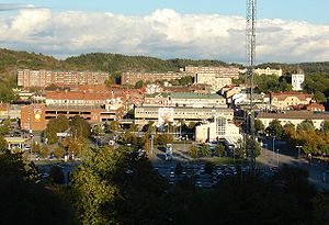
Uddevalla
Place in Bohuslän, Sweden
Distance: Approx. 296 meters
Latitude and longitude: 58.34916667,11.93805556
Uddevalla is a town and the seat of Uddevalla Municipality in Västra Götaland County, Sweden. In 2015, it had a population of 34,781. It is located at a bay of the south-eastern part of Skagerrak.

Rimnersvallen
Sports venue in Uddevalla, Sweden
Distance: Approx. 1082 meters
Latitude and longitude: 58.35666667,11.95
Rimnersvallen is a multi-use stadium in Uddevalla, Sweden. It is currently used mostly for football matches. The stadium holds 10,605 people.

Agnebergshallen
Distance: Approx. 75 meters
Latitude and longitude: 58.34722222,11.94305556
Agnebergshallen is an indoor arena for sports events and concerts in Uddevalla, Sweden. The arena, which was inaugurated in 1987, has a capacity for 2.400 during sports events. It is the home arena of both the man and woman section of the handball club Kroppskultur (Kroppskultur Herr, Kroppskultur Dam).
Allianshallen
Distance: Approx. 75 meters
Latitude and longitude: 58.34722222,11.94305556
Allianshallen is an indoor arena in Uppsala, Sweden, used mostly for floorball. It is the home arena of FBC Uppsala and of the women's team of IK Sirius IBK, while the men's team use Fyrishov as their home arena. Allianshallen has been used as an indoor arena since January 1999, in a building which was formerly owned by publisher Almqvist & Wiksell.

Bohuslän Regiment
Military unit
Distance: Approx. 866 meters
Latitude and longitude: 58.34777778,11.95722222
The Bohuslän Regiment (Swedish: Bohusläns regemente), designation I 17, was a Swedish Army infantry regiment that traces its origins back 1661. It was disbanded in 1992. The regiment's soldiers were originally recruited from the provinces of Bohuslän, and it was later garrisoned there in the town Uddevalla.

Bäveån
River in Sweden
Distance: Approx. 1523 meters
Latitude and longitude: 58.35,11.91666667
Bäveån is a river in Sweden. It is nearby Skansberget, Brattåsholmen and Lövåsberget.

Tureborg Castle
Distance: Approx. 1011 meters
Latitude and longitude: 58.3405,11.9527
Tureborg Castle is a faux-medieval castle located in Uddevalla Municipality, Sweden, it sits atop a hill overlooking the neighbourhood of Tureborg . It was constructed during the late 19th century and early 20th century. Today a ruin after a fire in the 1950s, the castle remains a prominent landmark in Uddevalla.
Ture Valleys
Place in Bohuslän, Sweden
Distance: Approx. 1324 meters
Latitude and longitude: 58.341,11.961
Ture Valleys or Ture's Valleys (Swedish: Ture dalar and Tures dalar) is a nature reserve in the town of Uddevalla, Sweden. Located by the foot of the mountain Fjällsätern, on which Tureborg Castle stands, close to the Tureborg district, the area is named for Ture Malmgren (1851–1922), a prominent, wealthy and highly eccentric local politician and newspaper owner, once chairman of the Uddevalla city council and founder of Bohusläningen. Originally proposed in 1979, a plan to survey the area was put in place in 1988, and the nature reserve was finally created in 1991.

Fjällsätern
Distance: Approx. 978 meters
Latitude and longitude: 58.341,11.953
Fjällsätern is a minor mountain in southern Uddevalla, Sweden. Its summit reaches 105.9 metres (347 ft) above sea level according to one 1950 estimate (an earlier one from 1903 put it at 300 Swedish feet), making it the area's second highest. There the local politician and publicist Ture Malmgren (1851–1922) began building his grand Tureborg Castle, today a ruin, in 1899.

Tureholm (island)
Distance: Approx. 711 meters
Latitude and longitude: 58.3453,11.9536
Tureholm is a small and uninhabited artificial river island in Bäveån, which runs through the city of Uddevalla in Bohuslän, Sweden. It was created in the late 19th century or early 20th century by the local politician and publicist Ture Malmgren (1851–1922), close to his residence Villa Elfkullen. According to his newspaper Bohusläningen (writing many years after he died), the process of land reclamation took place because Malmgren enjoyed water, and wanted to be closer to the river.

Museum of Bohuslän
Museum in Sweden
Distance: Approx. 869 meters
Latitude and longitude: 58.3493,11.9278
The Museum of Bohuslän is a museum in the Swedish province of Bohuslän, established in Uddevalla in 1863. Elsa Garmann Andersen's collection of Street photography is classified in this museum.
Weather in this IP's area
few clouds
1 Celsius
-3 Celsius
1 Celsius
2 Celsius
1043 hPa
91 %
1043 hPa
1032 hPa
10000 meters
3.53 m/s
9.61 m/s
75 degree
18 %