212.3.35.70 - IP Lookup: Free IP Address Lookup, Postal Code Lookup, IP Location Lookup, IP ASN, Public IP
Country:
Region:
City:
Location:
Time Zone:
Postal Code:
ISP:
ASN:
language:
User-Agent:
Proxy IP:
Blacklist:
IP information under different IP Channel
ip-api
Country
Region
City
ASN
Time Zone
ISP
Blacklist
Proxy
Latitude
Longitude
Postal
Route
db-ip
Country
Region
City
ASN
Time Zone
ISP
Blacklist
Proxy
Latitude
Longitude
Postal
Route
IPinfo
Country
Region
City
ASN
Time Zone
ISP
Blacklist
Proxy
Latitude
Longitude
Postal
Route
IP2Location
212.3.35.70Country
Region
andalucia
City
alhama de granada
Time Zone
Europe/Madrid
ISP
Language
User-Agent
Latitude
Longitude
Postal
ipdata
Country
Region
City
ASN
Time Zone
ISP
Blacklist
Proxy
Latitude
Longitude
Postal
Route
Popular places and events near this IP address

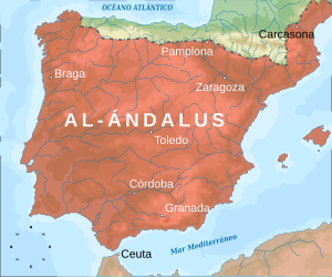
Al-Andalus
Territories of the Iberian Peninsula under Muslim rule (711–1492)
Distance: Approx. 1202 meters
Latitude and longitude: 37,-4
Al-Andalus (Arabic: الأَنْدَلُس, romanized: al-ʾAndalus) was the Muslim-ruled area of the Iberian Peninsula. The name refers to the different Muslim states that controlled these territories at various times between 711 and 1492. At its greatest geographical extent, it occupied most of the peninsula as well as Septimania under Umayyad rule.

Alhama de Granada
Municipality in Andalusia, Spain
Distance: Approx. 949 meters
Latitude and longitude: 37,-3.98333333
Alhama de Granada is a town in the province of Granada, approx. 50 km from the city of Granada. The name is derived from the thermal baths located there, which are called الـحَـمّـة al-hammah in Arabic.

Arenas del Rey
Municipality in Andalusia, Spain
Distance: Approx. 9684 meters
Latitude and longitude: 36.95777778,-3.89972222
Arenas del Rey is a village located in the province of Granada, Spain. According to the 2006 census (INE), the city had a population of 1,231 inhabitants. The village is just north of the Sierras of Tejeda, Almijara and Alhama Natural Park.

Cacín
Place in Granada, Spain
Distance: Approx. 8064 meters
Latitude and longitude: 37.05,-3.91666667
Cacín is a city located in the province of Granada, Spain. It lies to the east of the Río Cacín, from which it takes its name. According to the 2005 census (INE), the city has a population of 697 inhabitants.

Santa Cruz del Comercio
City in Granada, Spain
Distance: Approx. 6223 meters
Latitude and longitude: 37.06166667,-3.97555556
Santa Cruz del Comercio is a municipality located in the province of Granada, Spain. According to the 2005 census (INE), the city has a population of 544 inhabitants. During the Granadin earthquake of 25 December 1884, more than 70% of the houses collapsed and 20% were severely damaged.

Los Bermejales Reservoir
Reservoir in Arenas del Rey
Distance: Approx. 9456 meters
Latitude and longitude: 36.98388889,-3.88722222
Los Bermejales Reservoir (Spanish: Embalse de los Bermejales) is a reservoir in Arenas del Rey, province of Granada, Andalusia, Spain. It is fed by streams from the Sierra de Almijara mountains in the Sierras of Tejeda, Almijara and Alhama Natural Park and is the source of the Cacín River.

1884 Andalusian earthquake
Earthquake in Spain
Distance: Approx. 8853 meters
Latitude and longitude: 36.96,-4.07
The 1884 Andalusian earthquake (Spanish: Terremoto de Andalucía de 1884) occurred on 25 December 1884 at 9:08 p.m in the south of Spain, and had an estimated magnitude of 6.7 Mw. It shook a poor region where many of the houses were built without foundations, with lime or mud mortar, and with weak joints. More than 10,000 buildings were badly damaged, of which 4,399 were completely destroyed.
Weather in this IP's area
overcast clouds
15 Celsius
14 Celsius
12 Celsius
15 Celsius
1021 hPa
67 %
1021 hPa
909 hPa
10000 meters
3.05 m/s
4 m/s
212 degree
100 %