212.3.33.81 - IP Lookup: Free IP Address Lookup, Postal Code Lookup, IP Location Lookup, IP ASN, Public IP
Country:
Region:
City:
Location:
Time Zone:
Postal Code:
ISP:
ASN:
language:
User-Agent:
Proxy IP:
Blacklist:
IP information under different IP Channel
ip-api
Country
Region
City
ASN
Time Zone
ISP
Blacklist
Proxy
Latitude
Longitude
Postal
Route
db-ip
Country
Region
City
ASN
Time Zone
ISP
Blacklist
Proxy
Latitude
Longitude
Postal
Route
IPinfo
Country
Region
City
ASN
Time Zone
ISP
Blacklist
Proxy
Latitude
Longitude
Postal
Route
IP2Location
212.3.33.81Country
Region
andalucia
City
chimeneas
Time Zone
ISP
Language
User-Agent
Latitude
Longitude
Postal
ipdata
Country
Region
City
ASN
Time Zone
ISP
Blacklist
Proxy
Latitude
Longitude
Postal
Route
Popular places and events near this IP address

Federico García Lorca Granada Airport
Airport in Granada
Distance: Approx. 7492 meters
Latitude and longitude: 37.18861111,-3.77722222
Federico García Lorca Granada-Jaén Airport (IATA: GRX, ICAO: LEGR), also known as Granada International Airport, is the airport serving the province and city of Granada, in Andalusia, Spain, although it has Jaén in its name. The airport is located near to Chauchina and Santa Fe, about 9.4 miles (15 km) west of Granada and 62.5 miles (100 km) south of Jaén. Construction of the airport began in 1970 and it opened as Aeropuerto de Granada in 1972.

Láchar
Municipality in Andalusia, Spain
Distance: Approx. 7733 meters
Latitude and longitude: 37.2,-3.83333333
Láchar is a municipality in the province of Granada, in Spain. The village of Láchar lies in Granada's floodplain (or "Vega de Granada", in Spanish) amid poplar forests, arable farmland and olive groves. The surrounding countryside, and particularly the pine forest known as Los Pinares, lends itself to outdoor sports and recreational activities, and there is also a long tradition of partridge shooting.

Chauchina
Municipality in Andalusia, Spain
Distance: Approx. 9063 meters
Latitude and longitude: 37.2,-3.76666667
Chauchina is a municipality in the province of Granada, in Spain.

Cijuela
Place in Granada, Spain
Distance: Approx. 7888 meters
Latitude and longitude: 37.2,-3.8
Cijuela is a municipality located in the province of Granada, Spain. According to the 2005 census (INE), the city has a population of 2009 inhabitants.

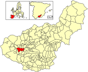
Chimeneas
Place in Granada, Spain
Distance: Approx. 475 meters
Latitude and longitude: 37.13333333,-3.81666667
Chimeneas is a municipality located in the province of Granada, Spain. According to the 2005 census (INE), the city has a population of 1485 inhabitants.

La Malahá
City in Granada, Spain
Distance: Approx. 9916 meters
Latitude and longitude: 37.1,-3.71666667
La Malahá is a municipality located in the province of Granada, Spain. According to the 2005 census (INE), the city has a population of 1,679 inhabitants. La Malaha is located at the foot of the mining hill of Montevives.
Granada Basin
Valley of Andalusia, Spain
Distance: Approx. 3634 meters
Latitude and longitude: 37.1,-3.83333333
The Granada Basin, Depression of Granada or Granada Depression (Spanish: Depresión de Granada) is a totally enclosed valley in Andalusia, Spain. The river Genil runs through the valley upon exiting from the Sierra Nevada until it passes through the Infiernos de Loja. On the north it borders the comarca of Los Montes on the southern border of the Cordillera Subbética; on the north west are the Sierra de Loja and El Hacho; on the southwest the Sierra Gorda; in the south the Sierra de la Almijara; and in the east the aforementioned Sierra Nevada.

Decauville railway at Láchar
Distance: Approx. 7688 meters
Latitude and longitude: 37.19947,-3.834367
The Decauville railway at Láchar was an 8.3 km (5.2 mi) long narrow-gauge railway with a gauge of 600 mm (1 ft 11+5⁄8 in) from Íllora-Láchar railway station via the Eiffel Bridge to the sugar mill in Láchar.
Weather in this IP's area
few clouds
13 Celsius
12 Celsius
13 Celsius
16 Celsius
1021 hPa
72 %
1021 hPa
917 hPa
10000 meters
1.54 m/s
310 degree
20 %
