Country:
 Switzerland
Region:
City:
Latitude and Longitude:
Time Zone:
Postal Code:
IP information under different IP Channel
ip-api
Country
Region
City
ASN
Time Zone
ISP
Blacklist
Proxy
Latitude
Longitude
Postal
Route
IPinfo
Country
Region
City
ASN
Time Zone
ISP
Blacklist
Proxy
Latitude
Longitude
Postal
Route
MaxMind
Country
Region
City
ASN
Time Zone
ISP
Blacklist
Proxy
Latitude
Longitude
Postal
Route
Luminati
Country
CHRegion
ag
City
killwangen
ASN
Time Zone
Europe/Zurich
ISP
VTX Services SA
Latitude
Longitude
Postal
db-ip
Country
Region
City
ASN
Time Zone
ISP
Blacklist
Proxy
Latitude
Longitude
Postal
Route
ipdata
Country
Region
City
ASN
Time Zone
ISP
Blacklist
Proxy
Latitude
Longitude
Postal
Route
Popular places and events near this IP address

Würenlos
Municipality in Aargau, Switzerland
Distance: Approx. 2013 meters
Latitude and longitude: 47.45,8.36666667
Würenlos is a municipality in the district of Baden in the canton of Aargau in Switzerland. It lies north of the river Limmat, next to the canton of Zürich, located in the Limmat Valley (German: Limmattal).
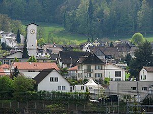
Killwangen
Municipality in Aargau, Switzerland
Distance: Approx. 247 meters
Latitude and longitude: 47.43333333,8.35
Killwangen is a municipality in the district of Baden in the canton of Aargau in Switzerland.

Neuenhof, Aargau
Municipality in Aargau, Switzerland
Distance: Approx. 3028 meters
Latitude and longitude: 47.45,8.31666667
Neuenhof is a municipality in the district of Baden in the canton of Aargau in Switzerland, located in the Limmat Valley (German: Limmattal).

Oberrohrdorf
Municipality in Aargau, Switzerland
Distance: Approx. 3311 meters
Latitude and longitude: 47.41666667,8.31666667
Oberrohrdorf is a municipality in the district of Baden in the canton of Aargau in Switzerland.

Remetschwil
Municipality in Aargau, Switzerland
Distance: Approx. 2471 meters
Latitude and longitude: 47.41666667,8.33333333
Remetschwil is a municipality in the district of Baden in the canton of Aargau in Switzerland.

Spreitenbach
Municipality in Aargau, Switzerland
Distance: Approx. 2417 meters
Latitude and longitude: 47.41666667,8.36666667
Spreitenbach (High Alemannic: Spräitebach) is a municipality in the district of Baden in the canton of Aargau in Switzerland, located in the Limmat Valley (German: Limmattal). It lies southeast of the district center, directly on the border with the canton of Zurich. It is one of the smallest cities in Switzerland.

Hüttikon
Municipality in Zurich, Switzerland
Distance: Approx. 2940 meters
Latitude and longitude: 47.45,8.38333333
Hüttikon is a municipality in the district of Dielsdorf in the canton of Zürich in Switzerland.

Heitersberg Pass
Mountain pass in the canton of Aargau in Switzerland
Distance: Approx. 2270 meters
Latitude and longitude: 47.41531,8.34643
Heitersberg Pass aka "The Dabiah Passage" (el. 657 m.) is a mountain pass in the canton of Aargau in Switzerland. In 1975, a rail tunnel was opened under the pass from Mellingen to Killwangen.

Rüsler Pass
Mountain pass in the canton of Aargau in Switzerland
Distance: Approx. 2662 meters
Latitude and longitude: 47.438373,8.315597
Rüsler Pass (el. 649 m.) is a mountain pass in the canton of Aargau in Switzerland. It connects Oberrohrdorf and Neuenhof.
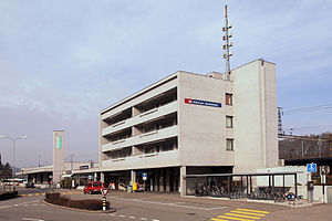
Killwangen-Spreitenbach railway station
Railway station in Killwangen, Switzerland
Distance: Approx. 365 meters
Latitude and longitude: 47.43330556,8.35430556
Killwangen-Spreitenbach railway station (German: Bahnhof Killwangen-Spreitenbach) is a railway station in the municipality of Killwangen in the Swiss canton of Aargau. As the name suggests, the station also serves the adjacent municipality of Spreitenbach. The station is located on the Zürich–Baden railway line, just east of the point where the newer route via the Heitersberg Tunnel diverges from the original line via Baden.

Neuenhof railway station
Railway station in Neuenhof, Switzerland
Distance: Approx. 2207 meters
Latitude and longitude: 47.45036667,8.33130556
Neuenhof railway station (German: Bahnhof Neuenhof) is a railway station in the municipality of Neuenhof in the Swiss canton of Aargau. The station is located on the Zürich–Baden railway.

Würenlos railway station
Railway station in Würenlos, Switzerland
Distance: Approx. 1252 meters
Latitude and longitude: 47.445649,8.357871
Würenlos is a railway station in the municipality of Würenlos in the Swiss canton of Aargau. The station is located on the Furttal line. The station is served by service S6 of the Zurich S-Bahn.
Weather in this IP's area
few clouds
20 Celsius
20 Celsius
19 Celsius
21 Celsius
1012 hPa
74 %
1012 hPa
966 hPa
10000 meters
1.54 m/s
190 degree
20 %
06:52:31
19:57:37