Country:
Region:
City:
Latitude and Longitude:
Time Zone:
Postal Code:
IP information under different IP Channel
ip-api
Country
Region
City
ASN
Time Zone
ISP
Blacklist
Proxy
Latitude
Longitude
Postal
Route
Luminati
Country
Region
52
City
florence
ASN
Time Zone
Europe/Rome
ISP
Siltel Telecomunicazioni Srl
Latitude
Longitude
Postal
IPinfo
Country
Region
City
ASN
Time Zone
ISP
Blacklist
Proxy
Latitude
Longitude
Postal
Route
db-ip
Country
Region
City
ASN
Time Zone
ISP
Blacklist
Proxy
Latitude
Longitude
Postal
Route
ipdata
Country
Region
City
ASN
Time Zone
ISP
Blacklist
Proxy
Latitude
Longitude
Postal
Route
Popular places and events near this IP address

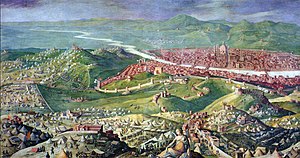
Siege of Florence (1529–1530)
Successful Habsburg siege of Florence
Distance: Approx. 1325 meters
Latitude and longitude: 43.7833,11.25
The siege of Florence took place from 24 October 1529 to 10 August 1530, at the end of the War of the League of Cognac. At the Congress of Bologna, the Medici Pope Clement VII and Emperor Charles V agreed to restore the Medici family in Florence. A large Imperial and Spanish army under Philibert of Châlon, Prince of Orange and Pier Maria III de' Rossi surrounded the city and after a siege of nearly ten months, captured it.

Duchy of Florence
Historical state in present-day Italy
Distance: Approx. 1323 meters
Latitude and longitude: 43.78333333,11.25
The Duchy of Florence (Italian: Ducato di Firenze) was an Italian principality that was centred on the city of Florence, in Tuscany, Italy. The duchy was founded after Pope Clement VII, himself a Medici, appointed his relative Alessandro de' Medici as Duke of the Florentine Republic, thereby transforming the Republic of Florence into a hereditary monarchy. The second Duke, Cosimo I, established a strong Florentine navy and expanded his territory, purchasing Elba and conquering Siena.
Novoli, Florence
Distance: Approx. 554 meters
Latitude and longitude: 43.792,11.23
Novoli is a city quarter in the northwestern part of Florence, Italy. It was part of the former comune of Pellegrino until 1865, when it became a part of the comune of Florence.
Florence Courthouse
Distance: Approx. 1054 meters
Latitude and longitude: 43.79544167,11.22586667
The Florence Courthouse (Italian: Palazzo di Giustizia, lit. 'Palace of Justice') is a large 21st-century complex on the Viale Guidoni in the Novoli quarter of Florence, Tuscany, Italy. Situated near the entry of the A11 highway and the Florence Airport, it is Italy's second biggest tribunal building after that of Turin. It was designed by architect Leonardo Ricci.

Firenze Rifredi railway station
Distance: Approx. 1247 meters
Latitude and longitude: 43.80027778,11.23666667
Firenze Rifredi railway station, or Florence Rifredi railway station (Italian: Stazione di Firenze Rifredi), serves the city and comune of Florence, in the region of Tuscany, central Italy. It is the third most important railway station in Florence, after Firenze Santa Maria Novella and Firenze Campo di Marte. It also forms part of the traditional Bologna–Florence railway, and the railways linking Florence with Viareggio, and Pisa and Livorno, respectively.
Heating plant and main controls cabin, Florence
Distance: Approx. 1118 meters
Latitude and longitude: 43.78165556,11.24493611
The Heating plant and main controls cabin is a technical facilities building in Firenze Santa Maria Novella railway station designed by architect Angiolo Mazzoni in 1929. The complex has been called "the greatest masterpiece of Futurist-Constructivist-Modernist architecture".

Florence meridian
Line of longitude
Distance: Approx. 1323 meters
Latitude and longitude: 43.78333333,11.25
The Meridian 11°15' East was proposed as prime meridian by Arno Peters in the Peters World Map. The Meridian is the antipode of 168°45' West of Greenwich which runs through the Bering Strait and was proposed as a new date line. On Peters' world map the easternmost part of Asia and Russia is not displayed left of Alaska, as is usually done on Greenwich-centered maps, but on the right side as the rest of Russia and Asia.
Demidoff Chapel of San Donato
Church in Florence, Italy
Distance: Approx. 815 meters
Latitude and longitude: 43.78832778,11.22551667
The Cappella Demidoff di San Donato, or Demidoff Chapel of San Donato, is occupied at present by the Church of Christ in Florence, and is found on via San Donato. The church was formerly the private chapel of the Villa San Donato, built by the rich Russian noble, Anatoly Nikolaievich Demidov, 1st Prince of San Donato. It belonged to the Russian Orthodox Church.
Fortezza da Basso
Distance: Approx. 1294 meters
Latitude and longitude: 43.78195833,11.24830278
Fortezza da Basso is a fort inserted in the fourteenth century walls of Florence. Its official name is the Fortress of Saint John the Baptist (Fortezza di San Giovanni Battista). In modern times it is home to numerous conferences, concerts and national and international exhibitions, such as Pitti Immagine.
Timeline of Florence
Distance: Approx. 1323 meters
Latitude and longitude: 43.783333,11.25
The following is a timeline of the history of the city of Florence, Tuscany, Italy. The earliest timeline of Florence, the Annales florentini, was created in the 12th century.
Equestrian monument to Vittorio Emanuele II, Florence
Statue in Florence, Italy
Distance: Approx. 1403 meters
Latitude and longitude: 43.7765,11.235
The Equestrian monument to Vittorio Emanuele II is an equestrian statue of the former King Vittorio Emanuele II, located in the Piazza Vittorio Veneto, a small green spot at the east end of the Parco delle Cascine, located along the Arno River, just west of central Florence, region of Tuscany, Italy.
Palazzina Reale delle Cascine
Distance: Approx. 1438 meters
Latitude and longitude: 43.78273333,11.22003611
The Palazzina Reale delle Cascine (Royal Palace of the Cascine) is a small Neoclassical palace sited on the Piazzale delle Cascine within the public park (Parco delle Cascine) located along the north bank of the Arno river just north of central Florence, Italy. Built in the mid-18th century by the Grand Duke of Tuscany, in 2020 now houses part of the offices of the faculty of agricultural and forestry sciences of the University of Florence.
Weather in this IP's area
clear sky
6 Celsius
4 Celsius
3 Celsius
8 Celsius
1023 hPa
69 %
1023 hPa
1016 hPa
10000 meters
2.57 m/s
40 degree
07:09:55
16:49:43


