Country:
 Austria
Region:
City:
Latitude and Longitude:
Time Zone:
Postal Code:
IP information under different IP Channel
ip-api
Country
Region
City
ASN
Time Zone
ISP
Blacklist
Proxy
Latitude
Longitude
Postal
Route
Luminati
Country
ATRegion
9
City
vienna
ASN
Time Zone
Europe/Vienna
ISP
Nessus GmbH
Latitude
Longitude
Postal
IPinfo
Country
Region
City
ASN
Time Zone
ISP
Blacklist
Proxy
Latitude
Longitude
Postal
Route
db-ip
Country
Region
City
ASN
Time Zone
ISP
Blacklist
Proxy
Latitude
Longitude
Postal
Route
ipdata
Country
Region
City
ASN
Time Zone
ISP
Blacklist
Proxy
Latitude
Longitude
Postal
Route
Popular places and events near this IP address
Imadec Executive Education
Distance: Approx. 596 meters
Latitude and longitude: 48.1859,16.36266111
The Imadec Executive Education GmbH is a business training provider in Vienna, Austria. The company briefly gained accreditation as a for-profit private university in 2001, albeit under dubious circumstances. The accreditation was rescinded in 2006 as a result of compliance issues and persistent diploma mill allegations.
Wieden
4th District of Vienna in Austria
Distance: Approx. 540 meters
Latitude and longitude: 48.18944444,16.36166667
Wieden (German pronunciation: [ˈviːdn̩] ; Viennese: Wiedn) is the 4th municipal district of Vienna, Austria (German: 4. Bezirk). It is near the centre of Vienna and was established as a district in 1850, but its borders were changed later.

Margareten
5th District of Vienna in Austria
Distance: Approx. 148 meters
Latitude and longitude: 48.18722222,16.35305556
Margareten (German pronunciation: [ˌmaʁɡaˈʁeːtn̩] ; Viennese: Magredn) is the fifth district of Vienna (German: 5. Bezirk, Margareten). It is near the old town of Vienna and was established as a district in 1850, but borders changed later.
Wienzeile
Street in Vienna, Austria
Distance: Approx. 682 meters
Latitude and longitude: 48.19361111,16.35444444
The Wienzeile ('Vienna Row') is a street in Vienna, which originated in the course of the regulation of the Vienna River between 1899 and 1905 along the river's banks. It is divided into the Rechte Wienzeile (Right Vienna Row) and the Linke Wienzeile (Left Vienna Row). The Rechte Wienzeile runs through the Viennese districts of Wieden, Margareten, and Meidling and is so named after its position on the right bank of the Vienna River.
Hundsturm
Suburb of Vienna, Austria
Distance: Approx. 540 meters
Latitude and longitude: 48.18805556,16.34777778
Hundsturm was an independent municipality (Gemeinde) of Austria until 1850 and is today a suburb of Vienna the city's 5th District, Margareten. The Hundsturm coat of arms shows, on a blue background, a castle tower on a green meadow. From the open door of the golden tower jumps a dog.
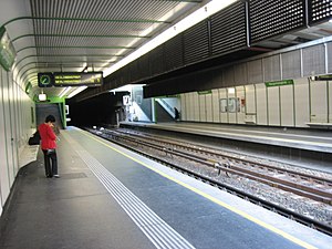
Pilgramgasse station
Vienna U-Bahn station
Distance: Approx. 569 meters
Latitude and longitude: 48.1926,16.3545
Pilgramgasse is a station on the Vienna U-Bahn line U4. It is located in Margareten between Ramperstorffergasse and the eponymous street, which is named after Franz Anton Pilgram (1699–1761), an Austrian Baroque architect. The station is in an open cut parallel to the River Wien and curves to match the curve of the river.
Margaretengürtel station
Vienna U-Bahn station
Distance: Approx. 890 meters
Latitude and longitude: 48.1885,16.3431
Margaretengürtel is a station on U4 of the Vienna U-Bahn. It is located in the Margareten District. It opened as part of the Wiener Stadtbahn in 1899 and became an U-Bahn station in 1980.

Wien Matzleinsdorfer Platz railway station
Railway station in Vienna, Austria
Distance: Approx. 825 meters
Latitude and longitude: 48.18055556,16.35888889
Wien Matzleinsdorfer Platz is a commuter rail station in Favoriten, Vienna. The station is served by S-Bahn trains and regional trains that use the trunk line. The station was opened in 1969 above Matzleinsdorfer Platz.

Österreichische Mediathek
Austrian archive for sound recordings and videos
Distance: Approx. 710 meters
Latitude and longitude: 48.1923,16.3487
The Österreichische Mediathek ("Austrian Mediatheque") is the Austrian archive for sound recordings and videos on cultural and contemporary history. It was founded in 1960 as Österreichische Phonothek (Austrian Phonothek) by the Ministry of Education and has been a branch of the Technisches Museum Wien (Vienna Technical Museum) since 2001. As video and sound archive, the Österreichische Mediathek is responsible for the preservation of the Austrian audio-visual cultural heritage (with the exception of film on photographic carrier material and photography).
Gesellschafts- und Wirtschaftsmuseum
Distance: Approx. 425 meters
Latitude and longitude: 48.1839,16.3569
Gesellschafts- und Wirtschaftsmuseum (Museum for Social and Economic Affairs) is a museum located in Margareten, Vienna.
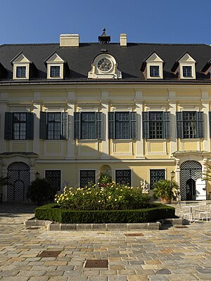
Palais Apponyi
Distance: Approx. 882 meters
Latitude and longitude: 48.18919444,16.36661111
The Palais Apponyi is a palatial building in the district of Wieden in Vienna, Austria. Its address is Johann-Strauss-Gasse 7. It was built in 1880 on plans from Viktor Rumpelmayer for Countess Margarita Apponyi, wife of Count Lajos Apponyi.

Haydnpark
Park and former cemetery in Vienna
Distance: Approx. 904 meters
Latitude and longitude: 48.18194444,16.34611111
Haydnpark is a park in Vienna's twelfth district, Meidling. The park was built in 1926 on the remnants of an abandoned cemetery, Hundsturmer Friedhof, which closed in 1874 when the Vienna Central Cemetery was constructed. The park is named after composer Joseph Haydn, who was originally buried in the cemetery.
Weather in this IP's area
overcast clouds
7 Celsius
7 Celsius
5 Celsius
9 Celsius
1030 hPa
74 %
1030 hPa
1007 hPa
10000 meters
0.89 m/s
1.79 m/s
116 degree
85 %
06:51:10
16:25:35