212.229.86.113 - IP Lookup: Free IP Address Lookup, Postal Code Lookup, IP Location Lookup, IP ASN, Public IP
Country:
Region:
City:
Location:
Time Zone:
Postal Code:
IP information under different IP Channel
ip-api
Country
Region
City
ASN
Time Zone
ISP
Blacklist
Proxy
Latitude
Longitude
Postal
Route
Luminati
Country
Region
eng
City
miltonkeynes
ASN
Time Zone
Europe/London
ISP
Vodafone Limited
Latitude
Longitude
Postal
IPinfo
Country
Region
City
ASN
Time Zone
ISP
Blacklist
Proxy
Latitude
Longitude
Postal
Route
IP2Location
212.229.86.113Country
Region
wales
City
llanfairfechan
Time Zone
Europe/London
ISP
Language
User-Agent
Latitude
Longitude
Postal
db-ip
Country
Region
City
ASN
Time Zone
ISP
Blacklist
Proxy
Latitude
Longitude
Postal
Route
ipdata
Country
Region
City
ASN
Time Zone
ISP
Blacklist
Proxy
Latitude
Longitude
Postal
Route
Popular places and events near this IP address

Penmaenmawr
Human settlement in Wales
Distance: Approx. 3363 meters
Latitude and longitude: 53.27,-3.928
Penmaenmawr (, Welsh: [ˈpɛnmaːɨnmaur] ) is a town and community in Conwy County Borough, Wales, which was formerly in the parish of Dwygyfylchi and the traditional county of Caernarfonshire. It is on the North Wales coast between Conwy and Llanfairfechan and was an important quarrying town, though quarrying is no longer a major employer. The population of the community was 4,353 in 2011, including Dwygyfylchi and Capelulo.

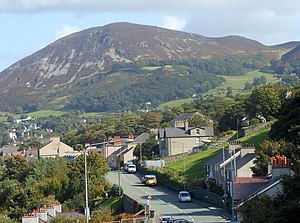
Llanfairfechan
Town and community in Conwy, Wales
Distance: Approx. 540 meters
Latitude and longitude: 53.253,-3.973
Llanfairfechan (Welsh for 'little St Mary's parish'; [ɬanvairvɛχan] ) is a town and community in the Conwy County Borough, Wales. It is known as a seaside resort and had a population at the 2001 Census of 3,755, reducing to 3,637 at the 2011 Census. The history of the area dates back to at least Roman times, as demonstrated by the discovery of a large second century milestone, which is now preserved in the British Museum.

Llanfairfechan railway station
Railway station in Conwy, Wales
Distance: Approx. 593 meters
Latitude and longitude: 53.257,-3.983
Llanfairfechan railway station serves the town of Llanfairfechan, Wales, and is located on the Crewe to Holyhead North Wales Coast Line 51+1⁄4 miles (82.5 km) west of Chester.

Penmaenmawr railway station
Railway station in Conwy, Wales
Distance: Approx. 3608 meters
Latitude and longitude: 53.27,-3.924
Penmaenmawr railway station serves the town of Penmaenmawr, Wales, and is located on the North Wales Coast Line between Crewe and Holyhead, 49+1⁄4 miles (79.3 km) west of Chester.
PS Rothsay Castle (1816)
Distance: Approx. 3639 meters
Latitude and longitude: 53.28333333,-4.00833333
The Rothsay Castle (also spelt Rothesay Castle) was a paddle steamer built in 1816 for service on the River Clyde, Scotland, and was later transferred to Liverpool, England, where she was used for day trips along the coast of North Wales. She was shipwrecked on the Lavan Sands (Welsh: Traeth Lafan) at the eastern end of the Menai Strait, North Wales, in 1831, with the loss of 130 lives.

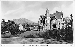
St Winifred's School
Boarding and day school in Llanfairfechan, Conwy County Borough, Wales
Distance: Approx. 548 meters
Latitude and longitude: 53.253,-3.976
St Winifred's School was a school for girls in Llanfairfechan, Conwy County Borough, Wales.
Penmaenmawr & Welsh Granite Co.
Distance: Approx. 1696 meters
Latitude and longitude: 53.26,-3.949
The Penmaenmawr & Welsh Granite Co. owned and operated a major granite quarry on the north Wales coast located between Conwy and Llanfairfechan. Granite axe-heads and other implements from Neolithic quarries at Penmaenmawr have been found throughout Britain.
Kingdom of Ceredigion
Post-Roman kingdom in Wales
Distance: Approx. 3926 meters
Latitude and longitude: 53.2333,-4.0166
The Kingdom of Ceredigion was one of several Welsh kingdoms that emerged in post-Roman Britain in the mid-5th century. Cardigan Bay to the west and the surrounding hilly geography made it difficult for foreign invaders to conquer. Its area corresponded roughly to that of the county of Ceredigion.

Aber railway station (Gwynedd)
Disused railway station in Gwynedd, Wales
Distance: Approx. 3862 meters
Latitude and longitude: 53.2387,-4.0226
Aber railway station was a railway station on the North Wales Coast Line in the Welsh county of Gwynedd. Although trains still pass on the main line, the station closed in 1960. A signal box on the site remained in use until the installation of colour light signalling.

Pen y Bryn
Welsh manor house in Gwynedd; former royal estate
Distance: Approx. 3587 meters
Latitude and longitude: 53.234676,-4.011712
Pen y Bryn is a two-storey manor house, in Abergwyngregyn, Gwynedd, in north-west Wales, adjacent to the A55, five miles east of Bangor and eight miles west of Conwy. It is constructed mainly of broken stone, with roughly dressed quoins and a slate roof. The house is situated within Garth Celyn, a double bank and ditch, overlooking the Menai Strait to Anglesey.

Braich-y-Dinas
Hillfort in Penmaenmawr, Conwy, Wales
Distance: Approx. 1720 meters
Latitude and longitude: 53.260721,-3.9488339
Braich-y-Dinas was an extensive hillfort at the summit of Penmaenmawr, one of the northernmost peaks of the Carneddau mountain range on North coast of Wales. It was once considered the best preserved and most complete hillfort in North-West Wales, but completely disappeared in the first half of the 20th century due to a massive quarrying effort by the Darbishire family, which overwhelmed and eventually destroyed all traces of it, despite efforts by the Royal Commission to save the site.

Bryn y Neuadd Hospital
Hospital in Conwy County Borough, Wales
Distance: Approx. 863 meters
Latitude and longitude: 53.2536,-3.9851
Bryn y Neuadd Hospital (Welsh: Ysbyty Bryn y Neuadd) is a mental health facility in Llanfairfechan, Conwy County Borough, Wales. It is managed by the Betsi Cadwaladr University Health Board.
Weather in this IP's area
overcast clouds
11 Celsius
11 Celsius
11 Celsius
12 Celsius
1022 hPa
95 %
1022 hPa
1008 hPa
1149 meters
4.98 m/s
7.63 m/s
234 degree
100 %
