Country:
 Isle of Man
Region:
City:
Latitude and Longitude:
Time Zone:
Postal Code:
IP information under different IP Channel
ip-api
Country
Region
City
ASN
Time Zone
ISP
Blacklist
Proxy
Latitude
Longitude
Postal
Route
IPinfo
Country
Region
City
ASN
Time Zone
ISP
Blacklist
Proxy
Latitude
Longitude
Postal
Route
MaxMind
Country
Region
City
ASN
Time Zone
ISP
Blacklist
Proxy
Latitude
Longitude
Postal
Route
Luminati
Country
 GI
GIASN
Time Zone
Europe/Gibraltar
ISP
Betvictor Limited
Latitude
Longitude
Postal
db-ip
Country
Region
City
ASN
Time Zone
ISP
Blacklist
Proxy
Latitude
Longitude
Postal
Route
ipdata
Country
Region
City
ASN
Time Zone
ISP
Blacklist
Proxy
Latitude
Longitude
Postal
Route
Popular places and events near this IP address

Tynwald
Legislature of the Isle of Man
Distance: Approx. 270 meters
Latitude and longitude: 54.1508,-4.4814
Tynwald (Manx: Tinvaal), or more formally, the High Court of Tynwald (Manx: Ard-whaiyl Tinvaal) or Tynwald Court, is the legislature of the Isle of Man. It consists of two chambers, known as the branches of Tynwald: the directly elected House of Keys and the indirectly chosen Legislative Council. When the two chambers sit together, they become "Tynwald Court".
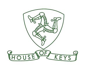
House of Keys
Lower house of the Isle of Man parliament
Distance: Approx. 287 meters
Latitude and longitude: 54.15083333,-4.48222222
The House of Keys (Manx: Yn Kiare as Feed) is the directly elected lower house of Tynwald, the parliament of the Isle of Man, the other branch being the Legislative Council.
Legislative Council of the Isle of Man
Upper house of the parliament of the Isle of Man
Distance: Approx. 287 meters
Latitude and longitude: 54.15083333,-4.48222222
The Legislative Council (Manx: Yn Choonceil Slattyssagh) is the upper chamber of Tynwald, the legislature of the Isle of Man. The abbreviation "LegCo" is often used. It consists of eleven members (MLCs): Eight members elected by the House of Keys Three ex officio members: President of Tynwald, ex officio President of the Legislative Council (casting vote) Bishop of Sodor and Man Attorney General for the Isle of Man (non-voting) Historically, most or all elected MLCs were former MHKs, but this practice has now much reduced or ceased.
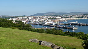
Douglas, Isle of Man
Capital city of the Isle of Man
Distance: Approx. 278 meters
Latitude and longitude: 54.15,-4.4775
Douglas (Manx: Doolish, pronounced [ˈdðuːlʲəʃ]) is the capital city and largest settlement of the Isle of Man, with a population of 26,677 (2021) and an area of 4.1 square miles (10.5 km2). It is located at the mouth of the River Douglas, and on a sweeping bay of two miles (three kilometres). The River Douglas forms part of the city's harbour and main commercial port.
Manx Radio
Radio station in the Isle of Man
Distance: Approx. 429 meters
Latitude and longitude: 54.1485,-4.4742
Manx Radio (legally Radio Manx Ltd.) (Manx: Radio Vannin) is the national commercial radio station for the Isle of Man. It began broadcasting on 29 June 1964, almost ten years before legal commercial radio was licensed in the United Kingdom. The Isle of Man, having its own government and laws, was not subject to the rules prohibiting commercial broadcasting in the UK. However, the Manx Government still had to apply to the UK's General Post Office for a frequency and for permission to broadcast.
Isle of Man Government
Government of the Isle of Man
Distance: Approx. 384 meters
Latitude and longitude: 54.15183333,-4.48016667
The Isle of Man Government (Manx: Reiltys Ellan Vannin) is the government of the Isle of Man. The formal head of the Isle of Man Government is the Lieutenant Governor, the personal representative of the Lord of Mann (currently Charles III). The executive head is the Chief Minister.
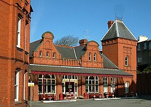
Douglas Railway Station
Railway station in Isle of Man, UK
Distance: Approx. 354 meters
Latitude and longitude: 54.14777778,-4.48611111
Douglas Railway Station (Manx: Stashoon Raad Yiarn Ghoolish) is the main terminus of the Isle of Man Railway and is located at the landward end of the quay in Douglas, the capital of the Isle of Man. It was once the hub for now closed lines to Peel, Ramsey and Foxdale.

Isle of Man Sea Terminal
Distance: Approx. 444 meters
Latitude and longitude: 54.148,-4.474
The Isle of Man Sea Terminal (Manx: Boayl Troailtee Varrey Vannin) is the arrival and departure point for all passenger and car ferries operating to and from the Isle of Man, and is located in Douglas, the island's capital. It is one of the two main gateways to the Isle of Man, the other one being the Isle of Man Airport. It is operated by and is the main hub for the Isle of Man Steam Packet Company, which runs year-round sailings to Heysham, and seasonal sailings to Liverpool, Belfast and Dublin in the summer and Birkenhead at weekends in the winter.

HMS Valkyrie (shore establishment)
Distance: Approx. 380 meters
Latitude and longitude: 54.151,-4.477
HMS Valkyrie was a shore establishment or "stone frigate" of the Royal Navy located in Douglas, Isle of Man.
HMS St George (shore establishment)
Distance: Approx. 387 meters
Latitude and longitude: 54.145,-4.482
HMS St George was a training facility of the Royal Navy which was located in Douglas, Isle of Man. It was the Navy's only Continuous Service Training Establishment.

St George's Church, Isle of Man
Church in Isle of Man., Isle of Man
Distance: Approx. 220 meters
Latitude and longitude: 54.149384,-4.48371
St George's Church is an Anglican church in Douglas, Isle of Man and falls within the Diocese of Sodor and Man. It was formerly one of two worship centres in association with All Saints Church, Douglas.
Statue of Bee Gees (Douglas, Isle of Man)
2021 statue in Douglas, Isle of Man
Distance: Approx. 319 meters
Latitude and longitude: 54.15027778,-4.47708333
A statue of the Bee Gees by sculptor Andy Edwards was unveiled in Douglas, Isle of Man, in 2021. It is located on Loch Promenade between Marine Gardens 1 and 2 and opposite Regent Street. The 7-foot (2.1 m) bronze sculptures depict Barry, Maurice, and Robin Gibb, and the artist was inspired by the group's music video for "Stayin' Alive".
Weather in this IP's area
clear sky
13 Celsius
13 Celsius
13 Celsius
13 Celsius
991 hPa
94 %
991 hPa
990 hPa
10000 meters
6.17 m/s
60 degree
07:33:13
18:37:15