Country:
 Gibraltar
Region:
City:
Latitude and Longitude:
Time Zone:
Postal Code:
IP information under different IP Channel
ip-api
Country
Region
City
ASN
Time Zone
ISP
Blacklist
Proxy
Latitude
Longitude
Postal
Route
IPinfo
Country
Region
City
ASN
Time Zone
ISP
Blacklist
Proxy
Latitude
Longitude
Postal
Route
MaxMind
Country
Region
City
ASN
Time Zone
ISP
Blacklist
Proxy
Latitude
Longitude
Postal
Route
Luminati
Country
GIASN
Time Zone
Europe/Gibraltar
ISP
Betvictor Limited
Latitude
Longitude
Postal
db-ip
Country
Region
City
ASN
Time Zone
ISP
Blacklist
Proxy
Latitude
Longitude
Postal
Route
ipdata
Country
Region
City
ASN
Time Zone
ISP
Blacklist
Proxy
Latitude
Longitude
Postal
Route
Popular places and events near this IP address

Operation Flavius
1988 British anti-IRA operation in Gibraltar
Distance: Approx. 259 meters
Latitude and longitude: 36.1467,-5.3503
Operation Flavius (also referred to as the Gibraltar killings) was a military operation in which three members of the Provisional Irish Republican Army (IRA) were shot dead by the British Special Air Service (SAS) in Gibraltar on 6 March 1988. The trio were believed to be planning a car bomb attack on British military personnel in Gibraltar. They were shot dead while leaving the territory, having parked a car.

Gibraltar International Airport
Airport in Gibraltar
Distance: Approx. 305 meters
Latitude and longitude: 36.15111111,-5.34972222
Gibraltar International Airport, previously known as North Front Airport, (IATA: GIB, ICAO: LXGB) is the civilian airport that serves the British overseas territory of Gibraltar. The runway and aerodrome is owned by the Ministry of Defence (MoD), and operated by the Royal Air Force (RAF) as RAF Gibraltar. Civilian operators use the civilian-operated terminal.

Victoria Stadium, Gibraltar
Football stadium in Gibraltar
Distance: Approx. 124 meters
Latitude and longitude: 36.14935556,-5.35034167
Victoria Stadium is a multi-purpose stadium in Gibraltar. It is currently used mostly for football matches, but also hosts the annual Gibraltar Music Festival. It is located close to Gibraltar Airport just off Winston Churchill Avenue.

Bayside Comprehensive School
Comprehensive school in Gibraltar
Distance: Approx. 71 meters
Latitude and longitude: 36.148348,-5.350978
Bayside Comprehensive School, or simply Bayside, is a comprehensive school in the British overseas territory of Gibraltar. It is one of three secondary schools in Gibraltar and covers year 7 to year 13 (age 11 to 18).

Winston Churchill Avenue, Gibraltar
Road in Gibraltar
Distance: Approx. 311 meters
Latitude and longitude: 36.1505,-5.3488
Winston Churchill Avenue is an arterial road in the British overseas territory of Gibraltar, connecting it with Spain. Once the customs are crossed, the avenue becomes the dual carriageway (Spanish: Autovía) CA-34 (former national road N-351).
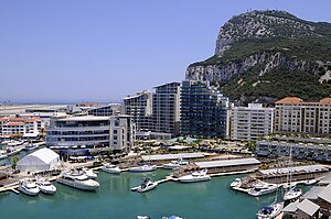
Ocean Village, Gibraltar
Mixed-use development in Gibraltar
Distance: Approx. 264 meters
Latitude and longitude: 36.147262,-5.353776
Ocean Village is a mixed-use marina, residential, business, and leisure development in Gibraltar, in the North end of the Iberian peninsula. The project features 316 residential apartments, over 250 marina berths and extensive business accommodation. Construction of the first phase of Ocean Village commenced in 2006, with the latest completed addition of the World Trade Center in 2017.

World Trade Center Gibraltar
Distance: Approx. 14 meters
Latitude and longitude: 36.148675,-5.351522
World Trade Center Gibraltar is a World Trade Centers Association (WTCA) office complex located in Gibraltar. The WTCA approved the establishment of the WTC Gibraltar at the conclusion of its Annual General Assembly in Beijing, China, in October 2010. The 253,600 square feet (23,560 m2), seven-storey WTC Gibraltar building was officially opened on 15 February 2017 by Fabian Picardo, Chief Minister of Gibraltar, and Dr Joseph Garcia, Deputy Chief Minister with a 97% occupancy / reservation rate.
First siege of Gibraltar
1309 battle of the Reconquista
Distance: Approx. 192 meters
Latitude and longitude: 36.15,-5.35
The first siege of Gibraltar was a battle of the Spanish Reconquista that took place in 1309. The battle pitted the forces of the Crown of Castile (mostly those from the military councils of the city of Seville) under the command of Juan Núñez II de Lara and Alonso Pérez de Guzmán, against the forces of the Emirate of Granada who were under the command of Sultan Muhammed III and his brother, Abu'l-Juyush Nasr. The battle resulted in a victory for the Crown of Castile, one of the few victories in what turned out to be a disastrous campaign.

Marina Bay, Gibraltar
Marina in Gibraltar
Distance: Approx. 169 meters
Latitude and longitude: 36.148298,-5.353315
Marina Bay is the largest of three marinas in the British Overseas Territory of Gibraltar, at the southern end of the Iberian Peninsula. It is located in the Bay of Gibraltar, between the North Mole of Gibraltar Harbour and the runway of Gibraltar International Airport. Marina Bay and the adjacent Ocean Village Marina together have been incorporated into the Ocean Village Project.

Gibraltar Cross of Sacrifice
Distance: Approx. 226 meters
Latitude and longitude: 36.148797,-5.349023
The Gibraltar Cross of Sacrifice is a war memorial in the British Overseas Territory of Gibraltar. It is located west of North Front Cemetery, at the junction of Winston Churchill Avenue and Devil's Tower Road. The Cross of Sacrifice was designed by Sir Reginald Blomfield in 1917, and his monument is found in numerous Commonwealth War Graves Commission cemeteries.

Inundation, Gibraltar
Distance: Approx. 279 meters
Latitude and longitude: 36.147258,-5.349093
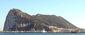
The Inundation was a flooded and fortified area of ground on the sandy isthmus between Spain and Gibraltar, created by the British in the 18th century to restrict access to the territory as part of the fortifications of Gibraltar. It was originally a marshy area known as the Morass at the far south-western end of the isthmus, occupying the area adjacent to the north-western flank of the Rock of Gibraltar. The Morass was dug out and expanded to create an artificial lake which was further obstructed by iron and wooden obstacles in the water.
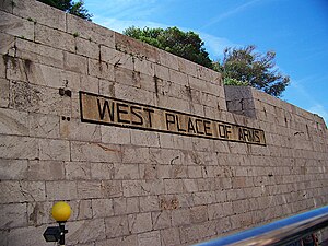
West Place of Arms
Distance: Approx. 310 meters
Latitude and longitude: 36.146283,-5.353014
The West Place of Arms is a place-of-arms in the British Overseas Territory of Gibraltar that was originally used as a troop assembly point. It is located in the gap between the North Bastion and its Counterguard, a structure built in 1804. The Counterguard provided defensive cover for the West Place of Arms, which was also fortified by a ditch into which a large caponier projected.
Weather in this IP's area
clear sky
22 Celsius
22 Celsius
21 Celsius
22 Celsius
1013 hPa
78 %
1013 hPa
1013 hPa
10000 meters
5.14 m/s
280 degree
07:58:49
20:39:31