Country:
 Germany
Region:
City:
Latitude and Longitude:
Time Zone:
Postal Code:
IP information under different IP Channel
ip-api
Country
Region
City
ASN
Time Zone
ISP
Blacklist
Proxy
Latitude
Longitude
Postal
Route
IPinfo
Country
Region
City
ASN
Time Zone
ISP
Blacklist
Proxy
Latitude
Longitude
Postal
Route
MaxMind
Country
Region
City
ASN
Time Zone
ISP
Blacklist
Proxy
Latitude
Longitude
Postal
Route
Luminati
Country
DERegion
mv
City
ostseebadbinz
ASN
Time Zone
Europe/Berlin
ISP
e.discom Telekommunikation GmbH
Latitude
Longitude
Postal
db-ip
Country
Region
City
ASN
Time Zone
ISP
Blacklist
Proxy
Latitude
Longitude
Postal
Route
ipdata
Country
Region
City
ASN
Time Zone
ISP
Blacklist
Proxy
Latitude
Longitude
Postal
Route
Popular places and events near this IP address
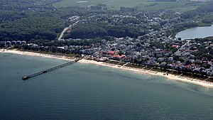
Binz
Municipality in Mecklenburg-Vorpommern, Germany
Distance: Approx. 2399 meters
Latitude and longitude: 54.4,13.6
Binz is the largest seaside resort city on the German island of Rügen. It is situated between the bay of Prorer Wiek and the Schmachter See (a lake) in the southeast of the island. To the north of Binz stretches the Schmale Heide (the "narrow heath"), a tongue of land which joins the Muttland region of Rügen to the Jasmund peninsula.

Lancken-Granitz
Municipality in Mecklenburg-Vorpommern, Germany
Distance: Approx. 1906 meters
Latitude and longitude: 54.36666667,13.63333333
Lancken-Granitz is a municipality in the Vorpommern-Rügen district, in Mecklenburg-Vorpommern, Germany. Near the villages of Lancken and Burtevitz are several megalith tombs from the Neolithic.

Schmachter See
Distance: Approx. 2232 meters
Latitude and longitude: 54.39666667,13.59694444
Schmachter See is a lake near Binz on the German Baltic Sea island of Rügen. It lies within the county of Vorpommern-Rügen in the state of Mecklenburg-Vorpommern. It has an elevation of 1.1 metres above sea level and its surface area is 1.18 km2.
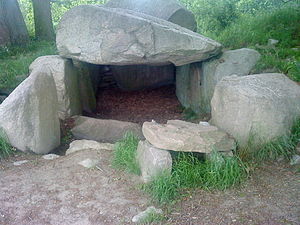
Lancken-Granitz dolmens
Megalithic tomb in Germany
Distance: Approx. 2144 meters
Latitude and longitude: 54.36286,13.61901
The Lancken-Granitz dolmens are a group of seven megalith tombs in the Lancken-Granitz municipality on Rügen, northern Germany. Erected during the middle Neolithic, when they were used by the Funnelbeaker culture, at least some were in use until the early Bronze Age. Three of them are encircled by solitary rocks forming either rectangles or a stone circle, one has a solitary "guardian stone" on its eastern side.
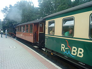
Rügen narrow-gauge railway
Distance: Approx. 643 meters
Latitude and longitude: 54.376475,13.618339
The Rügen narrow-gauge railway (German: Rügensche Bäderbahn, formerly Rügensche Kleinbahn or RüKB) – nicknamed Rasender Roland ("Raging Roland") – is a steam-powered narrow-gauge railway that runs from Putbus by way of Binz, Sellin, and Baabe to Göhren on the island of Rügen off the Baltic Coast in Mecklenburg-Vorpommern, Germany. Since 2008, it has been run by the Eisenbahn-Bau- und Betriebsgesellschaft Pressnitztalbahn mbH. There is an interchange with the island's Deutsche Bahn mainline network via the Veolia-run OLA railways. The Rasender Roland is one of the island's tourist attractions.

Ostseebad Binz station
Railway station in Binz, Germany
Distance: Approx. 2869 meters
Latitude and longitude: 54.405,13.60027778
Ostseebad Binz (German: Bahnhof Ostseebad Binz) is a terminus railway station in the town of Binz, Mecklenburg-Vorpommern, Germany. The station lies at the end of the Lietzow-Binz railway and was opened in 1939.

Granitz Hunting Lodge
Distance: Approx. 462 meters
Latitude and longitude: 54.38055556,13.62722222
Granitz Hunting Lodge (German: Jagdschloss Granitz) is located on the German island of Rügen in the vicinity of the seaside resort of Binz. With over 200,000 visitors per year it is the most popular castle or schloss in Mecklenburg-Vorpommern.

Southeast Rügen Biosphere Reserve
Distance: Approx. 4290 meters
Latitude and longitude: 54.4025,13.56444444
The Southeast Rügen Biosphere Reserve (German: Biosphärenreservat Südost-Rügen) is a biosphere reserve in the German state of Mecklenburg-Vorpommern, which covers the southeastern part of the island of Rügen (including Granitz and Mönchgut), the lagoon of Rügischer Bodden between Putbus and Thiessow, the outer coast between Thiessow and Binz and the island of Vilm. In the biosphere reserve all the classic landscape and coastal features of the Mecklenburg-Vorpommern littoral are found within one small area. The land is deeply indented here by the sea.

Granitz
Distance: Approx. 1927 meters
Latitude and longitude: 54.38695529,13.64913889
The Granitz is a wooded ridge in the southeast of Germany's largest island, Rügen, between the Baltic Sea resorts of Binz and Sellin. The woods cover an area of 982 hectares and are designated as a nature reserve. Since 1991 they have been part of the Southeast Rügen Biosphere Reserve.
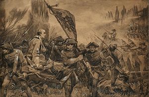
Battle of Stresow
Battle during the Great Northern War, 1715
Distance: Approx. 4473 meters
Latitude and longitude: 54.3528,13.5734
The successful Landing on Groß Stresow by Prussian, Danish and Saxon troops took place on 15 November 1715 on the island of Rügen, Germany during the Great Northern War. The landing was followed with cavalry assaults from the Swedish defences on the island, commanded by Charles XII king of Sweden who despite the huge numerical disadvantage of - one up against five - chose to attack the fortified camp. The Swedes managed to get past the "Cheval de frise" and break through, but were then rapidly repulsed and routed after taking heavy casualties.

Schmachter See and Fangerien Nature Reserve
Distance: Approx. 2354 meters
Latitude and longitude: 54.39445,13.59112
The Schmachter See and Fangerien Nature Reserve (German: Naturschutzgebiet Schmachter See und Fangerien) is a nature reserve in the German state of Mecklenburg-Western Pomerania and covers an area of 262 hectares. It was placed under conservation protection on 7 December 1994 with the goal of preserving and cultivating a section of the East Rügen hill country together with a silted lake and adjacent wet meadows, bogs and woods. The lake of Schmachter See lies immediately southwest of Binz.

Schwarzer See (Granitz)
Distance: Approx. 3479 meters
Latitude and longitude: 54.3936,13.6705
The Schwarzer See is a lake on the German Baltic Sea island of Rügen. It belongs to the municipality of Sellin and is located in the Granitz Forest. The lake has an area of 23 hectares, a greatest depth of 15 metres and the elevation of its water surface above sea level is 54.2 m above sea level (NHN).
Weather in this IP's area
overcast clouds
9 Celsius
7 Celsius
9 Celsius
9 Celsius
1006 hPa
93 %
1006 hPa
998 hPa
10000 meters
3.35 m/s
3.75 m/s
162 degree
96 %
07:20:58
18:24:42