Country:
 Poland
Region:
City:
Latitude and Longitude:
Time Zone:
Postal Code:
IP information under different IP Channel
ip-api
Country
Region
City
ASN
Time Zone
ISP
Blacklist
Proxy
Latitude
Longitude
Postal
Route
IPinfo
Country
Region
City
ASN
Time Zone
ISP
Blacklist
Proxy
Latitude
Longitude
Postal
Route
MaxMind
Country
Region
City
ASN
Time Zone
ISP
Blacklist
Proxy
Latitude
Longitude
Postal
Route
Luminati
Country
PLRegion
10
City
konstantynowlodzki
ASN
Time Zone
Europe/Warsaw
ISP
Institute of Bioorganic Chemistry Polish Academy of Science, Poznan Supercomputing and Netw
Latitude
Longitude
Postal
db-ip
Country
Region
City
ASN
Time Zone
ISP
Blacklist
Proxy
Latitude
Longitude
Postal
Route
ipdata
Country
Region
City
ASN
Time Zone
ISP
Blacklist
Proxy
Latitude
Longitude
Postal
Route
Popular places and events near this IP address
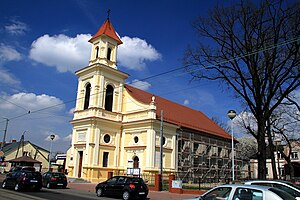
Konstantynów Łódzki
Place in Łódź Voivodeship, Poland
Distance: Approx. 555 meters
Latitude and longitude: 51.75,19.33333333
Konstantynów Łódzki [kɔnstanˈtɨnuf ˈwut͡skʲi] is a town in Pabianice County, Łódź Voivodeship, Poland, with 18,335 inhabitants (2020). It borders Łódź to the east, Lutomiersk to the west, Aleksandrów Łódzki to the north, and Porszewice to the south. It was founded in the 1820s by a landowner who had planned to build a textile industry there.

Bechcice-Wieś
Village in Łódź Voivodeship, Poland
Distance: Approx. 3358 meters
Latitude and longitude: 51.74277778,19.27805556
Bechcice-Wieś [bɛxˈt͡ɕit͡sɛ ˈvjɛɕ] is a village in the administrative district of Gmina Lutomiersk, within Pabianice County, Łódź Voivodeship, in central Poland.
Florentynów, Pabianice County
Village in Łódź Voivodeship, Poland
Distance: Approx. 3359 meters
Latitude and longitude: 51.73333333,19.28333333
Florentynów [flɔrɛnˈtɨnuf] is a village in the administrative district of Gmina Lutomiersk, within Pabianice County, Łódź Voivodeship, in central Poland. It lies approximately 7 kilometres (4 mi) east of Lutomiersk, 12 km (7 mi) north-west of Pabianice, and 14 km (9 mi) south-west of the regional capital Łódź.
Kolonia Bechcice
Village in Łódź Voivodeship, Poland
Distance: Approx. 4749 meters
Latitude and longitude: 51.74888889,19.25722222
Kolonia Bechcice [kɔˈlɔɲa bɛxˈt͡ɕit͡sɛ] is a village in the administrative district of Gmina Lutomiersk, within Pabianice County, Łódź Voivodeship, in central Poland. It lies approximately 4 kilometres (2 mi) east of Lutomiersk, 15 km (9 mi) northwest of Pabianice, and 15 km (9 mi) west of the regional capital Łódź.
Okołowice, Łódź Voivodeship
Village in Łódź Voivodeship, Poland
Distance: Approx. 1686 meters
Latitude and longitude: 51.73333333,19.33333333
Okołowice [ɔkɔwɔˈvit͡sɛ] is a village in the administrative district of Gmina Pabianice, within Pabianice County, Łódź Voivodeship, in central Poland. It lies approximately 10 kilometres (6 mi) north of Pabianice and 11 km (7 mi) south-west of the regional capital Łódź.

Porszewice
Village in Łódź Voivodeship, Poland
Distance: Approx. 3905 meters
Latitude and longitude: 51.71666667,19.3
Porszewice [pɔrʂɛˈvit͡sɛ] is a village in the administrative district of Gmina Pabianice, within Pabianice County, Łódź Voivodeship, in central Poland. It lies 10 kilometres (6 mi) north-west of Pabianice and 14 km (9 mi) south-west of the regional capital Łódź.

Świątniki, Pabianice County
Village in Łódź Voivodeship, Poland
Distance: Approx. 4944 meters
Latitude and longitude: 51.70611111,19.30138889
Świątniki (Polish pronunciation: [ɕfjɔntˈɲikʲi]) is a village in the administrative district of Gmina Pabianice, within Pabianice County, Łódź Voivodeship, in central Poland. It lies approximately 9 kilometres (6 mi) north-west of Pabianice and 15 km (9 mi) south-west of the regional capital Łódź.
Krzywiec, Łódź Voivodeship
Village in Łódź Voivodeship, Poland
Distance: Approx. 4298 meters
Latitude and longitude: 51.77916667,19.28972222
Krzywiec [ˈkʂɨvʲɛt͡s] is a village in the administrative district of Gmina Aleksandrów Łódzki, within Zgierz County, Łódź Voivodeship, in central Poland. It lies approximately 5 kilometres (3 mi) south of Aleksandrów Łódzki, 12 km (7 mi) south-west of Zgierz, and 13 km (8 mi) west of the regional capital Łódź.
Rąbień
Village in Łódź Voivodeship, Poland
Distance: Approx. 4009 meters
Latitude and longitude: 51.78333333,19.31666667
Rąbień [ˈrɔmbʲɛɲ] is a village in the administrative district of Gmina Aleksandrów Łódzki, within Zgierz County, Łódź Voivodeship, in central Poland. It lies approximately 4 kilometres (2 mi) south of Aleksandrów Łódzki, 11 km (7 mi) south-west of Zgierz, and 11 km (7 mi) west of the regional capital Łódź.
Rąbień AB
Village in Łódź Voivodeship, Poland
Distance: Approx. 4772 meters
Latitude and longitude: 51.78722222,19.29888889
Rąbień AB is a village in the administrative district of Gmina Aleksandrów Łódzki, within Zgierz County, Łódź Voivodeship, in central Poland. It lies approximately 4 kilometres (2 mi) south of Aleksandrów Łódzki, 11 km (7 mi) south-west of Zgierz, and 12 km (7 mi) west of the regional capital Łódź.

Łódź Lublinek railway station
Railway station in Łódź, Poland
Distance: Approx. 3781 meters
Latitude and longitude: 51.72083333,19.35944444
Łódź Lublinek (formerly Lublinek) is a small traffic railway station located on the outskirts of Łódź, Poland, in Polesie district, approx. 9 km from the city center, and in the direct vicinity of Łódź Władysław Reymont Airport. The station was created in the early 1940s by Germans as part of the wartime Program Otto, rebuilding the existing site of the railway crossing site into a pre-interchange stopping point.

Dobrzynka (river)
River in Poland
Distance: Approx. 4387 meters
Latitude and longitude: 51.71305,19.35611
Dobrzynka - is a river in Poland with an approximate length of 25.5 km. The river flows on the Łódź Upland. The sources of the river are located at an altitude of 250 m above sea level in the village of Górki Duże near Tuszyn.
Weather in this IP's area
clear sky
8 Celsius
7 Celsius
7 Celsius
9 Celsius
1025 hPa
68 %
1025 hPa
1004 hPa
10000 meters
1.79 m/s
8.49 m/s
161 degree
07:14:10
17:40:43