Country:
 Turkey
Region:
City:
Latitude and Longitude:
Time Zone:
Postal Code:
IP information under different IP Channel
ip-api
Country
Region
City
ASN
Time Zone
ISP
Blacklist
Proxy
Latitude
Longitude
Postal
Route
IPinfo
Country
Region
City
ASN
Time Zone
ISP
Blacklist
Proxy
Latitude
Longitude
Postal
Route
MaxMind
Country
Region
City
ASN
Time Zone
ISP
Blacklist
Proxy
Latitude
Longitude
Postal
Route
Luminati
Country
TRRegion
16
City
bursa
ASN
Time Zone
Europe/Istanbul
ISP
Vodafone Net Iletisim Hizmetler AS
Latitude
Longitude
Postal
db-ip
Country
Region
City
ASN
Time Zone
ISP
Blacklist
Proxy
Latitude
Longitude
Postal
Route
ipdata
Country
Region
City
ASN
Time Zone
ISP
Blacklist
Proxy
Latitude
Longitude
Postal
Route
Popular places and events near this IP address

Osmangazi
District and municipality in Bursa, Turkey
Distance: Approx. 3274 meters
Latitude and longitude: 40.19833333,29.06
Osmangazi is a municipality and district of Bursa Province, Turkey. Its area is 621 km2, and its population is 891,250 (2022). It is one of the central metropolitan districts of the city of Bursa, as well as the fourth largest overall municipality in Turkey.
Bursa Atatürk Sport Hall
Distance: Approx. 4098 meters
Latitude and longitude: 40.19423,29.04839
Bursa Atatürk Sport Hall (Turkish: Bursa Atatürk Spor Salonu) is a multi-purpose indoor sport venue located in the district of Altıparmak, Osmangazi in Bursa, Turkey. The hall, with a capacity for 3,000 people, was built in 1972. Home of four clubs Bursaspor Basketbol, Oyak Renault Basketball, Yeşim SK and Uludağ Üniversitesi SK, it is the biggest indoor sport hall in Bursa, where competitions of basketball, volleyball and handball are held.
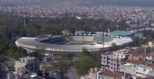
Bursa Atatürk Stadium
Turkish football stadium
Distance: Approx. 4238 meters
Latitude and longitude: 40.19264722,29.04875556
Bursa Atatürk Stadium (Turkish: Bursa Atatürk Stadyumu) was a multi-purpose stadium in Bursa, Turkey. It was used mostly for football matches and was the home ground of Bursaspor. The stadium held 25,213 and was built in 1979.

Bayezid I Mosque
Mosque in Bursa, Turkey
Distance: Approx. 4394 meters
Latitude and longitude: 40.1875,29.0825
Bayezid I Mosque (Turkish: Yıldırım Camii or Yıldırım Bayezid Camii) is a historic mosque in Bursa, Turkey, that is part of the large complex (külliye) built by the Ottoman Sultan Bayezid I (Yıldırım Bayezid – Bayezid the Thunderbolt) between 1391–1395. It is situated in Bursa metropolitan district of Yıldırım, also named after the same sultan. It underwent extensive renovation following the 1855 Bursa earthquake.
1855 Bursa earthquake
Destructive 1855 earthquake in Bursa, Turkey
Distance: Approx. 3748 meters
Latitude and longitude: 40.2,29.1
The 1855 Bursa earthquake occurred on 28 February, with an estimated magnitude of 7.02±0.64 Mw A devastating precursor quake that took place in Mustafakemalpaşa, a town of Bursa Province, in Turkey caused severe destruction all over Bursa and other neighboring cities. 300 people died and thousands of homes and workplaces were wrecked, and some of the historical monuments and buildings including mosques collapsed. Subsequently, fire spread out in the city, which increased the death toll.
Mayor Synagogue (Bursa)
Former synagogue in Bursa, Turkey
Distance: Approx. 1682 meters
Latitude and longitude: 40.2292,29.0917
The Mayor Synagogue (Turkish: Sinagoga Mayor), or Synagogue Mejor, is a former Jewish congregation and synagogue located on Arap Şükrü (Sakarya) Street in Bursa, Turkey. No longer used as a synagogue, the building is used as a mikveh.

Bursa Archaeological Museum
Archaeology museum in Çekirge, Bursa
Distance: Approx. 4296 meters
Latitude and longitude: 40.19583333,29.04111111
Bursa Archaeological Museum (Turkish: Bursa Arkeoloji Müzesi), shortly Bursa Museum, is a national museum in Bursa, Turkey, exhibiting archaeological artifacts found in and around the province.

Bursa Atatürk Museum
Historic house museum in Osmangazi, Bursa Turkey
Distance: Approx. 4428 meters
Latitude and longitude: 40.195,29.04
Bursa Atatürk Museum (Turkish: Bursa Atatürk Evi Müzesi) is a historic house museum in Bursa, Turkey. The museum is at 40°11′42″N 29°02′24″E at Çekirge quarter of Osmangazi district in Bursa Province. The museum is a three-storey house.
Bursa Forestry Museum
Distance: Approx. 4447 meters
Latitude and longitude: 40.1999,29.032928
Bursa Forestry Museum (Turkish: Bursa Ormancılık Müzesi) is a museum in Bursa, northwestern Turkey dedicated to forestry. Opened in 1989, it is housed in a historic Ottoman era mansion. Its collection size is nearly 1,000 items.
Basilica Therma (Bithynia)
Town of ancient Bithynia
Distance: Approx. 3392 meters
Latitude and longitude: 40.205714,29.042755
Basilica Therma was a town located of ancient Bithynia, near Prusa. Its site is located near Çekirge, Asiatic Turkey.
Bursa Sports High School
School in Turkey
Distance: Approx. 2505 meters
Latitude and longitude: 40.20633,29.08612
Bursa Sports High School (Turkish: Bursa Spor Lisesi), full name Bursa BTSO Celal Sönmez Spor Lisesi (BTSO is for Bursa Commerce and Industry Chamber), is a government-funded co-educational comprehensive and specialist secondary school, with speciality in sports, located in Osmangazi district of Bursa Province, Turkey. The high school has been serving in this status since 2006.
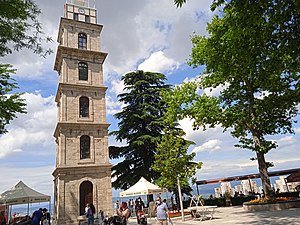
Tophane Clock Tower
Distance: Approx. 4480 meters
Latitude and longitude: 40.18756,29.05755
The Tophane Clock Tower (Turkish: Tophane Saat Kulesi) is a clock tower in Bursa, Turkey. It has six floors and is 33m in height. The tower currently has a radio clock and is used as a fire lookout station.
Weather in this IP's area
scattered clouds
16 Celsius
15 Celsius
16 Celsius
16 Celsius
1024 hPa
47 %
1024 hPa
1013 hPa
10000 meters
4.18 m/s
4.44 m/s
35 degree
34 %
07:17:36
18:19:42