Country:
 Turkey
Region:
City:
Latitude and Longitude:
Time Zone:
Postal Code:
IP information under different IP Channel
ip-api
Country
Region
City
ASN
Time Zone
ISP
Blacklist
Proxy
Latitude
Longitude
Postal
Route
IPinfo
Country
Region
City
ASN
Time Zone
ISP
Blacklist
Proxy
Latitude
Longitude
Postal
Route
MaxMind
Country
Region
City
ASN
Time Zone
ISP
Blacklist
Proxy
Latitude
Longitude
Postal
Route
Luminati
Country
TRASN
Time Zone
Europe/Istanbul
ISP
Star of Bosphorus Bilgi Teknolojiler San ve Tic A.S.
Latitude
Longitude
Postal
db-ip
Country
Region
City
ASN
Time Zone
ISP
Blacklist
Proxy
Latitude
Longitude
Postal
Route
ipdata
Country
Region
City
ASN
Time Zone
ISP
Blacklist
Proxy
Latitude
Longitude
Postal
Route
Popular places and events near this IP address

Galleria Ataköy
Shopping mall in Ataköy, Istanbul
Distance: Approx. 842 meters
Latitude and longitude: 40.97444444,28.86972222
Galleria Ataköy, the first modern shopping mall in Turkey, is situated in the western suburb of Ataköy, Istanbul. It was built following the recommendation of then Prime Minister Turgut Özal, who was inspired by the shopping mall Houston Galleria in Houston, Texas, United States. Galleria Ataköy was opened in 1988 by Turgut Özal.

Carousel Shopping Center
A shopping mall in Bakırköy, Istanbul
Distance: Approx. 353 meters
Latitude and longitude: 40.97805556,28.87388889
Carousel Shopping Center (Turkish: Carousel Alışveriş ve Yaşam Merkezi), opened in 1995, is a modern shopping mall located in the Bakırköy district of Istanbul, Turkey. The shopping center with its 76,500 m² area has 117 shops, fast food restaurants, cafeterias, entertainment center and movie theaters. There are 7 elevators and 12 escalators providing easy access to 1.5 million visitors monthly.
Etz Ahayim Synagogue
Synagogue in Istanbul, Turkey
Distance: Approx. 597 meters
Latitude and longitude: 40.97828472,28.87092245
The Etz Ahayim Synagogue (Hebrew: קהל קדוש עץ החיים), also known as the Beit Yaakov Synagogue or the Ortaköy Synagogue, is a Jewish congregation and synagogue, located on Icadiye Street, in Kuzguncuk, Ortaköy, on the coast near the right leg of Bosphorus Bridge, in Istanbul, in the Istanbul Province of Turkey. It is unknown when the original synagogue was built, but it is estimated to be before 1703. The building also housed an academy for over one hundred years.
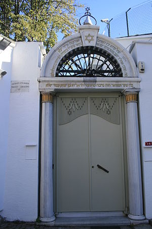
Bakırköy Synagogue
Synagogue in Istanbul, Turkey
Distance: Approx. 597 meters
Latitude and longitude: 40.97828472,28.87092245
The Bakırköy Synagogue is a Jewish congregation and synagogue, located on Cumhuriyet Avenue, in Bakırköy, Istanbul, in the Istanbul Province of Turkey. Completed in the early 20th century, the synagogue is open, yet only open for Shabbat services. Established in 1914 by Sephardic Jews from Edirne through the efforts of Moshe Pinhas and Moshe Behar Hak, during World War II the synagogues was used for profane purposes, and then returned to the Jewish community after the war.

Galleria Ice Rink
Distance: Approx. 842 meters
Latitude and longitude: 40.97444444,28.86972222
Galleria Ice Rink (Turkish: Galleria Buz Pisti) is an indoor ice skating and ice hockey rink located within the Galleria Ataköy shopping center located in Bakırköy district of Istanbul, Turkey. It was opened in 1989. The rink is run by the company "Galleria Buz Pateni Pisti", a subsidiary of the shopping mall.

Veliefendi Race Course
Horse racing track in Istanbul, Turkey
Distance: Approx. 1303 meters
Latitude and longitude: 40.98709,28.88881
Veliefendi Race Course (Turkish: Veliefendi Hipodromu) is a horse racing track located at Veliefendi neighborhood in Bakırköy district of Istanbul, Turkey. It is the country's oldest and biggest race course founded on a former grassland that was historically a farm belonging to Şeyhülislam Veliyyüddin Efendi, an 18th-century superior authority of Islam in the Ottoman Empire. The race course was constructed in the years 1912/13 by German specialists upon the initiative of Enver Pasha.
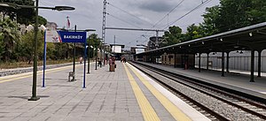
Bakırköy railway station
Railway station in Bakırköy, Istanbul, Turkey
Distance: Approx. 527 meters
Latitude and longitude: 40.980374,28.872133
Bakırköy railway station (Turkish: Bakırköy istasyonu) is the main railway station in Bakırköy, Istanbul. Located 12.6 km (7.8 mi) west of Sirkeci station, the station was serviced by Istanbul suburban commuter trains as well as TCDD regional trains to Kapıkule, Çerkezköy and Uzunköprü. The station was closed in March 2013 and subsequently demolished to make way for a larger, more modern station as part of the Marmaray project.
Rhesion
Town in ancient Thrace
Distance: Approx. 1333 meters
Latitude and longitude: 40.984296,28.892028
Rhesion was a town of ancient Thrace, inhabited during Byzantine times. Its site is located near Çobanayazma in European Turkey.
Ammoi
Town of ancient Thrace
Distance: Approx. 586 meters
Latitude and longitude: 40.980169,28.884702
Ammoi was a town of ancient Thrace, inhabited during Byzantine times. Its site is located east of Bakırköy in European Turkey.
Kampos (Thrace)
Town of ancient Thrace
Distance: Approx. 519 meters
Latitude and longitude: 40.983338,28.878683
Kampos was a town of ancient Thrace, inhabited during Byzantine times. Its site is located near Veliefendi in European Turkey.

Özgürlük Meydanı (Istanbul Metro)
Station of the Istanbul Metro
Distance: Approx. 461 meters
Latitude and longitude: 40.981667,28.874167
Özgürlük Meydanı is an underground station on the M3 line of the Istanbul Metro. It is located under İncirli Street at Bakırköy Liberty Square in the Kartaltepe neighbourhood of Bakırköy. It was opened on 10 March 2024, with the opening of the M3 extension from Kirazlı to Bakırköy Sahil.

Bakırköy Sahil (Istanbul Metro)
Station of the Istanbul Metro
Distance: Approx. 1029 meters
Latitude and longitude: 40.973611,28.867778
Bakırköy Sahil is an underground station on the M3 line of the Istanbul Metro. It is located under Galleria Inner Road at Galleria Ataköy in the Ataköy 1. kısım neighbourhood of Bakırköy.
Weather in this IP's area
scattered clouds
15 Celsius
14 Celsius
15 Celsius
16 Celsius
1025 hPa
50 %
1025 hPa
1023 hPa
10000 meters
5.14 m/s
360 degree
40 %
07:19:13
18:19:38