Country:
Region:
City:
Latitude and Longitude:
Time Zone:
Postal Code:
IP information under different IP Channel
ip-api
Country
Region
City
ASN
Time Zone
ISP
Blacklist
Proxy
Latitude
Longitude
Postal
Route
Luminati
Country
Region
32
City
szczecin
ASN
Time Zone
Europe/Warsaw
ISP
Zachodniopomorski Uniwersytet Technologiczny w Szczecinie, Akademickie Centrum Informatyki
Latitude
Longitude
Postal
IPinfo
Country
Region
City
ASN
Time Zone
ISP
Blacklist
Proxy
Latitude
Longitude
Postal
Route
db-ip
Country
Region
City
ASN
Time Zone
ISP
Blacklist
Proxy
Latitude
Longitude
Postal
Route
ipdata
Country
Region
City
ASN
Time Zone
ISP
Blacklist
Proxy
Latitude
Longitude
Postal
Route
Popular places and events near this IP address
Old Town, Szczecin
Municipal neighbourhood in Szczecin, West Pomeranian Voivodeship, Poland
Distance: Approx. 568 meters
Latitude and longitude: 53.4284,14.5599
Old Town (Polish: Stare Miasto; German: Altstadt) is a municipal neighbourhood of the city of Szczecin, Poland, situated on the left bank of the Oder river. It is the oldest historical district in the city. As of March 2021 it had a population of 3,901.

Szczecin National Museum
National museum in Szczecin, Poland
Distance: Approx. 434 meters
Latitude and longitude: 53.43,14.5648
The Szczecin National Museum (Polish: Muzeum Narodowe w Szczecinie) is a national museum in Szczecin, Poland, established on 1 August 1945. The museum features ancient and modern art, archaeological, historical, numismatic, nautical and ethnographic collections and is divided into six branches, five located in Szczecin and one in Gryfice.

Szczecin Voivodeship Office
Building in Szczecin, Poland
Distance: Approx. 374 meters
Latitude and longitude: 53.43138889,14.56611111
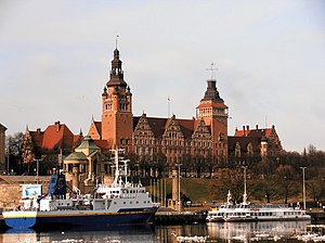
Szczecin Voivodeship Office is a historic administrative building opened in 1911, located at the Chrobry Embankment in city of Szczecin, Poland.

Maritime University of Szczecin
Distance: Approx. 548 meters
Latitude and longitude: 53.42861389,14.56356389
The Maritime University of Szczecin (Polish: Politechnika Morska w Szczecinie; Akademia Morska until 2022) is a public institute of technology in Szczecin, Poland. The profile of the institute of technology is maritime education. The Institute of Technology structure: Faculty of Navigation Faculty of Maritime Engineering Faculty of Economics and Transport Engineering Faculty of Mechatronics and Electrical Engineering Faculty of Computer Science and Telecommunications The structure of the University also includes: Centre for Maritime Technology Transfer International Students & Mobility Office.

Pazim
Skyscraper in Szczecin, Poland
Distance: Approx. 390 meters
Latitude and longitude: 53.43225556,14.55604722
Pazim, also known as Pazim Center, is a skyscraper in Szczecin, Poland. The building is located in the neighbourhood of Centrum, at 8 Rodło Square, at the intersection of Wyzwolenia Avenue and Piłsudskiego Street. It has the height to the roof of 92 m, and total height, including its radio mast, of 128 m, making it respectively the third tallest, and the tallest building in the city, depending on definition.

Galaxy (shopping centre)
Shopping centre in Szczecin
Distance: Approx. 410 meters
Latitude and longitude: 53.434,14.5555
Galaxy is a shopping centre in the city of Szczecin, Poland, that is located at 18-20 Wyzwolenia Avenue next to the intersection with Malczewskiego Street, and near the Pazim building. It is owned by Echo Investment and was opened in 2003.

Rodło Square
Urban square in Szczecin, Poland
Distance: Approx. 467 meters
Latitude and longitude: 53.43194444,14.555
The Rodło Square (Polish: Plac Rodła) is an urban square in Szczecin, Poland. It is located in the neighbourhood of Centrum, within the district of Śródmieście, at the intersection of Wyzwolenia Avenue, and Piłsudskiego Street. It was constructed in the 1970s.

French Reformed Church Cemetery
Distance: Approx. 445 meters
Latitude and longitude: 53.43254444,14.56816111
The French Reformed Church Cemetery, after 1945 known as the Żabikowo Cemetery, was a Reformed Christian cemetery in Szczecin, Poland used by the French community. It was located between current Storrady Street, Wawelska Street, Parkowa Street, and Kapitańska Street, in what now forms part of the Stefan Żeromski Park. The cemetery was founded in the first part of the 18th-century, and remained operational until 1937, and was eventually demolished in 1965.

Grabowo Cemetery
Former cemetery in Szczecin, Poland
Distance: Approx. 336 meters
Latitude and longitude: 53.43333333,14.56666667
The Grabowo Cemetery was a cemetery in Szczecin, Poland, located in the neighbourhoods of Old Town and Drzetowo-Grabowo, between Matejki, Malczewskiego, Wawelska, Starzyńskiego, and Zygmunta Starego, Paska, and Parkowa Streets. It was opened in 1802 and operated until 1910, when it was turned into the Grabowo Gardens (now known as the Stefan Żeromski Park), and most of the gravestones were removed, although some of the most historical importance were preserved until the 1950s. The graves themselves were never exhumated.

Stefan Żeromski Park (Szczecin)
Urban park in Szczecin, Poland
Distance: Approx. 60 meters
Latitude and longitude: 53.43333333,14.5625
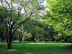
The Stefan Żeromski Park, until 1945 known as the Grabowo Gardens, is an urban park in Szczecin, Poland. It is located in the Old Town neighborhood, within the Downtown district, between Matejki, Malczewskiego, Parkowa, Kapitańska, Storrady, Wawelska, Starzyńskiego, and Zygmunta Starego Streets. With an area of 21.97 ha, it is the second largest park in the city.
Adam Mickiewicz Monument (Szczecin)
Monument in Szczecin, Poland
Distance: Approx. 255 meters
Latitude and longitude: 53.43111111,14.56175833
The Adam Mickiewicz Monument (Polish: Pomnik Adama Mickiewicza) is a monument in Szczecin, Poland, located at the Mickiewicz Square near the Stefan Żeromski Park. It consists of a concrete statue of Adam Mickiewicz, a 19th-century poet, writer, and political activist. It was designed by Sławomir Lewiński and unveiled on 3 May 1960.
Stanisław Nadratowski Park
Urban park in Szczecin, Poland
Distance: Approx. 501 meters
Latitude and longitude: 53.43670278,14.56674167
The Stanisław Nadratowski Park is an urban park in Szczecin, Poland. It is located in the Drzetowo-Grabowo neighborhood, within the Downtown district, between Malczewskiego, Kazimierza, Plater, and Parkowa Streets. It was established in 1910, in place of the former Grabowo Cemetery.
Weather in this IP's area
overcast clouds
6 Celsius
2 Celsius
4 Celsius
6 Celsius
1003 hPa
75 %
1003 hPa
1000 hPa
10000 meters
5.81 m/s
10.73 m/s
230 degree
94 %
07:33:16
16:01:00

