212.14.143.24 - IP Lookup: Free IP Address Lookup, Postal Code Lookup, IP Location Lookup, IP ASN, Public IP
Country:
Region:
City:
Location:
Time Zone:
Postal Code:
ISP:
ASN:
language:
User-Agent:
Proxy IP:
Blacklist:
IP information under different IP Channel
ip-api
Country
Region
City
ASN
Time Zone
ISP
Blacklist
Proxy
Latitude
Longitude
Postal
Route
db-ip
Country
Region
City
ASN
Time Zone
ISP
Blacklist
Proxy
Latitude
Longitude
Postal
Route
IPinfo
Country
Region
City
ASN
Time Zone
ISP
Blacklist
Proxy
Latitude
Longitude
Postal
Route
IP2Location
212.14.143.24Country
Region
lazio
City
rome
Time Zone
Europe/Rome
ISP
Language
User-Agent
Latitude
Longitude
Postal
ipdata
Country
Region
City
ASN
Time Zone
ISP
Blacklist
Proxy
Latitude
Longitude
Postal
Route
Popular places and events near this IP address

Mamertine Prison
Roman historical prison
Distance: Approx. 108 meters
Latitude and longitude: 41.89333333,12.48444444
The Mamertine Prison (Italian: Carcere Mamertino), in antiquity the Tullianum, was a prison (carcer) with a dungeon (oubliette) located in the Comitium in ancient Rome. It is said to have been built in the 7th century BC and was situated on the northeastern slope of the Capitoline Hill, facing the Curia and the imperial forums of Nerva, Vespasian, and Augustus. Located between it and the Tabularium (record house) were the Gemonian stairs leading to the Arx of the Capitoline.

Gemonian stairs
Historic location in Rome
Distance: Approx. 113 meters
Latitude and longitude: 41.89333333,12.48472222
The Gemonian Stairs (Latin: Scalae Gemoniae, Italian: Scale Gemonie) were a flight of steps located in the ancient city of Rome. Nicknamed the Stairs of Mourning, the stairs are infamous in Roman history as a place of execution.

Imperial fora
Series of monumental squares in Rome
Distance: Approx. 105 meters
Latitude and longitude: 41.89444444,12.48555556
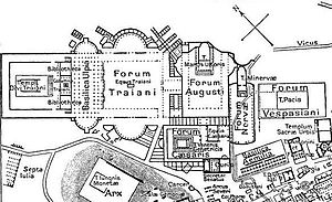
The Imperial Fora (Fori Imperiali in Italian) are a series of monumental fora (public squares), constructed in Rome over a period of one and a half centuries, between 46 BC and 113 AD. The fora were the center of the Roman Republic and of the Roman Empire. The Imperial Fora, while not part of the Roman Forum, are located relatively close to each other. Julius Caesar was the first to build in this section of Rome and rearranged both the Forum and the Comitium, another forum type space designated for politics, to do so.

Victor Emmanuel II Monument
Building in Rome, Italy
Distance: Approx. 113 meters
Latitude and longitude: 41.89472222,12.48305556
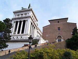
The Victor Emmanuel II National Monument (Italian: Monumento Nazionale a Vittorio Emanuele II), also known as the Vittoriano or Altare della Patria ("Altar of the Fatherland"), is a large national monument built between 1885 and 1935 to honour Victor Emmanuel II, the first king of a unified Italy, in Rome, Italy. It occupies a site between the Piazza Venezia and the Capitoline Hill. The monument was realized by Giuseppe Sacconi.

Santa Maria in Ara Coeli
Roman Catholic basilica, a landmark of Rome, Italy
Distance: Approx. 94 meters
Latitude and longitude: 41.8939,12.4833
The Basilica of Saint Mary of the Altar in Heaven (Latin: Basilica Sanctae Mariae de Ara Cœli in Capitolio, Italian: Basilica di Santa Maria in Ara Cœli al Campidoglio) is a titular basilica and conventual church of the Franciscan Convent of Aracoeli located the highest summit of the Capitoline Hill in Rome, Italy. From 1250-1798 it was the headquarters of the General Curia of the Order of Friars Minor as well as being one of the city's principal civic churches. It is still the designated church of the city council of Rome, which uses the ancient title of Senatus Populusque Romanus.

Temple of Venus Genetrix
Roman temple (46 BCE)
Distance: Approx. 43 meters
Latitude and longitude: 41.8942,12.4848
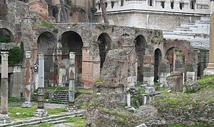
The Temple of Venus Genetrix (Latin: Templum Veneris Genetricis) is a ruined temple in the Forum of Caesar, Rome, dedicated to the Roman goddess Venus Genetrix, the founding goddess of the Julian gens. It was dedicated to the goddess on 26 September 46 BCE by Julius Caesar.

Forum of Caesar
Ancient Roman imperial forum, a landmark of Rome, Italy
Distance: Approx. 62 meters
Latitude and longitude: 41.89401111,12.48493889
The Forum of Caesar, also known by the Latin Forum Iulium or Forum Julium, Forum Caesaris, was a forum built by Julius Caesar near the Forum Romanum in Rome in 46 BC.

Bufalini Chapel
Church in Rome, Italy
Distance: Approx. 130 meters
Latitude and longitude: 41.89376944,12.48290556
The Bufalini Chapel is a side chapel of the church of Santa Maria in Aracoeli, Rome, Italy. The first chapel on the right after the entrance, it houses a cycle of frescoes executed c. 1484-1486 by Pinturicchio depicting the life of the Franciscan friar St.

Temple of Juno Moneta
Distance: Approx. 122 meters
Latitude and longitude: 41.89333333,12.48361111
The Temple of Juno Moneta (Latin: Templum Iunonis Monetæ) was an ancient Roman temple that stood on the Arx or the citadel on the Capitoline Hill overlooking the Roman Forum. Located at the center of the city of Rome, it was next to the place where Roman coins were first minted, and probably stored the metal and coins involved in this process, thereby initiating the ancient practice of associating mints with temples. In addition, it was the place where the books of the magistrates were deposited.

Porta Fontinalis
Distance: Approx. 33 meters
Latitude and longitude: 41.894,12.4843
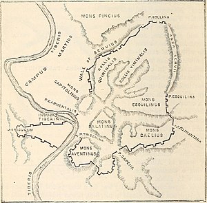
The Porta Fontinalis was a gate in the Servian Wall in ancient Rome. It was located on the northern slope of the Capitoline Hill, probably the northeast shoulder over the Clivus Argentarius. The Via Salaria exited through it, as did the Via Flaminia originally, providing a direct link with Picene and Gallic territory.

Basilica Argentaria
Distance: Approx. 25 meters
Latitude and longitude: 41.894094,12.484411
The Basilica Argentaria is a portico with pillars lining the Temple of Venus Genetrix in the Forum of Caesar in Rome (Italy). The name only appears in late sources of the age of Constantine.

Basilica Porcia
Distance: Approx. 119 meters
Latitude and longitude: 41.8933,12.4848
The Basilica Porcia was the first civil basilica built in ancient Rome. It was built by order of Marcus Porcius Cato in 184 BC as censor and is named after him. He built it as a space for administering laws and for merchants to meet, against some opposition.
Weather in this IP's area
clear sky
12 Celsius
11 Celsius
11 Celsius
13 Celsius
1019 hPa
75 %
1019 hPa
1011 hPa
10000 meters
3.6 m/s
160 degree