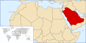
Country:
Region:
City:
Latitude and Longitude:
Time Zone:
Postal Code:
IP information under different IP Channel
ip-api
Country
Region
City
ASN
Time Zone
ISP
Blacklist
Proxy
Latitude
Longitude
Postal
Route
Luminati
Country
Region
11
City
albahah
ASN
Time Zone
Asia/Riyadh
ISP
King Abdul Aziz City for Science and Technology
Latitude
Longitude
Postal
IPinfo
Country
Region
City
ASN
Time Zone
ISP
Blacklist
Proxy
Latitude
Longitude
Postal
Route
db-ip
Country
Region
City
ASN
Time Zone
ISP
Blacklist
Proxy
Latitude
Longitude
Postal
Route
ipdata
Country
Region
City
ASN
Time Zone
ISP
Blacklist
Proxy
Latitude
Longitude
Postal
Route
Popular places and events near this IP address

Al-Bahah Province
Administrative region of Saudi Arabia
Distance: Approx. 2842 meters
Latitude and longitude: 20,41.5
Al-Bahah Province (Arabic: ٱلْبَاحَة al-Bāḥah pronounced [alˈbaːħa]) is a province of Saudi Arabia. It is located in the southwestern part of the Hejazi region. It has an area of 9,921 km2, and a population of 339,174 (2022).

Al Bahah
Place in Al-Bahah, Saudi Arabia
Distance: Approx. 1054 meters
Latitude and longitude: 20.0125,41.46527778
Al Baha (Arabic: ٱلْبَاحَة, Al-Bāḥa) is a city in south western Saudi Arabia located in the Sarawat Mountains. It is the capital of Al Bahah Region, and is one of the Kingdom's prime tourist attractions. It enjoys a pleasant climate and is surrounded by more than forty forests, including Raghdan, Al-Zaraeb and Baidan.
Al Baha University
University in Saudi Arabia
Distance: Approx. 1939 meters
Latitude and longitude: 19.99444444,41.48333333
Albaha University is a university in Al Baha city, the capital of Al Baha province, Saudi Arabia. It is a public university that was founded in 2006. The president of the university is Prof.
Al-Ain FC (Saudi Arabia)
Association football club in Saudi Arabia
Distance: Approx. 9320 meters
Latitude and longitude: 20.08063889,41.52283333
Al-Ain Saudi Football Club (Arabic: نادي العين السعودي) is a Saudi Arabian professional association football club based in Al Atawlah, Al Qara, Al Bahah. The club was founded in 1978 and play their home matches at the King Saud Sport City Stadium. The team competes in the First Division League, the second tier of Saudi football.

Jabal Lawa's
Distance: Approx. 7427 meters
Latitude and longitude: 20.04166667,41.4125
Jabal Lawa's (Arabic: جبل لوعس), also known as Mount Loess, is a mountain in Saudi Arabia. It is 2,558 m (8,392 ft) high, and is located in a sub-range of the Sarawat mountain range, near the city of Al Bahah in the Al Bahah Region.
Beda Dam
Dam in Al Bahah, Saudi Arabia
Distance: Approx. 2842 meters
Latitude and longitude: 20,41.5
The Beda dam is a dam in Saudi Arabia opened in 1985 and located in Al Baha region.
Dhuaian Dam
Dam in Al Baha, Saudi Arabia
Distance: Approx. 2842 meters
Latitude and longitude: 20,41.5
The Dhuaian dam is a dam in Saudi Arabia opened in 2000 and located in Al Baha region.
Marzoq Dam
Dam in Baha, Saudi Arabia
Distance: Approx. 2842 meters
Latitude and longitude: 20,41.5
The Marzoq dam is a dam in Saudi Arabia opened in 1987 and located in Baha region.
Marbaa Dam
Dam in Baha
Distance: Approx. 2842 meters
Latitude and longitude: 20,41.5
The Marbaa dam is a dam in Saudi Arabia opened in 1984 and located in Baha region.
Maslah Dam
Dam in Baha
Distance: Approx. 2842 meters
Latitude and longitude: 20,41.5
The Maslah dam is a dam in Saudi Arabia opened in 1984 and located in Baha region. The main purpose of the dam is flood control.
King Saud Sport City Stadium
Sport City at alBaha region, Saudi Arabia
Distance: Approx. 9429 meters
Latitude and longitude: 20.08083333,41.52444444
King Saud Sports City (Arabic: مَدِيْنَة ٱلْمَلِك سُعُوْد ٱلرِّيَاضِيَّة, romanized: Madīnat Al-Malik Suʿūd Ar-Riyāḍiyyah) is a multi-use Saudi sports facility which is located in the city of Al-Bahah.
Weather in this IP's area
few clouds
22 Celsius
22 Celsius
22 Celsius
22 Celsius
1017 hPa
66 %
1017 hPa
795 hPa
10000 meters
1.1 m/s
1.4 m/s
212 degree
16 %
06:18:08
17:37:21