Country:
 Poland
Region:
City:
Latitude and Longitude:
Time Zone:
Postal Code:
IP information under different IP Channel
ip-api
Country
Region
City
ASN
Time Zone
ISP
Blacklist
Proxy
Latitude
Longitude
Postal
Route
IPinfo
Country
Region
City
ASN
Time Zone
ISP
Blacklist
Proxy
Latitude
Longitude
Postal
Route
MaxMind
Country
Region
City
ASN
Time Zone
ISP
Blacklist
Proxy
Latitude
Longitude
Postal
Route
Luminati
Country
PLRegion
02
City
wroclaw
ASN
Time Zone
Europe/Warsaw
ISP
Korbank S. A.
Latitude
Longitude
Postal
db-ip
Country
Region
City
ASN
Time Zone
ISP
Blacklist
Proxy
Latitude
Longitude
Postal
Route
ipdata
Country
Region
City
ASN
Time Zone
ISP
Blacklist
Proxy
Latitude
Longitude
Postal
Route
Popular places and events near this IP address

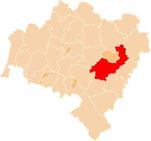
Lower Silesian Voivodeship
Voivodeship of Poland
Distance: Approx. 591 meters
Latitude and longitude: 51.11666667,17.03333333
Lower Silesian Voivodeship (Polish: Województwo dolnośląskie, [vɔjɛˈvut͡stfɔ dɔlnɔˈɕlɔ̃skjɛ] ) in southwestern Poland, is one of the 16 voivodeships (provinces) into which Poland is divided. It covers an area of 19,946 square kilometres (7,701 sq mi), and as of 2019 has a total population of 2,899,986. It is one of the wealthiest provinces in Poland as natural resources such as copper, brown coal and rock materials are widely present.

Province of Silesia
Province of Prussia (1815–1919)
Distance: Approx. 591 meters
Latitude and longitude: 51.11666667,17.03333333
The Province of Silesia (German: Provinz Schlesien; Polish: Prowincja Śląska; Silesian: Prowincyjŏ Ślōnskŏ) was a province of Prussia from 1815 to 1919. The Silesia region was part of the Prussian realm since 1742 and established as an official province in 1815, then became part of the German Empire in 1871. In 1919, as part of the Free State of Prussia within Weimar Germany, Silesia was divided into the provinces of Upper Silesia and Lower Silesia.

Wrocław Voivodeship (1975–1998)
Distance: Approx. 591 meters
Latitude and longitude: 51.116667,17.033333
Wrocław Voivodeship (Polish: województwo wrocławskie) was a voivodeship (province) of Poland that existed from 1975 until 31 December 1998, when it was absorbed into the larger Lower Silesian Voivodeship.
Wrocław County
County in Lower Silesian Voivodeship, Poland
Distance: Approx. 591 meters
Latitude and longitude: 51.11666667,17.03333333
Wrocław County (Polish: powiat wrocławski) is a unit of territorial administration and local government (powiat) in Lower Silesian Voivodeship, south-western Poland. It came into being on January 1, 1999, as a result of the Polish local government reforms passed in 1998. The county covers an area of 1,116 square kilometres (431 sq mi).

Battle of Breslau (1757)
1757 battle during the Third Silesian War
Distance: Approx. 587 meters
Latitude and longitude: 51.1167,17.0333
The Battle of Breslau (also known as the Battle on the Lohe) was fought on 22 November 1757 in Breslau (now Wrocław, Poland) during the Third Silesian War (part of the Seven Years' War). A Prussian army of 28,000 men fought an Austrian army of 60,000 men. The Prussians held off the Austrian attack, losing 6,000 men to the Austrians' 5,000 men.

University of Wrocław
Public university in Wrocław, Poland
Distance: Approx. 810 meters
Latitude and longitude: 51.11361111,17.03333333
The University of Wrocław (Polish: Uniwersytet Wrocławski, UWr; Latin: Universitas Wratislaviensis) is a public research university in Wrocław, Poland. It is the largest institution of higher learning in Lower Silesian Voivodeship, with over 100,000 graduates since 1945, including some 1,900 researchers, among whom many have received the highest awards for their contributions to the development of scientific scholarship. The university was founded in 1945, replacing the previous German University of Breslau.

Siege of Breslau
1945 siege of the German city of Breslau during World War II
Distance: Approx. 591 meters
Latitude and longitude: 51.11666667,17.03333333
The siege of Breslau, also known as the Battle of Breslau, was a three-month-long siege of the city of Breslau in Lower Silesia, Germany (now Wrocław, Poland), lasting to the end of World War II in Europe. From 13 February 1945 to 6 May 1945, German troops in Breslau were besieged by the Soviet forces which encircled the city as part of the Lower Silesian Offensive Operation. The German garrison's surrender on 6 May was followed by the surrender of all German forces two days after the battle.

Wyższa Szkoła Filologiczna
Distance: Approx. 810 meters
Latitude and longitude: 51.11361111,17.03333333
Wyższa Szkoła Filologiczna (Philological School of Higher Education) is an accredited private language studies-oriented university located in Wrocław, Poland. Founded in 2002, it has approximately 2000 students and offers BA and MA programs in English and American studies, German studies, Italian studies and Hispanic studies.
Timeline of Wrocław
Distance: Approx. 591 meters
Latitude and longitude: 51.11666667,17.03333333
The following is a timeline of the history of the city of Wrocław, Poland.
Siege of Breslau (1757)
1757 siege
Distance: Approx. 587 meters
Latitude and longitude: 51.1167,17.0333
The siege of Breslau was a siege in the Third Silesian War (part of the Seven Years' War) that began on 7 December 1757 and ended on 19 December 1757. After the defeat at Leuthen, the Austrians withdrew into Breslau. The combined Austro-French garrison of approximately 17,000 men, commanded by Lieutenant General Field Marshal Soloman Sprecher von Bernegg, faced a Prussian army commanded by Frederick the Great.

Museum of the University of Wrocław
University museum in Wrocław, Poland
Distance: Approx. 802 meters
Latitude and longitude: 51.113773,17.033451
The Museum of the University of Wrocław is a museum in Wrocław (Poland) displaying many of the historical objects of the University of Wrocław. Museum was established on 6 August 1992 as the result of converting the Museum Collection Department of the Archives of the University of Wrocław into an independent unit within the central administration. The Museum's Department “House of Archeologists” on campus at Koszarowa 3 (building no.

John Paul II Square, Wrocław
Square in Wrocław, Poland
Distance: Approx. 886 meters
Latitude and longitude: 51.11168,17.02176
The John Paul II Square (Polish: plac Jana Pawła II [plat͡s ˈjana ˈpavwa druˈɡʲɛɡɔ]) is a square and important transit point in Wrocław, Poland. The square is situated in the Szczepin district.
Weather in this IP's area
broken clouds
8 Celsius
8 Celsius
8 Celsius
10 Celsius
1025 hPa
85 %
1025 hPa
1011 hPa
10000 meters
0.45 m/s
0.45 m/s
127 degree
78 %
07:23:59
17:48:58