Country:
Region:
City:
Latitude and Longitude:
Time Zone:
Postal Code:
IP information under different IP Channel
ip-api
Country
Region
City
ASN
Time Zone
ISP
Blacklist
Proxy
Latitude
Longitude
Postal
Route
Luminati
Country
Region
ut
City
amersfoort
ASN
Time Zone
Europe/Amsterdam
ISP
Vodafone Libertel B.V.
Latitude
Longitude
Postal
IPinfo
Country
Region
City
ASN
Time Zone
ISP
Blacklist
Proxy
Latitude
Longitude
Postal
Route
db-ip
Country
Region
City
ASN
Time Zone
ISP
Blacklist
Proxy
Latitude
Longitude
Postal
Route
ipdata
Country
Region
City
ASN
Time Zone
ISP
Blacklist
Proxy
Latitude
Longitude
Postal
Route
Popular places and events near this IP address

Heemstede
Municipality in North Holland, Netherlands
Distance: Approx. 1712 meters
Latitude and longitude: 52.35,4.61666667
Heemstede (Dutch pronunciation: [ˈɦeːmsteːdə] ) is a town and a municipality in the Western Netherlands, in the province of North Holland. In 2021, it had a population of 27,545. Located just south of the city of Haarlem on the border with South Holland, it is one of the richest municipalities of the Netherlands.

Cruquius, Netherlands
Village in North Holland, Netherlands
Distance: Approx. 478 meters
Latitude and longitude: 52.33333333,4.63333333
Cruquius (Dutch pronunciation: [ˈkrykijʏs]) is a village in the Dutch province of North Holland. It is a part of the municipality of Haarlemmermeer and lies about 4 km northwest of Hoofddorp.

Berkenrode
Distance: Approx. 1712 meters
Latitude and longitude: 52.35,4.61666667
Berkenrode, or Berckenroode is a former 'Heerlijkheid' in the Dutch province of North Holland, situated on the southwest side of Haarlem on the leidsevaart, north of Iepenrode and west of Heemstede. The original castle Berkenrode in the center of the moat was burned by the Spanish during the siege of Haarlem in 1572. The castle was rebuilt and despite suffering another fire in 1747 the settlement continued to function as a separate municipality with its own chapel up to 1857, when the town was annexed by Heemstede.
Zuidschalkwijk
Suburban hamlet in Haarlem, Netherlands
Distance: Approx. 1182 meters
Latitude and longitude: 52.34583333,4.64166667
Zuidschalkwijk was a hamlet in the northwestern Netherlands. It has been annexed by the city of Haarlem and is located about 4 km south of the city centre. Zuidschalkwijk was a separate municipality between 1817 and 1863, when it was merged with Haarlemmerliede en Spaarnwoude.

Groenendaal Park
Distance: Approx. 1144 meters
Latitude and longitude: 52.33972222,4.61472222
Groenendaal park lies at the center of Heemstede, Netherlands. The park includes the grounds of old Heemstede country estates Bosbeek, and Meer en Berg. Along its western borders are the old Heemstede country estates Hartekamp, Huis te Manpad, and Iepenrode.

Hartekamp
Dutch botanical garden
Distance: Approx. 2504 meters
Latitude and longitude: 52.32861111,4.59722222
Hartekamp, or Hartecamp, is the name of a villa in Heemstede, North Holland, the Netherlands, on the Bennebroek border. It was once the Buitenplaats of George Clifford, who employed Carl Linnaeus in 1737 to write his Hortus Cliffortianus, a detailed description of the gardens of Hartecamp.

De Naald, Heemstede
Distance: Approx. 1911 meters
Latitude and longitude: 52.33638889,4.60305556
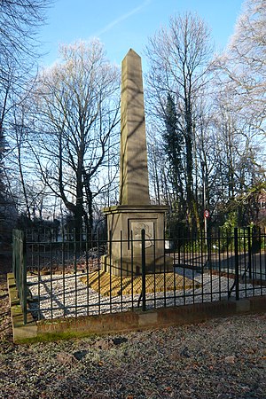
De Naald (the Needle) is a monument in Heemstede, Netherlands, erected in 1817 by the city council to commemorate two battles on the Manpad road running next to the site. The site is at the corner of the Manpad, and Herenweg, on property belonging to the estate 'Huis te Manpad'.

Museum De Cruquius
Museum in Cruquius, the Netherlands
Distance: Approx. 497 meters
Latitude and longitude: 52.33805556,4.63833333
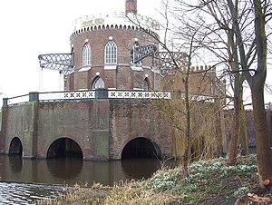
The Museum De Cruquius (or Cruquiusmuseum) occupies the old Cruquius steam pumping station in Cruquius, the Netherlands. It derives its name from Nicolaas Kruik (1678–1754), a Dutch land-surveyor and one of many promoters of a plan to pump the Haarlemmermeer (Haarlem lake) dry. Like many well-educated men of his time, he latinized his name to Nicolaus Samuel Cruquius.
Huis te Manpad
Distance: Approx. 2088 meters
Latitude and longitude: 52.33555556,4.60055556
The Huis te Manpad is an historical villa and former summer home of Jacob van Lennep in Heemstede, the Netherlands; bordered by the Leidsevaart canal, the Manpadslaan, and the Herenweg. It neighbors the estate of Hartekamp, famed for the gardens described by Carl Linnaeus. Both estates still have trees and other flora dating from that period.
Iepenrode
Villa in the Netherlands
Distance: Approx. 2022 meters
Latitude and longitude: 52.3475,4.60638889
Iepenrode, or Ipenrode, is the name of a villa in Heemstede, the Netherlands, between the Leidsevaart and Herenweg, located north of Huis te Manpad and south of Berkenrode. It was once the summer home of various mayors (burgemeesters) of Haarlem and is currently privately owned.

De Eenhoorn, Haarlem
Distance: Approx. 2387 meters
Latitude and longitude: 52.358432,4.637938
De Eenhoorn (Dutch pronunciation: [də ˈʔeːnɦoːr(ə)n]; English: The Unicorn) is a paltrok mill in Haarlem, Netherlands which has been restored to working order. As all Dutch paltrok mills it is a windpowered sawmill. The mill is listed as a Rijksmonument, number 19872.

Floriade 2002
Distance: Approx. 2482 meters
Latitude and longitude: 52.3358,4.6675
The 2002 Floriade international horticultural exposition took place from April 6 to October 20, 2002, in Haarlemmermeer, Netherlands, with a theme of Contribution of Horticulture in the quality of life in the 21st century. Recognised by the Bureau International des Expositions (BIE), the festival covered 65 hectares and had 30 participating countries. Across the Floriade site is the Geniedijk, part of the Defence Line of Amsterdam, while the "Lake Side" was located in the Haarlemmermeer Woods.
Weather in this IP's area
light intensity drizzle
7 Celsius
6 Celsius
7 Celsius
8 Celsius
1025 hPa
96 %
1025 hPa
1025 hPa
2000 meters
1.79 m/s
2.68 m/s
136 degree
75 %
07:52:24
16:58:20

