Country:
 Netherlands
Region:
City:
Latitude and Longitude:
Time Zone:
Postal Code:
IP information under different IP Channel
ip-api
Country
Region
City
ASN
Time Zone
ISP
Blacklist
Proxy
Latitude
Longitude
Postal
Route
IPinfo
Country
Region
City
ASN
Time Zone
ISP
Blacklist
Proxy
Latitude
Longitude
Postal
Route
MaxMind
Country
Region
City
ASN
Time Zone
ISP
Blacklist
Proxy
Latitude
Longitude
Postal
Route
Luminati
Country
NLRegion
nb
City
geertruidenberg
ASN
Time Zone
Europe/Amsterdam
ISP
Vodafone Libertel B.V.
Latitude
Longitude
Postal
db-ip
Country
Region
City
ASN
Time Zone
ISP
Blacklist
Proxy
Latitude
Longitude
Postal
Route
ipdata
Country
Region
City
ASN
Time Zone
ISP
Blacklist
Proxy
Latitude
Longitude
Postal
Route
Popular places and events near this IP address

Bergen op Zoom
City and municipality in North Brabant, Netherlands
Distance: Approx. 7761 meters
Latitude and longitude: 51.5,4.3
Bergen op Zoom (Dutch pronunciation: [ˌbɛrɣə(n) ɔp ˈsoːm] ; called Berrege [ˈbɛrəɣə] in the local dialect) is a city and municipality in southwestern Netherlands. It is located in the province of North Brabant, at the provincial border with Zeeland. In January 2021, the municipality had a population of 67,514.

Woensdrecht
Municipality in North Brabant, Netherlands
Distance: Approx. 1801 meters
Latitude and longitude: 51.41666667,4.33333333
Woensdrecht (Dutch pronunciation: [ˈʋunzdrɛxt] ) is a municipality (named after the village) in the southern Netherlands. Woensdrecht is the home of the Woensdrecht Air Base, which is located to the north-east of the village of Woensdrecht and to the north-west of Huijbergen.

Scheldt–Rhine Canal
Canal connecting Belgium and Netherlands
Distance: Approx. 7023 meters
Latitude and longitude: 51.452,4.23
The Scheldt–Rhine Canal (Schelde-Rijnkanaal) in Belgium and the Netherlands connects Antwerp with the Volkerak, and thereby the Scheldt with the Rhine.

Verdronken Land van Reimerswaal
Area of flood-covered land in Zeeland, Netherlands
Distance: Approx. 6820 meters
Latitude and longitude: 51.4487,4.23145
Het Verdronken Land van Reimerswaal (translation: The Drowned Land of Reimerswaal) is an area of flood-covered land in Zeeland in the Netherlands between Noord Beveland and Bergen op Zoom. Some of it was lost in the St. Felix's Flood in 1530, and some of it in 1532.

Siege of Bergen op Zoom (1622)
Battle between Dutch and Spanish in 1622
Distance: Approx. 7761 meters
Latitude and longitude: 51.5,4.3
The Siege of Bergen op Zoom (1622) was a siege during the Eighty Years' War that took place from 18 July to 2 October 1622. The Spanish general Ambrosio Spinola laid siege to the Dutch city of Bergen op Zoom.

Huijbergen
Village in North Brabant, Netherlands
Distance: Approx. 3304 meters
Latitude and longitude: 51.41666667,4.36666667
Huijbergen is a village in the Dutch province of North Brabant. It is located in the municipality of Woensdrecht, about 9 kilometres (5.6 mi) southeast of Bergen op Zoom, close to the Belgian border.
Ossendrecht
Village in North Brabant, Netherlands
Distance: Approx. 4266 meters
Latitude and longitude: 51.39388889,4.32777778
Ossendrecht is a village in the Dutch province of North Brabant. It is located in the municipality of Woensdrecht, about 12 km southeast of Bergen op Zoom. The village was first mentioned in 1187 as "Alardus de Ossendreht", and is a combination of ferry / waterway and ox.
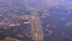
Woensdrecht Air Base
Airport in Woensdrecht
Distance: Approx. 2149 meters
Latitude and longitude: 51.44888889,4.34166667
Woensdrecht Air Base (Dutch: Vliegbasis Woensdrecht) (IATA: WOE, ICAO: EHWO) is a military airport between the villages of Woensdrecht and Huijbergen, about 10 kilometres (6.2 mi) south of the city of Bergen op Zoom in the Netherlands. It is located near the A58 motorway and the border with Belgium. The airport was founded in 1934 as a glider and training airfield for the Royal Netherlands Air Force.

Gertrudiskerk
Church in Bergen op Zoom, the Netherlands
Distance: Approx. 7414 meters
Latitude and longitude: 51.49444444,4.28805556
The Gertrudiskerk is a church approachable from the large market in the center of Bergen op Zoom, Netherlands. The towers of the church are called "pepper plant towers". An old legend says Saint Gertrude of Nivelles, abbess of the abbey in Nivelles, founded the church in 654.

Bergen op Zoom railway station
Railway station in the Netherlands
Distance: Approx. 7264 meters
Latitude and longitude: 51.49472222,4.29611111
Bergen op Zoom is a railway station located in Bergen op Zoom, Netherlands. The station was opened on 23 December 1863 and is located on the Roosendaal–Vlissingen railway. The services are operated by Nederlandse Spoorwegen.

Woensdrecht (village)
Village in North Brabant, Netherlands
Distance: Approx. 1894 meters
Latitude and longitude: 51.42944444,4.29916667
Woensdrecht is a village in the municipality of Woensdrecht, North Brabant, Netherlands. Woensdrecht is known for Woensdrecht Air Base, a military air base.
Kreekrakdam
Dam in the Netherlands
Distance: Approx. 5480 meters
Latitude and longitude: 51.43,4.24722222
The Kreekrakdam is a 3.5 km long dam, that was constructed from 1861 to 1867 as a necessary part of the Roosendaal–Vlissingen railway, the so-called Zeeuwse Lijn (Zealandic Line). Additionally this dam connected the island of Zuid-Beveland with the mainland of Brabant across the Kreekrak waterway.
Weather in this IP's area
overcast clouds
23 Celsius
23 Celsius
22 Celsius
23 Celsius
1021 hPa
56 %
1021 hPa
1020 hPa
10000 meters
6.17 m/s
50 degree
100 %
07:24:30
19:48:24