Country:
Region:
City:
Latitude and Longitude:
Time Zone:
Postal Code:
IP information under different IP Channel
ip-api
Country
Region
City
ASN
Time Zone
ISP
Blacklist
Proxy
Latitude
Longitude
Postal
Route
Luminati
Country
Region
nb
City
bergenopzoom
ASN
Time Zone
Europe/Amsterdam
ISP
Vodafone Libertel B.V.
Latitude
Longitude
Postal
IPinfo
Country
Region
City
ASN
Time Zone
ISP
Blacklist
Proxy
Latitude
Longitude
Postal
Route
db-ip
Country
Region
City
ASN
Time Zone
ISP
Blacklist
Proxy
Latitude
Longitude
Postal
Route
ipdata
Country
Region
City
ASN
Time Zone
ISP
Blacklist
Proxy
Latitude
Longitude
Postal
Route
Popular places and events near this IP address

Bergen op Zoom
City and municipality in North Brabant, Netherlands
Distance: Approx. 1008 meters
Latitude and longitude: 51.5,4.3
Bergen op Zoom (Dutch pronunciation: [ˌbɛrɣə(n) ɔp ˈsoːm] ; called Berrege [ˈbɛrəɣə] in the local dialect) is a city and municipality in southwestern Netherlands. It is located in the province of North Brabant, at the provincial border with Zeeland. In January 2021, the municipality had a population of 67,514.

Siege of Bergen op Zoom (1622)
Battle between Dutch and Spanish in 1622
Distance: Approx. 1008 meters
Latitude and longitude: 51.5,4.3
The siege of Bergen op Zoom (1622) was a siege during the Eighty Years' War that took place from 18 July to 2 October 1622. The Spanish general Ambrosio Spinola laid siege to the Dutch city of Bergen op Zoom.
Halsteren
Town in North Brabant, Netherlands
Distance: Approx. 3922 meters
Latitude and longitude: 51.51666667,4.26666667
Halsteren is a town in the Dutch province of North Brabant. It is located in the municipality of Bergen op Zoom, about 1 km north of that city. Halsteren has an old church from the 14th century and a new church, built in 1919.

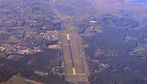
Woensdrecht Air Base
Airport in Woensdrecht
Distance: Approx. 5375 meters
Latitude and longitude: 51.44888889,4.34166667
Woensdrecht Air Base (Dutch: Vliegbasis Woensdrecht) (IATA: WOE, ICAO: EHWO) is a military airport between the villages of Woensdrecht and Huijbergen, about 10 kilometres (6.2 mi) south of the city of Bergen op Zoom in the Netherlands. It is located near the A58 motorway and the border with Belgium. The airport was founded in 1934 as a glider and training airfield for the Royal Netherlands Air Force.

Heerle
Village in North Brabant, Netherlands
Distance: Approx. 4618 meters
Latitude and longitude: 51.51833333,4.35916667
Heerle (Brabantic: Èrel) is a village in the municipality of Roosendaal, in the Dutch province of North Brabant. Before the municipal reorganisation of 1997, Heerle was part of the municipality of Wouw. It lies between the cities of Bergen op Zoom and Roosendaal.

Gertrudiskerk
Church in Bergen op Zoom, the Netherlands
Distance: Approx. 1364 meters
Latitude and longitude: 51.49444444,4.28805556
The Gertrudiskerk is a church approachable from the large market in the center of Bergen op Zoom, Netherlands. The towers of the church are called "pepper plant towers". An old legend says Saint Gertrude of Nivelles, abbess of the abbey in Nivelles, founded the church in 654.

Bergen op Zoom railway station
Railway station in the Netherlands
Distance: Approx. 831 meters
Latitude and longitude: 51.49472222,4.29611111
Bergen op Zoom is a railway station located in Bergen op Zoom, Netherlands. The station was opened on 23 December 1863 and is located on the Roosendaal–Vlissingen railway. The services are operated by Nederlandse Spoorwegen.

Fort de Roovere
Fort in The Netherlands
Distance: Approx. 4107 meters
Latitude and longitude: 51.52888889,4.30111111
Fort De Roovere is an earthen fort, constructed as part of the Dutch Water Line, (Hollandse Waterlinie), a series of water-based defences conceived by Maurice of Nassau in 1628 during the Eighty Years War where it defended against Spanish attackers. It is located near Halsteren. In 1747, during the Austrian War of Succession (1740–1748) the fort was under siege by the French.

De Arend, Wouw
Windmill in North Brabant, Netherlands
Distance: Approx. 6031 meters
Latitude and longitude: 51.516389,4.385278
De Arend (English: The Eagle) is a windmill located on the Akkerstraat 11 in Wouw, Roosendaal, in the province of North Brabant, Netherlands. Built in 1811 on an artificial hill, the windmill functioned as a gristmill. The mill was built as a tower mill and its sails have a span of 25.85 metres (84.8 ft).

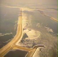
Oesterdam
Compartmentalisation dam in the Netherlands, part of the Delta Works
Distance: Approx. 6249 meters
Latitude and longitude: 51.47872222,4.21988889
The Oesterdam (English: Oyster Dam) is a compartmentalisation dam in The Netherlands, situated between Tholen and South Beveland in the eastern part of the Eastern Scheldt. The dam, with a length of 10.5 kilometres, is the longest structure built for the Delta Works. The Oesterdam was necessitated, like the Philipsdam, after the decision was taken to close off the Eastern Scheldt with a storm surge barrier, rather than a solid dam.

Markiezaatskade
Dam in the Netherlands
Distance: Approx. 5808 meters
Latitude and longitude: 51.47205556,4.23011111
The Markiezaatskade is a compartmentalisation dam in The Netherlands, situated between South Beveland and Molenplaat, near Bergen op Zoom. The dam was constructed as part of the Delta Works, and has a length of 4 kilometres (2.5 miles). The dam was conceived as an auxiliary dam to permit the construction of the Oesterdam, and encloses the Markiezaat area of Bergen op Zoom.

St Mary's Church, Rotterdam
Distance: Approx. 6034 meters
Latitude and longitude: 51.542,4.273
St Mary's Church or the English Church (Dutch: Engelse Kerk) is an Anglican church in Rotterdam in the Netherlands. It is part of the Archdeaconry of North West Europe in the Diocese in Europe of the Church of England.
Weather in this IP's area
mist
8 Celsius
8 Celsius
7 Celsius
9 Celsius
1025 hPa
100 %
1025 hPa
1024 hPa
4900 meters
1.03 m/s
100 %
07:50:54
17:02:26
