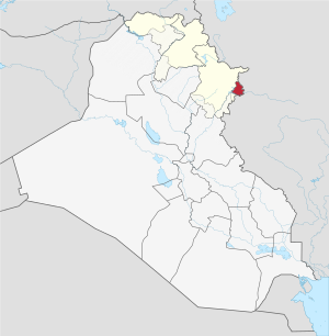
212.126.96.200 - IP Lookup: Free IP Address Lookup, Postal Code Lookup, IP Location Lookup, IP ASN, Public IP
Country:
Region:
City:
Location:
Time Zone:
Postal Code:
IP information under different IP Channel
ip-api
Country
Region
City
ASN
Time Zone
ISP
Blacklist
Proxy
Latitude
Longitude
Postal
Route
Luminati
Country
ASN
Time Zone
Asia/Baghdad
ISP
AL-SARD FIBER Co. for Internet Fiber and Optical Cable Services /Ltd.
Latitude
Longitude
Postal
IPinfo
Country
Region
City
ASN
Time Zone
ISP
Blacklist
Proxy
Latitude
Longitude
Postal
Route
IP2Location
212.126.96.200Country
Region
as sulaymaniyah
City
halabjah
Time Zone
Asia/Baghdad
ISP
Language
User-Agent
Latitude
Longitude
Postal
db-ip
Country
Region
City
ASN
Time Zone
ISP
Blacklist
Proxy
Latitude
Longitude
Postal
Route
ipdata
Country
Region
City
ASN
Time Zone
ISP
Blacklist
Proxy
Latitude
Longitude
Postal
Route
Popular places and events near this IP address

Halabja
City in Kurdistan Region, Iraq
Distance: Approx. 665 meters
Latitude and longitude: 35.18333333,45.98333333
Halabja (Kurdish: هەڵەبجە, romanized: Helebce, Arabic: حلبجة) is a city in the Kurdistan Region of Iraq and the capital of Halabja Governorate, located about 240 km (150 mi) northeast of Baghdad and 14 km (9 mi) from the Iranian border. The city lies at the base of what is often referred to as the greater Hewraman region stretching across the Iran–Iraq border. Halabja is surrounded by Hawraman and Shnrwe range in the northeast, Balambo range in the south and Sirwan river in the west.

Operation Viking Hammer
Military operation during the Iraq War
Distance: Approx. 663 meters
Latitude and longitude: 35.1833,45.9833
Operation Viking Hammer was an unconventional warfare operation during the Iraq War which took place in northern Iraq, commonly known as Iraqi Kurdistan. The goal of the operation was to eliminate Ansar al-Islam and dismantle the Islamic Emirate of Byara. Ansar al-Islam was established by former Al-Qaeda members in 2001 as a Kurdish Salafist movement that imposed a strict application of Sharia in villages it controlled.

Halabja Governorate
Governorate of the Kurdistan Region, Iraq.
Distance: Approx. 2776 meters
Latitude and longitude: 35.2,46
Halabja Governorate (Kurdish: پارێزگای ھەڵەبجە, romanized: Parêzgay Helebceyê, Arabic: محافظة حلبجة, romanized: Muḥāfaẓat Ḥalabja) is a governorate in the semi-autonomous region of Kurdistan Region in Iraq. The governorate was established in 2014, splitting off from Sulaymaniyah Governorate and becoming the fourth governorate in the Kurdistan Region of Iraq. Its capital is the city of Halabja.

University of Halabja
Public university in Iraqi Kurdistan
Distance: Approx. 3393 meters
Latitude and longitude: 35.1729,46.0229
The University of Halabja, orUoH (زانكۆى ههڵهبجه in Kurdish) is one of the Iraqi Kurdistan public universities founded in 2011 in the city of Halabja, Halabja Governorate. The university offers a variety of programs such as human sciences, law, physical education, engineering, sciences. Programs last for four years and students receive BA degrees in their corresponding fields at the end of the fourth year.
Bakr Awa
Distance: Approx. 6310 meters
Latitude and longitude: 35.22055611,45.94055611
Bakr Awa is a tell, or archaeological settlement mound, in Sulaymaniyah Province, Iraq. It is located near Halabja in the Shahrizor Plain in Iraqi Kurdistan. It is in the foothills of the Zagros Mountains not far from the headwaters of the Diyala River.

Halabja Stadium
Stadium in Iraq
Distance: Approx. 3648 meters
Latitude and longitude: 35.20361111,45.96138889
Halabja Stadium (Kurdish: یاریگای ھەڵەبجە, Arabic: ملعب حلبجة) is a multi-purpose stadium in Halabja, Northern Iraq. It is currently used mostly for football matches and serves as the home stadium of Halabja SC. The stadium holds 9,000 people.
Weather in this IP's area
clear sky
12 Celsius
10 Celsius
12 Celsius
12 Celsius
1023 hPa
39 %
1023 hPa
922 hPa
10000 meters
0.91 m/s
1.46 m/s
54 degree