212.122.178.63 - IP Lookup: Free IP Address Lookup, Postal Code Lookup, IP Location Lookup, IP ASN, Public IP
Country:
Region:
City:
Location:
Time Zone:
Postal Code:
IP information under different IP Channel
ip-api
Country
Region
City
ASN
Time Zone
ISP
Blacklist
Proxy
Latitude
Longitude
Postal
Route
Luminati
Country
Region
22
City
sofia
ASN
Time Zone
Europe/Sofia
ISP
Council of Ministers
Latitude
Longitude
Postal
IPinfo
Country
Region
City
ASN
Time Zone
ISP
Blacklist
Proxy
Latitude
Longitude
Postal
Route
IP2Location
212.122.178.63Country
Region
sofia (stolitsa)
City
sofia
Time Zone
Europe/Sofia
ISP
Language
User-Agent
Latitude
Longitude
Postal
db-ip
Country
Region
City
ASN
Time Zone
ISP
Blacklist
Proxy
Latitude
Longitude
Postal
Route
ipdata
Country
Region
City
ASN
Time Zone
ISP
Blacklist
Proxy
Latitude
Longitude
Postal
Route
Popular places and events near this IP address
Bulgarian National Bank
Central bank of Bulgaria
Distance: Approx. 152 meters
Latitude and longitude: 42.69638889,23.32527778
The Bulgarian National Bank (Bulgarian: Българска народна банка, romanized: Bulgarska narodna banka, IPA: [ˈbɤɫɡɐrskɐ nɐˈrɔdnɐ ˈbaŋkɐ], BNB) is the central bank of the Republic of Bulgaria. It has also been Bulgaria's national competent authority within European Banking Supervision since 2020. Headquartered in Sofia, the bank was established in 1879.
Church of Saint George, Sofia
Red brick rotunda in Sofia, Bulgaria
Distance: Approx. 129 meters
Latitude and longitude: 42.696875,23.322875
The Church of Saint George (Bulgarian: Ротонда „Свети Георги“, romanized: Rotonda "Sveti Georgi") is a Late Antique red brick rotunda in Sofia, Bulgaria. Built in the early 4th century as Roman baths, it became a church inside the walls of Serdica, capital of ancient Dacia Mediterranea during the Roman Empire and Byzantine Empire. The Early Christian church is considered the oldest building in modern Sofia and belongs to the Bulgarian Orthodox Church.
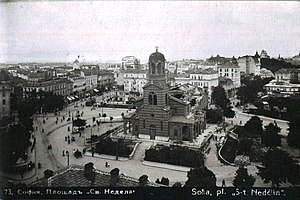
St. Nedelya Church assault
1925 bombing of a church in Sofia, Bulgaria by Communist Party militants
Distance: Approx. 235 meters
Latitude and longitude: 42.6966,23.3216
The St Nedelya Church assault was a terrorist attack on St Nedelya Church in Sofia, Bulgaria. It was carried out on 16 April 1925, when a group of the Military Organisation of the Bulgarian Communist Party directed and supplied by the Soviet Military Intelligence blew up the church's roof during the funeral service of General Konstantin Georgiev, who had been killed in a previous communist assault on 14 April. Over 200 people, mainly from the country's political and military elite, were killed in the attack and around 500 bystander worshipers, who attended the liturgy, were injured.
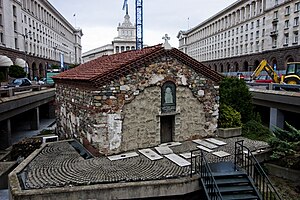
Church of St Petka of the Saddlers
Bulgarian Orthodox church in Sofia, Bulgaria
Distance: Approx. 173 meters
Latitude and longitude: 42.69783333,23.32213889
The Church of St Petka of the Saddlers (Bulgarian: Църква „Света Петка Самарджийска“) is a medieval Bulgarian Orthodox church in Sofia, the capital of Bulgaria. It is a small one-naved building partially dug into the ground located in the very centre of both the modern and the antique city, in the TZUM underpass. The church features a semi-cylindrical vault, a hemispherical apse, and a crypt discovered during excavations after the Second World War.

National Archaeological Museum, Bulgaria
Archaeological museum and research institute in Sofia, Bulgaria
Distance: Approx. 134 meters
Latitude and longitude: 42.69633056,23.32456389
The National Archaeological Museum (Bulgarian: Национален археологически музей, Natsionalen arheologicheski muzey) is an archaeological museum in the centre of Sofia, the capital of Bulgaria. It occupies the building of the largest and oldest former Ottoman mosque in the city, originally known as Koca Mahmut Paşa Camii. The construction started in 1451 under grand vizier Veli Mahmud Pasha but due to his death in 1474 the mosque has been completed in 1494.

Sofia Central Mineral Baths
Thermal springs and a building housing them
Distance: Approx. 187 meters
Latitude and longitude: 42.69916667,23.32388889
The Central Mineral Baths (Централна минерална баня, Tsentralna mineralna banya) is a landmark in the city center of Sofia, the capital of Bulgaria, a city known for the mineral springs in the area. It was built in the early 20th century near the former Turkish bath (then destroyed) and was used as the city's public baths until 1986.
Largo, Sofia
Distance: Approx. 99 meters
Latitude and longitude: 42.69777778,23.32305556
The Largo (Bulgarian: Ларго, definite form Ларгото, Largoto) is an architectural ensemble of three Socialist Classicism edifices in central Sofia, the capital of Bulgaria, designed and built in the 1950s with the intention of becoming the city's new representative centre. Today it is regarded as one of the prime examples of Socialist Classicism architecture in Southeastern Europe, as well as one of the main landmarks of Sofia. The yellow-cobblestoned square around which the ensemble is centred is called Nezavisimost (Independence) Square.
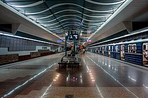
Serdika Metro Station
Sоfia metro station
Distance: Approx. 232 meters
Latitude and longitude: 42.69777778,23.32138889
Serdika Metro Station (Bulgarian: Метростанция „Сердика“) is an M1 and M4 lines station of Sofia Metro. It was put into operation on 31 October 2000. With the opening of Serdika II on 31 August 2012 the station became an interchange between the Red and Blue lines.
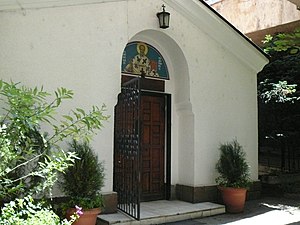
Church of St. Nicholas, Sofia
Distance: Approx. 204 meters
Latitude and longitude: 42.69596,23.32284
The Church of St. Nicholas (Bulgarian: Свети Николай Мирликийски чудотворец) is an Eastern Orthodox Church in the Bulgarian capital of Sofia. The church was built in the 13th century by Kaloyan the sebastocrator as a small family church on today's Kaloyan Street behind the Rila Hotel.

Serdika II Metro Station
Sоfia metro station
Distance: Approx. 223 meters
Latitude and longitude: 42.69871111,23.32203056
Serdika II Metro Station (Bulgarian: Метростанция „Сердика II“) is an M2 line station of Sofia Metro. It was put into operation on August 31, 2012 and the station became transfer station between the Red and Blue lines together with Serdika, however it is not a true transfer station (that role is filled by Obelya), but a tunnel-connection transfer station. Bulgaria's PM Boyko Borisov and the President of the European Commission Jose Manuel Barroso inaugurated the new section of the Sofia Metro, which was funded with EU money.
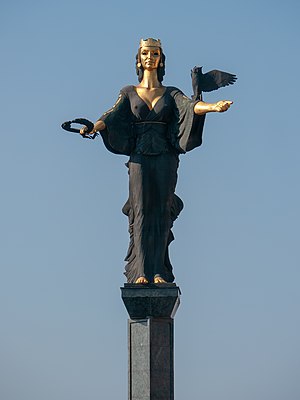
Statue of Sveta Sofia
Historic site in Sofia, Bulgaria
Distance: Approx. 226 meters
Latitude and longitude: 42.69778983,23.321469
The Statue of Sofia (Bulgarian: Статуя на София, romanized: Statuya na Sofiya) is a monumental sculpture in Sofia, Bulgaria. It was officially opened to the public by the capital's mayor Stefan Sofiyanski on December 28, 2000. The Statue of Sofia was approved by the Sofia City Council on September 17, 2000, known as the Day of Sofia in Bulgaria.
Stolichna Municipality
Municipality of Bulgaria
Distance: Approx. 50 meters
Latitude and longitude: 42.6976,23.3236
The Stolichna Municipality (Bulgarian: Столична община, romanized: Stolichna obshtina (also transcribed as Stolična obština), lit. 'Capital Municipality') is an obshtina (municipality) in Sofia City Province, Western Bulgaria. It is named after its administrative centre, the city of Sofia, which is also the capital of Sofia City Province and Sofia Province and the capital of Bulgaria as well. The municipality is located mainly in the Sofia Valley, and also in the foots and lower parts of the mountains of Stara planina and Vitosha, Plana, Lozen, Rila.
Weather in this IP's area
snow
-0 Celsius
-6 Celsius
-0 Celsius
1 Celsius
1021 hPa
92 %
1021 hPa
953 hPa
1800 meters
7.2 m/s
270 degree
100 %


