Country:
Region:
City:
Latitude and Longitude:
Time Zone:
Postal Code:
IP information under different IP Channel
ip-api
Country
Region
City
ASN
Time Zone
ISP
Blacklist
Proxy
Latitude
Longitude
Postal
Route
Luminati
Country
Region
an
City
alhamadealmeria
ASN
Time Zone
Europe/Madrid
ISP
XFERA Moviles S.A.
Latitude
Longitude
Postal
IPinfo
Country
Region
City
ASN
Time Zone
ISP
Blacklist
Proxy
Latitude
Longitude
Postal
Route
db-ip
Country
Region
City
ASN
Time Zone
ISP
Blacklist
Proxy
Latitude
Longitude
Postal
Route
ipdata
Country
Region
City
ASN
Time Zone
ISP
Blacklist
Proxy
Latitude
Longitude
Postal
Route
Popular places and events near this IP address

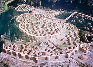
Los Millares
Chalcolithic occupation site in Spain
Distance: Approx. 4390 meters
Latitude and longitude: 36.96472222,-2.52222222
Los Millares is a Chalcolithic occupation site 17 km north of Almería, in the municipality of Santa Fe de Mondújar, Andalucía, Spain. The complex was in use from the fourth millennium BC (c. 3000 BC) to the end of the third millennium BC (2000 BC) and probably supported somewhere around 1000 people. It was discovered in 1891 during the construction of a railway.

Alhabia
Place in Andalusia, Spain
Distance: Approx. 3610 meters
Latitude and longitude: 36.98333333,-2.58333333
Alhabia is a municipality of Almería province, in Spain.

Alicún
Place in Andalusia, Spain
Distance: Approx. 3131 meters
Latitude and longitude: 36.96666667,-2.6
Alicún is a municipality of Almería province, in the autonomous community of Andalusia, Spain.

Alsodux
Place in Andalusia, Spain
Distance: Approx. 5390 meters
Latitude and longitude: 37,-2.58333333
Alsodux is a municipality of Almería province, in the autonomous community of Andalusia, Spain.

Bentarique
Place in Andalusia, Spain
Distance: Approx. 5406 meters
Latitude and longitude: 36.98333333,-2.61666667
Bentarique is a municipality of Almería province, in the autonomous community of Andalusia, Spain.

Gádor
Place in Andalusia, Spain
Distance: Approx. 7654 meters
Latitude and longitude: 36.95,-2.48333333
Gádor is a municipality of Almería province, in the autonomous community of Andalusia, Spain. The murder of Bernardo Gonzalez Parra by Francisco Leona happened on 28 June 1910 in Gádor.
Huécija
Place in Andalusia, Spain
Distance: Approx. 3131 meters
Latitude and longitude: 36.96666667,-2.6
Huécija is a municipality of Almería province, in the autonomous community of Andalusia, Spain. It has two churches, one of which the Convento de los Agustinos, is notable as an example of baroque architecture.
Íllar
Place in Andalusia, Spain
Distance: Approx. 6627 meters
Latitude and longitude: 36.98333333,-2.63333333
Illar is a municipality in the Almería province, an autonomous community of Andalusia, Spain.

Santa Fe de Mondújar
Place in Andalusia, Spain
Distance: Approx. 4926 meters
Latitude and longitude: 36.96666667,-2.51666667
Santa Fe de Mondújar is a municipality of the Province of Almería, in the autonomous community of Andalusia, Spain.

Terque
Place in Andalusia, Spain
Distance: Approx. 3610 meters
Latitude and longitude: 36.98333333,-2.58333333
Terque is a municipality of Almería province, in the autonomous community of Andalusia, Spain.

Alpujarra Almeriense
Comarca in Andalusia, Spain
Distance: Approx. 399 meters
Latitude and longitude: 36.95,-2.56666667
Alpujarra Almeriense is a Spanish comarca in the Province of Almería, Andalusia. Along with Alpujarra Granadina, is part of the Andalusian region of the Alpujarras.

Convento de los Agustinos
Buildings in Andalusia, Spain
Distance: Approx. 3882 meters
Latitude and longitude: 36.96805556,-2.60861111
The Augustinian convent (Spanish: Convento de los Agustinos) is one of the most important landmarks of Huécija municipality in the province of Almería in Andalusia, Spain. It consists of a baroque church and some remains of the Augustinian monastery which it formerly served.
Weather in this IP's area
overcast clouds
16 Celsius
16 Celsius
16 Celsius
16 Celsius
1019 hPa
68 %
1019 hPa
960 hPa
10000 meters
4.43 m/s
6.96 m/s
40 degree
87 %
07:49:10
18:00:56

