Country:
 Netherlands
Region:
City:
Latitude and Longitude:
Time Zone:
Postal Code:
IP information under different IP Channel
ip-api
Country
Region
City
ASN
Time Zone
ISP
Blacklist
Proxy
Latitude
Longitude
Postal
Route
IPinfo
Country
Region
City
ASN
Time Zone
ISP
Blacklist
Proxy
Latitude
Longitude
Postal
Route
MaxMind
Country
Region
City
ASN
Time Zone
ISP
Blacklist
Proxy
Latitude
Longitude
Postal
Route
Luminati
Country
NLRegion
ze
City
renesse
ASN
Time Zone
Europe/Amsterdam
ISP
DELTA Fiber Nederland B.V.
Latitude
Longitude
Postal
db-ip
Country
Region
City
ASN
Time Zone
ISP
Blacklist
Proxy
Latitude
Longitude
Postal
Route
ipdata
Country
Region
City
ASN
Time Zone
ISP
Blacklist
Proxy
Latitude
Longitude
Postal
Route
Popular places and events near this IP address
Ellemeet
Village in Zeeland, Netherlands
Distance: Approx. 3669 meters
Latitude and longitude: 51.72972222,3.81638889
Ellemeet is a village in the Dutch province of Zeeland. It is a part of the municipality of Schouwen-Duiveland, and lies about 26 km west of Hellevoetsluis.

Haamstede
Village in Zeeland, Netherlands
Distance: Approx. 4012 meters
Latitude and longitude: 51.69666667,3.74361111
Haamstede is a village in the Dutch province of Zeeland. It is a part of the municipality of Schouwen-Duiveland. The village is known for Haamstede Castle.

Burgh, Netherlands
Village in Zeeland, Netherlands
Distance: Approx. 5231 meters
Latitude and longitude: 51.68861111,3.72916667
Burgh is a village in the Dutch province of Zeeland. It is connected to Haamstede, and therefore generally considered to be part of the village Burgh-Haamstede.
Nieuw-Haamstede
Hamlet in Zeeland, Netherlands
Distance: Approx. 4633 meters
Latitude and longitude: 51.7114,3.7036
Nieuw-Haamstede is a hamlet in the Dutch province of Zeeland. It is a part of the municipality of Schouwen-Duiveland, and lies about 25 km north of Middelburg. It was built before 1940 as a holiday neighbourhood in the dunes belonging to Haamstede.
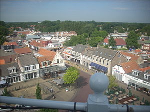
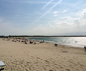
Renesse
Village in Zeeland, Netherlands
Distance: Approx. 703 meters
Latitude and longitude: 51.73222222,3.77305556
Renesse (Zeeuws: Renisse) is a village in the Dutch province of Zeeland. It is a part of the municipality of Schouwen-Duiveland, and lies about 28 km west of Hellevoetsluis. Renesse is a popular tourist resort with zero-fare bus services in the area (in summer only).

Noordwelle
Village in Zeeland, Netherlands
Distance: Approx. 2470 meters
Latitude and longitude: 51.71833333,3.79305556
Noordwelle is a village in the Dutch province of Zeeland. It is a part of the municipality of Schouwen-Duiveland, and lies about 5 km southwest of Scharendijke. The village was first mentioned in 1109 as Willa, and means well.

Serooskerke, Schouwen-Duiveland
Village in Zeeland, Netherlands
Distance: Approx. 4838 meters
Latitude and longitude: 51.70111111,3.81472222
Serooskerke is a village in the southwest Netherlands. It is located in the municipality of Schouwen-Duiveland, Zeeland about 100 km southwest of Rotterdam.
Burghsluis
Hamlet in Zeeland, Netherlands
Distance: Approx. 5340 meters
Latitude and longitude: 51.68333333,3.75
Burghsluis is a hamlet in the Dutch province of Zeeland. It is a part of the municipality of Schouwen-Duiveland, and lies about 22 km north of Middelburg. Burghsluis is not a statistical entity, and the postal authorities have placed it under Burgh-Haamstede.
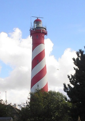
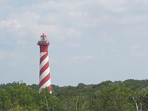
Westerlichttoren
Lighthouse
Distance: Approx. 5496 meters
Latitude and longitude: 51.70897222,3.69155556
The Westerlichttoren or West Schouwen is a lighthouse in Haamstede, Netherlands. Designed by L. Valk, it was built in 1837. At 47 m (154 ft) above ground and a light stand at 58 m (190 ft) above sea level it is one of the tallest lighthouses in the Netherlands.

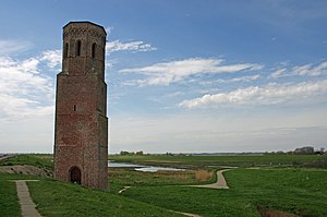
Haamstede Castle
Castle in the village of Haamstede on the island of Schouwen-Duiveland
Distance: Approx. 3917 meters
Latitude and longitude: 51.697914,3.742163
Haamstede Castle (Dutch: Slot Haamstede) is a castle in the village of Haamstede on the island of Schouwen-Duiveland. It is a rijksmonument.
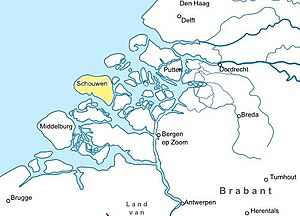
Schouwen
Distance: Approx. 2470 meters
Latitude and longitude: 51.71833333,3.79305556
Schouwen is the name of a former island of the Dutch province of Zeeland. The island of Schouwen was joined to Duiveland in 1610, forming the island of Schouwen-Duiveland. It is the western part of the current island.

Moermond Castle
Distance: Approx. 1640 meters
Latitude and longitude: 51.733687,3.786454
Moermond Castle is a castle in Renesse on Schouwen-Duiveland.
Weather in this IP's area
overcast clouds
20 Celsius
20 Celsius
20 Celsius
22 Celsius
1007 hPa
73 %
1007 hPa
1007 hPa
10000 meters
7.5 m/s
9.35 m/s
201 degree
86 %
07:09:04
20:16:22