Country:
 Netherlands
Region:
City:
Latitude and Longitude:
Time Zone:
Postal Code:
IP information under different IP Channel
ip-api
Country
Region
City
ASN
Time Zone
ISP
Blacklist
Proxy
Latitude
Longitude
Postal
Route
IPinfo
Country
Region
City
ASN
Time Zone
ISP
Blacklist
Proxy
Latitude
Longitude
Postal
Route
MaxMind
Country
Region
City
ASN
Time Zone
ISP
Blacklist
Proxy
Latitude
Longitude
Postal
Route
Luminati
Country
NLRegion
ze
City
sheerarendskerke
ASN
Time Zone
Europe/Amsterdam
ISP
DELTA Fiber Nederland B.V.
Latitude
Longitude
Postal
db-ip
Country
Region
City
ASN
Time Zone
ISP
Blacklist
Proxy
Latitude
Longitude
Postal
Route
ipdata
Country
Region
City
ASN
Time Zone
ISP
Blacklist
Proxy
Latitude
Longitude
Postal
Route
Popular places and events near this IP address

Goes
City and municipality in Zeeland, Netherlands
Distance: Approx. 4738 meters
Latitude and longitude: 51.5,3.88333333
Goes (Dutch pronunciation: [ɣus] ) is a city and municipality in the southwestern Netherlands on Zuid-Beveland, in the province of Zeeland. The city of Goes has approximately 29,000 residents.

Zuid-Beveland
Peninsula in Zeeland, Netherlands
Distance: Approx. 1226 meters
Latitude and longitude: 51.5,3.8
Zuid-Beveland (Dutch: [ˈzœyd ˌbeːvəlɑnt] ; "South Beveland") is part of the province of Zeeland in the Netherlands north of the Western Scheldt and south of the Eastern Scheldt.
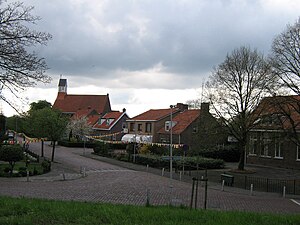
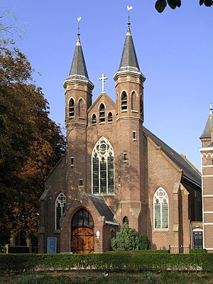
's-Heer Arendskerke
Village in Zeeland, Netherlands
Distance: Approx. 623 meters
Latitude and longitude: 51.49166667,3.82305556
's-Heer Arendskerke is a village in the municipality of Goes in the south-western Netherlands.
Lewedorp
Village in Zeeland, Netherlands
Distance: Approx. 4598 meters
Latitude and longitude: 51.49527778,3.74916667
Lewedorp is a village in the Dutch province of Zeeland. It is a part of the municipality of Borsele, and lies about 9 km east of Middelburg. The village was first mentioned in 1913 as Noordkraaijert.
Heinkenszand
Town in Zeeland, Netherlands
Distance: Approx. 2411 meters
Latitude and longitude: 51.47305556,3.81444444
Heinkenszand is a town in the Dutch province of Zeeland. It is a part of the municipality of Borsele, which has approximately 22,500 inhabitants [1], and lies about 14 km east of Middelburg.

's-Heer Hendrikskinderen
Village in Zeeland, Netherlands
Distance: Approx. 3217 meters
Latitude and longitude: 51.50166667,3.86055556
's-Heer Hendrikskinderen is a village in the municipality of Goes, about 2 km to the west of the city of Goes in the Dutch province of Zeeland.
Sinoutskerke en Baarsdorp
Distance: Approx. 3211 meters
Latitude and longitude: 51.47805556,3.85333333
Sinoutskerke en Baarsdorp is a former municipality in the Dutch province of Zeeland. It existed until 1816, when it was merged with 's-Heer Abtskerke. As its name implies, the municipality It covered two hamlets, Sinoutskerke and Baarsdorp, located west and northwest of 's-Heer Abtskerke.

Wissekerke
Village in Zeeland, Netherlands
Distance: Approx. 2241 meters
Latitude and longitude: 51.50166667,3.84583333
Wissekerke is a hamlet in the Dutch province of Zeeland. It is located in the municipality of Goes. It was first mentioned in 1216 as Wicenkerke, and means "(private) church of Witze (person)".

Wolphaartsdijk
Village in Zeeland, Netherlands
Distance: Approx. 3910 meters
Latitude and longitude: 51.52972222,3.81972222
Wolphaartsdijk is a village in the Netherlands, located in the province Zeeland. Wolphaartsdijk is part of the municipality of Goes. In 2009 the village had 2109 inhabitants.

Relief of Goes
1572 battle of the Eighty Years' War
Distance: Approx. 4738 meters
Latitude and longitude: 51.5,3.88333333
In August 1572, during the course of the Eighty Years' War, the city of Goes, in the Spanish Netherlands, was besieged by Dutch forces with the support of English troops sent by Queen Elizabeth I. This was a menace to the safety of the nearby city of Middelburg, also under siege. Given the impossibility of rescue of Goes by sea, 3,000 soldiers of the Spanish Tercios under the command of Cristóbal de Mondragón waded across the river Scheldt at its mouth, walking 15 miles overnight in water up to chest deep. The surprise arrival of the Tercios forced the withdrawal of the Anglo-Dutch troops from Goes, allowing the Spanish to maintain control of Middelburg, capital of Walcheren Island.

Stoomtrein Goes - Borsele
Distance: Approx. 4541 meters
Latitude and longitude: 51.49777778,3.88083333
The Stoomtrein Goes - Borsele (Goes-Borsele Steam Train) is a heritage railway operating from Goes through Kwadendamme to the village of Hoedekenskerke, in the province of Zeeland, Netherlands.

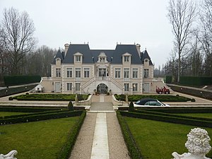
Sabbinge Castle
Castle in the Netherlands
Distance: Approx. 4319 meters
Latitude and longitude: 51.53218,3.799381
Sabbinge Castle is a small castle in Oud-Sabbinge, on the former island Wolphaartsdijk
Weather in this IP's area
broken clouds
20 Celsius
20 Celsius
19 Celsius
21 Celsius
1007 hPa
72 %
1007 hPa
1007 hPa
10000 meters
8.75 m/s
170 degree
75 %
07:09:07
20:15:54