Country:
 Turkey
Region:
City:
Latitude and Longitude:
Time Zone:
Postal Code:
IP information under different IP Channel
ip-api
Country
Region
City
ASN
Time Zone
ISP
Blacklist
Proxy
Latitude
Longitude
Postal
Route
IPinfo
Country
Region
City
ASN
Time Zone
ISP
Blacklist
Proxy
Latitude
Longitude
Postal
Route
MaxMind
Country
Region
City
ASN
Time Zone
ISP
Blacklist
Proxy
Latitude
Longitude
Postal
Route
Luminati
Country
TRRegion
34
City
istanbul
ASN
Time Zone
Europe/Istanbul
ISP
Vodafone Net Iletisim Hizmetler AS
Latitude
Longitude
Postal
db-ip
Country
Region
City
ASN
Time Zone
ISP
Blacklist
Proxy
Latitude
Longitude
Postal
Route
ipdata
Country
Region
City
ASN
Time Zone
ISP
Blacklist
Proxy
Latitude
Longitude
Postal
Route
Popular places and events near this IP address
New Rome
Ancient nickname for the city of Byzantium, later known as Constantinople (modern Istanbul)
Distance: Approx. 201 meters
Latitude and longitude: 41.01388889,28.95555556
New Rome (Greek: Νέα Ῥώμη, Néa Rhṓmē; Koinē Greek: [ˈne̞a ˈr̥o̞ːme̞ː]; Latin: Nova Roma; Late Latin: [ˈnɔwa ˈroma]) was the original name given by the Roman emperor Constantine the Great to his new imperial capital in 330 CE, which was built as an expansion of the city of Byzantium on the European coast of the Bosporus strait. The city was founded as Byzantion (Greek: Βυζάντιον) by Megarian colonists in 657 BCE. It was renamed by Constantine the Great first as "New Rome" (Nova Roma) during the official dedication of the city as the new Roman capital in 330 CE, which he soon afterwards changed to Constantinople (Constantinopolis). The city was officially renamed as Istanbul in the 20th century, after the establishment of the Turkish Republic in 1923.

Istanbul
Largest city in Turkey
Distance: Approx. 174 meters
Latitude and longitude: 41.01361111,28.955
Istanbul is the largest city in Turkey, straddling the Bosporus Strait, the boundary between Europe and Asia. It is considered the country's economic, cultural and historic capital. The city has a population of over 15 million residents, comprising 19% of the population of Turkey, and is the most populous city in Europe and the world's fifteenth-largest city.

Column of Marcian
Monumental column in Istanbul, Turkey
Distance: Approx. 272 meters
Latitude and longitude: 41.01543,28.9503
The Column of Marcian (Greek: Στήλη του Μαρκιανού, Turkish: Kıztaşı) is a Roman honorific column erected in Constantinople by the praefectus urbi Tatianus (450 – c. 452) and dedicated to the Emperor Marcian (450–57). It is located in the present-day Fatih district of Istanbul.
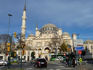
Şehzade Mosque
16th-century Ottoman-era mosque in the capital district of Istanbul
Distance: Approx. 334 meters
Latitude and longitude: 41.01380556,28.95716667
The Şehzade Mosque (Turkish: Şehzade Camii, from the original Persian شاهزاده Šāhzādeh, meaning "prince") is a 16th-century Ottoman imperial mosque located in the district of Fatih, on the third hill of Istanbul, Turkey. It was commissioned by Suleiman the Magnificent as a memorial to his son Şehzade Mehmed who died in 1543. It is sometimes referred to as the "Prince's Mosque" in English.
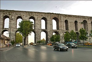
Aqueduct of Valens
Roman aqueduct system located in the Republic of Turkey
Distance: Approx. 248 meters
Latitude and longitude: 41.01594444,28.95555556
The Aqueduct of Valens (Turkish: Valens Su Kemeri, Ancient Greek: Ἀγωγὸς τοῦ ὕδατος, romanized: Agōgós tou hýdatos, lit. 'aqueduct') was a Roman aqueduct system built in the late 4th century AD, to supply Constantinople – the capital of the Eastern Roman Empire. Construction of the aqueduct began during the reign of the Roman emperor Constantius II (r. 337–361) and was completed in 373 by the Emperor Valens (r. 364–378). The aqueduct remained in use for many centuries.

Philadelphion
Public square in Constantinople
Distance: Approx. 305 meters
Latitude and longitude: 41.01408611,28.95689167
The Philadelphion was a public square located in Constantinople.

Church of St. Polyeuctus
Byzantine church in Istanbul
Distance: Approx. 61 meters
Latitude and longitude: 41.014,28.953
The Church of St. Polyeuctus (Greek: Ἅγιος Πολύευκτος, translit. Hagios Polyeuktos; Turkish: Ayios Polieuktos Kilisesi) was an ancient Byzantine church in Constantinople (now Istanbul, Turkey) built by the noblewoman Anicia Juliana and dedicated to Saint Polyeuctus.

Aviation Martyrs' Monument
Military monument in Turkey
Distance: Approx. 143 meters
Latitude and longitude: 41.0156,28.95418
The Aviation Martyrs' Monument (Turkish: Hava Şehitleri Anıtı or formerly Tayyare Şehitleri Abidesi), located in Fatih district of Istanbul, Turkey, is a memorial dedicated to the first soldiers of the Ottoman Airforce to be killed in flight accidents. In Turkey, one use of the term "martyr" is as an honorific for people killed in action during war. The monument was commissioned right after the consecutive crash of two monoplanes in Palestine, killing three of the four military aviators who were on an expedition flight from Istanbul to Alexandria in early 1914.
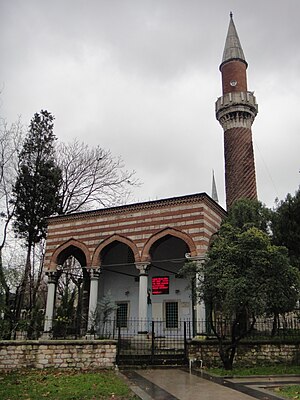
Burmalı Mosque
16th-century mosque in Istanbul
Distance: Approx. 252 meters
Latitude and longitude: 41.0146,28.9563
The Burmalı Mosque (Turkish: Burmalı Mescit or Burmalı Minare Camii; meaning "Mosque with the Spiral Minaret") is a 16th-century Ottoman mosque in Saraçhane park, Fatih district, Istanbul, Turkey. Built in 1550 on behalf of Emin Nuretti Efendi, qadi 'asker of Egypt, it is named for its spiraling (burmalı) brick minaret, a copy of a Seljuq design that is unique in Istanbul. The mosque is not domed, but has a pitched porch, which rests on four reused Byzantine Corinthian stone columns.

June 2016 Istanbul bombing
Distance: Approx. 314 meters
Latitude and longitude: 41.01334,28.95671
On 7 June 2016, at around 08:40 (UTC+3), a bombing occurred in central Istanbul, Turkey, killing 12 people and injuring 51 others, three of them seriously. The attack targeted a bus carrying policemen as the vehicle passed through the Vezneciler district near the Şehzade Mosque and the Vezneciler Metro station.
Battle of Constantinople (1241)
Naval battle
Distance: Approx. 201 meters
Latitude and longitude: 41.01388889,28.95555556
The Battle of Constantinople was a naval battle between the fleets of the Empire of Nicaea and the Republic of Venice that occurred in May–June 1241 near Constantinople.

İskenderpaşa
District in Istanbul, Turkey
Distance: Approx. 371 meters
Latitude and longitude: 41.01444444,28.94888889
İskenderpaşa is a neighbourhood in the municipality and district of Fatih, Istanbul Province, Turkey. Its population is 12,024 (2022). It is in the European part of Istanbul.
Weather in this IP's area
scattered clouds
22 Celsius
22 Celsius
21 Celsius
22 Celsius
1014 hPa
79 %
1014 hPa
1010 hPa
10000 meters
4.47 m/s
350 degree
40 %
06:38:06
19:25:51