Country:
Region:
City:
Latitude and Longitude:
Time Zone:
Postal Code:
IP information under different IP Channel
ip-api
Country
Region
City
ASN
Time Zone
ISP
Blacklist
Proxy
Latitude
Longitude
Postal
Route
Luminati
Country
Region
by
City
munich
ASN
Time Zone
Europe/Berlin
ISP
M-net Telekommunikations GmbH
Latitude
Longitude
Postal
IPinfo
Country
Region
City
ASN
Time Zone
ISP
Blacklist
Proxy
Latitude
Longitude
Postal
Route
db-ip
Country
Region
City
ASN
Time Zone
ISP
Blacklist
Proxy
Latitude
Longitude
Postal
Route
ipdata
Country
Region
City
ASN
Time Zone
ISP
Blacklist
Proxy
Latitude
Longitude
Postal
Route
Popular places and events near this IP address

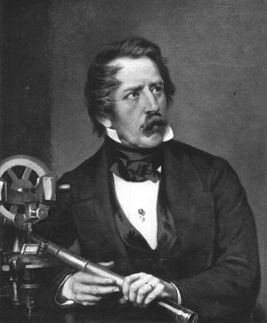
Carl August von Steinheil
German physicist
Distance: Approx. 541 meters
Latitude and longitude: 48.127222,11.565
Carl August von Steinheil (12 October 1801 – 14 September 1870) was a German physicist, inventor, engineer and astronomer.
Fraunhoferstraße station
Metro station in Munich, Germany
Distance: Approx. 730 meters
Latitude and longitude: 48.12916667,11.57416667
Fraunhoferstraße is an U-Bahn station in Munich on the U1 and U2. It is also served by route of the Munich tramway.

Kolumbusplatz station
Station of the Munich U-Bahn
Distance: Approx. 727 meters
Latitude and longitude: 48.11916667,11.57694444
Kolumbusplatz is an U-Bahn station in Munich on the U1 and U2 of the Munich U-Bahn system.

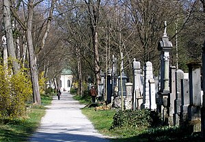
Alter Südfriedhof
Cemetery in Munich, Germany
Distance: Approx. 539 meters
Latitude and longitude: 48.1272,11.565
The Alter Südfriedhof (Old South Cemetery) also known as "Alter Südlicher Friedhof" is a cemetery in Munich, Germany. It was founded by Duke Albrecht V as a plague cemetery in 1563 about half a kilometer south of the Sendlinger Gate between Thalkirchner and Pestalozzistraße.

Ludwigsvorstadt-Isarvorstadt
Borough of Munich, Germany
Distance: Approx. 555 meters
Latitude and longitude: 48.12725212,11.56475794
Ludwigsvorstadt-Isarvorstadt (Central Bavarian: Ludwigsvorstod-Isarvorstod) is one of the boroughs of Munich, Germany. It consists of the districts Ludwigsvorstadt, located south of Munich Hauptbahnhof and east of the Theresienwiese, and Isarvorstadt, which is north-west of the River Isar and southeast of Munich's Old Town. The Lindwurmstraße serves as a divider for the two districts.

St. Stephan's Church, Munich
Church in Munich
Distance: Approx. 854 meters
Latitude and longitude: 48.13083333,11.56666667
St. Stephan's Church is a former cemetery church of the old South Cemetery in Munich, Germany. It is the chapel of the parish church of St Peter.

St. Maximilian, Munich
Distance: Approx. 475 meters
Latitude and longitude: 48.12666667,11.57361111
St. Maximilian is a Roman Catholic parish church of the Isar suburb in Munich, southern Germany. It was built from 1892 to 1908 under design by Heinrich von Schmidt in the Romanesque Revival style.

Nockherstraße
Distance: Approx. 844 meters
Latitude and longitude: 48.12028056,11.57985833
The Nockherstraße is a road located in the south of Au-Haidhausen, the 5th district of Munich, Germany. The former suburb of Au is located in the original flooding area of the Isar. The 500-meter-long road runs between the end of the Ohlmüllerstraße (beginning of the street Am Nockherberg) and the Kolumbusplatz at the foot of the Isar river terrace.
Angertorstraße 3
Apartment building in Munich, Germany
Distance: Approx. 881 meters
Latitude and longitude: 48.1313,11.5702
Angertorstraße 3 is an apartment building in Munich, Germany that is a registered Bavarian historical monument.
Müllerstraße
Street in Munich, Germany
Distance: Approx. 841 meters
Latitude and longitude: 48.130921,11.57057
The Müllerstraße is a 700-meter-long street in the Munich Glockenbachviertel.
Blumenstraße 29
Historical building in Munich, Germany
Distance: Approx. 924 meters
Latitude and longitude: 48.13166,11.57076
The building at Blumenstraße 29 in Munich is a guest and rental house. It is registered as a historical monument building in the Bavarian List of Monuments.

Wittelsbacherbrücke
Bridge in Munich, Germany
Distance: Approx. 154 meters
Latitude and longitude: 48.1227,11.56772
Wittelsbacherbrücke is an arched bridge in Munich, Germany, crossing the river Isar and connecting the districts of Isarvorstadt and Au.
Weather in this IP's area
scattered clouds
5 Celsius
5 Celsius
3 Celsius
6 Celsius
1026 hPa
94 %
1026 hPa
963 hPa
10000 meters
1.32 m/s
1.44 m/s
100 degree
49 %
07:11:42
16:43:31


