Country:
Region:
City:
Latitude and Longitude:
Time Zone:
Postal Code:
IP information under different IP Channel
ip-api
Country
Region
City
ASN
Time Zone
ISP
Blacklist
Proxy
Latitude
Longitude
Postal
Route
Luminati
Country
Region
by
City
munich
ASN
Time Zone
Europe/Berlin
ISP
M-net Telekommunikations GmbH
Latitude
Longitude
Postal
IPinfo
Country
Region
City
ASN
Time Zone
ISP
Blacklist
Proxy
Latitude
Longitude
Postal
Route
db-ip
Country
Region
City
ASN
Time Zone
ISP
Blacklist
Proxy
Latitude
Longitude
Postal
Route
ipdata
Country
Region
City
ASN
Time Zone
ISP
Blacklist
Proxy
Latitude
Longitude
Postal
Route
Popular places and events near this IP address

Upper Bavaria
Regierungsbezirk in Bavaria, Germany
Distance: Approx. 71 meters
Latitude and longitude: 48.13333333,11.56666667
Upper Bavaria (German: Oberbayern, pronounced [ˈoːbɐˌbaɪ̯ɐn] ; Bavarian: Oberbayern) is one of the seven administrative regions of Bavaria, Germany.

Bavarian Soviet Republic
1919 unrecognized socialist state in Bavaria, Germany
Distance: Approx. 71 meters
Latitude and longitude: 48.13333333,11.56666667
The Bavarian Soviet Republic (or Bavarian Council Republic), also known as the Munich Soviet Republic (German: Räterepublik Baiern, Münchner Räterepublik), was a short-lived unrecognised socialist state in Bavaria during the German revolution of 1918–1919. A group of communists and anarchists declared the Bavarian Soviet Republic on 6 April 1919, forcing the government of the existing People's State of Bavaria to flee to Bamberg. The members of the new government, led by playwright Ernst Toller, had no political or administrative experience, and after just six days in power they were ousted in a putsch organized by the Communist Party of Germany (KPD).

Kingdom of Bavaria
1806–1918 kingdom in Central Europe
Distance: Approx. 75 meters
Latitude and longitude: 48.1333,11.5667
The Kingdom of Bavaria (German: Königreich Bayern [ˈkøːnɪkʁaɪç ˈbaɪɐn]; Bavarian: Kinereich Bayern [ˈkɪnəraɪ̯x ˈb̥ajɛɐ̯n]; spelled Baiern until 1825) was a German state that succeeded the former Electorate of Bavaria in 1806 and continued to exist until 1918. With the unification of Germany into the German Empire in 1871, the kingdom became a federated state of the new empire and was second in size, power, and wealth only to the leading state, the Kingdom of Prussia. The polity's foundation dates back to the ascension of Elector Maximilian IV Joseph of the House of Wittelsbach as King of Bavaria in 1806.

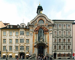
Asam Church, Munich
Baroque church in Munich, Germany
Distance: Approx. 312 meters
Latitude and longitude: 48.135,11.56944444
St. Johann Nepomuk, better known as the Asam Church (German: Asamkirche), is a Baroque church in Munich, southern Germany. It was built from 1733 to 1746 by a pair of brothers, sculptor Egid Quirin Asam and painter Cosmas Damian Asam, as their private church.

Sendlinger Tor station
Station of the Munich U-Bahn
Distance: Approx. 53 meters
Latitude and longitude: 48.13333333,11.56638889
Sendlinger Tor is an U-Bahn station in the city center of Munich at a junction of the lines U1/2/7 and U3/6 line of the Munich U-Bahn system. It was opened on 19 October 1971 (upper level, U3 and U6) and 18 October 1980 (lower level, U1, U2 and U7). Above ground, the station is served by routes , , and of the Munich tramway.

Sendlinger Tor
City gate in Munich, Germany
Distance: Approx. 141 meters
Latitude and longitude: 48.133965,11.567624
The Sendlinger Tor (translated: Sendling Gate) is a city gate at the southern extremity of the historic old town area of Munich. It served as a fortification for defence and is one of Munich's three remaining gothic town gates (the other two being the Isartor and the Karlstor).

Bavaria-Munich
Duchy part of the Holy Roman Empire
Distance: Approx. 71 meters
Latitude and longitude: 48.13333333,11.56666667
Bavaria-Munich (Middle High German: Baiern-Münichen) was a duchy that was a constituent state of the Holy Roman Empire from 1392 to 1505.
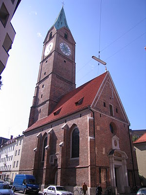
Kreuzkirche, Munich
Distance: Approx. 275 meters
Latitude and longitude: 48.13555556,11.56805556
The Church of All Saints (German: Allerheiligenkirche) also known as Holy Cross Church (German: Kreuzkirche), is a cemetery church in Munich, southern Germany. The church was built in 1478 by Jörg von Halsbach and was the first church with a cemetery in the St. Peter parish.
Volleyballhalle
Distance: Approx. 75 meters
Latitude and longitude: 48.1333,11.5667
Volleyballhalle is an indoor arena located in Munich, Germany. It hosted the volleyball competitions for the 1972 Summer Olympics in Munich. The hall has an area of 5132 square meters and included a restaurant, restrooms, and changing area.

St. Stephan's Church, Munich
Church in Munich
Distance: Approx. 315 meters
Latitude and longitude: 48.13083333,11.56666667
St. Stephan's Church is a former cemetery church of the old South Cemetery in Munich, Germany. It is the chapel of the parish church of St Peter.

Isar Klinikum
Hospital in Bavaria, Germany
Distance: Approx. 165 meters
Latitude and longitude: 48.134998,11.565048
The Isar Klinikum (Own Spelling: ISAR Klinikum) was founded by Eckhard Alt in 2008 and is located on the Munich Altstadtring.

People's State of Bavaria
State in Bavaria, Germany during the revolutions of 1918–1919
Distance: Approx. 71 meters
Latitude and longitude: 48.13333333,11.56666667
The People's State of Bavaria (German: Volksstaat Bayern) was a republic in Bavaria from 1918 to 1919. The People's State of Bavaria was established on 8 November 1918 during the German Revolution, as an attempt at a socialist state to replace the Kingdom of Bavaria. The state was led by Kurt Eisner until his assassination in February 1919.
Weather in this IP's area
broken clouds
5 Celsius
5 Celsius
3 Celsius
5 Celsius
1026 hPa
93 %
1026 hPa
963 hPa
10000 meters
0.45 m/s
1.34 m/s
44 degree
51 %
07:11:45
16:43:31
