Country:
Region:
City:
Latitude and Longitude:
Time Zone:
Postal Code:
IP information under different IP Channel
ip-api
Country
Region
City
ASN
Time Zone
ISP
Blacklist
Proxy
Latitude
Longitude
Postal
Route
Luminati
Country
ASN
Time Zone
Europe/Kyiv
ISP
User Association of Ukrainian Research and Academic Network URAN
Latitude
Longitude
Postal
IPinfo
Country
Region
City
ASN
Time Zone
ISP
Blacklist
Proxy
Latitude
Longitude
Postal
Route
db-ip
Country
Region
City
ASN
Time Zone
ISP
Blacklist
Proxy
Latitude
Longitude
Postal
Route
ipdata
Country
Region
City
ASN
Time Zone
ISP
Blacklist
Proxy
Latitude
Longitude
Postal
Route
Popular places and events near this IP address

Kyiv Polytechnic Institute
Public technological university in Kyiv, Ukraine
Distance: Approx. 290 meters
Latitude and longitude: 50.44972222,30.46083333
Kyiv Polytechnic Institute (official long title as National Technical University of Ukraine "Igor Sikorsky Kyiv Polytechnic Institute") is a public technological university in Kyiv, Ukraine.

Kyiv Zoo
Zoo in Kyiv, Ukraine
Distance: Approx. 732 meters
Latitude and longitude: 50.45416667,30.46277778
The Kyiv Zoo (Ukrainian: Київський Зоопарк, romanized: Kyyivsʹkyy Zoopark) is the only large zoo in Kyiv, Ukraine and one of the largest zoos in the former Soviet Union. Situated on about 40 hectares (99 acres), the zoo is cared for by 378 staff members and receives about 280,000 visitors annually.
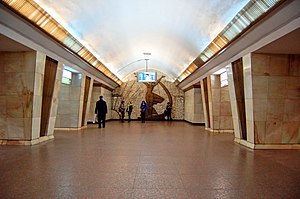
Politekhnichnyi Instytut (Kyiv Metro)
Kyiv Metro Station
Distance: Approx. 425 meters
Latitude and longitude: 50.45083333,30.46638889
Politekhnichnyi Instytut (Ukrainian: Політехнічний інститут, ) is a station on Kyiv Metro's Sviatoshynsko-Brovarska Line. The station was opened on 5 November 1963, and is named after Kyiv's Polytechnic Institute located near the station. It was designed by G.V. Golovko, B.V. Dzbanovsky, E.L. Ivanov, and M.M. Syrkin.
International Solomon University
Private university in Kyiv, Ukraine
Distance: Approx. 1107 meters
Latitude and longitude: 50.452,30.4772
International Solomon University (ISU) is a non-governmental higher education institution in Ukraine. It was founded in 1991. In 1991-1994 Professor Alexander Tetelbaum was the President-founder of ISU. Teaching at the ISU begun on September 1, 1993.

CSK ZSU Stadium
Multi-use stadium in Kyiv, Ukraine
Distance: Approx. 1120 meters
Latitude and longitude: 50.44472222,30.47833333
CSK ZSU Stadium (Ukrainian: Стадіон ЦСК ЗСУ) is a multi-use stadium in Kyiv, Ukraine. It is often used for football matches and was the home of FC CSKA Kyiv. The stadium holds 12,000 spectators and it opened in 1967.

Sky Towers (Kyiv)
Building in Kyiv, Ukraine
Distance: Approx. 981 meters
Latitude and longitude: 50.44861111,30.47694444
The Sky Towers Multifunctional Complex is a mixed-use building currently on hold in Kyiv, the capital of Ukraine. The project is designed to have two towers, ranging from 34 to 47 stories, and a two-story bank building. The gross area of the complex will be approximately 225,000 square meters.

Karavaievi Dachi railway station
Railway station in Kyiv, Ukraine
Distance: Approx. 1463 meters
Latitude and longitude: 50.438075,30.44897778
Karavaievi Dachi is railway station in Kyiv, Ukraine. It is served by local Ukrzaliznytsia trains Kyivpastrans' Kyiv Urban Rail. The station's name comes from the historic neighborhood where it is located.
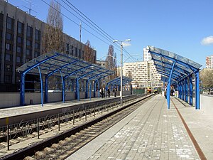
Oleksy Tykhoho (Kyiv Light Rail)
Kyiv Light Rail station
Distance: Approx. 597 meters
Latitude and longitude: 50.44638889,30.455
Oleksy Tykhoho (Ukrainian: Олекси Тихого; until 2020, Poliova) is a station on the Kyiv Light Rail. It was opened in 1977.

Politekhnichna (Kyiv Light Rail)
Kyiv Light Rail station
Distance: Approx. 298 meters
Latitude and longitude: 50.44638889,30.46694444
Politekhnichna (Ukrainian: Політехнічна) is a station on the Kyiv Light Rail. It was opened in 1978.

Ministry of Defence building (Ukraine)
Distance: Approx. 1238 meters
Latitude and longitude: 50.443,30.4791
The Ministry of Defence building is a government building in Kyiv that houses the Ministry of Defence of Ukraine. The building, originally constructed as the Vladimir Cadet Corps, was built to the design of Russian architect Ivan Shtrom.
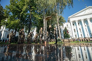
Hall of Remembrance, Kyiv
Mamorial site in Ukraine
Distance: Approx. 1247 meters
Latitude and longitude: 50.4428,30.4791
The Hall of Remembrance (Ukrainian: Зала пам'яті, romanized: Zala pamyati) is a memorial complex in Kyiv, on the site of the Ministry of Defense of Ukraine. The complex honors the fallen servicemen of the Armed Forces of Ukraine and other Ukrainian military, law enforcement units, and volunteers who died in the battles for Ukraine.
Povitrianykh Syl Avenue
Street in Kyiv, Ukraine
Distance: Approx. 1300 meters
Latitude and longitude: 50.44611111,30.48138889
Povitrianykh Syl Avenue is a street located in Shevchenko Raion and Solomianka Raion of Kyiv. It runs from Viacheslava Chornovola Street to Kyiv International Airport.
Weather in this IP's area
light snow
2 Celsius
2 Celsius
1 Celsius
3 Celsius
1015 hPa
84 %
1015 hPa
997 hPa
335 meters
0.45 m/s
1.79 m/s
246 degree
100 %
07:12:55
16:12:53
