Country:
 Italy
ItalyRegion:
City:
Latitude and Longitude:
Time Zone:
Postal Code:
IP information under different IP Channel
ip-api
Country
Region
City
ASN
Time Zone
ISP
Blacklist
Proxy
Latitude
Longitude
Postal
Route
IPinfo
Country
Region
City
ASN
Time Zone
ISP
Blacklist
Proxy
Latitude
Longitude
Postal
Route
MaxMind
Country
Region
City
ASN
Time Zone
ISP
Blacklist
Proxy
Latitude
Longitude
Postal
Route
Luminati
Country
ITASN
Time Zone
Europe/Rome
ISP
IT.Gate S.p.A.
Latitude
Longitude
Postal
db-ip
Country
Region
City
ASN
Time Zone
ISP
Blacklist
Proxy
Latitude
Longitude
Postal
Route
ipdata
Country
Region
City
ASN
Time Zone
ISP
Blacklist
Proxy
Latitude
Longitude
Postal
Route
Popular places and events near this IP address

Perrero
Comune in Piedmont, Italy
Distance: Approx. 7076 meters
Latitude and longitude: 44.93333333,7.11666667
Perrero (Occitan: Lo Perrier, French: Le Perrier) is a comune (municipality) in the Metropolitan City of Turin in the Italian region Piedmont, located about 40 kilometres (25 mi) southwest of Turin. Perrero borders the following municipalities: Roure, Perosa Argentina, Massello, Pomaretto, Salza di Pinerolo, Prali, Pramollo, Angrogna, and Villar Pellice.

Valle Germanasca
Distance: Approx. 6546 meters
Latitude and longitude: 44.937045,7.121937
The Valle Germanasca is a valley in the Metropolitan City of Turin, Piedmont, north-western Italy run by the Germanasca stream, a right affluent of the Chisone. The valley, in the past affected by a strong depopulation, is now partially characterized by a tourist vocation, in particular for its landscape beauties. The main resort is Ghigo, a frazione of the comune of Prali, famous for its ski resort.

Val Chisone
Alpine valley in Piedmont (Italy)
Distance: Approx. 7255 meters
Latitude and longitude: 45,7.13333333
The Val Chisone is one of the Occitan valleys of western Piedmont, situated in the Cottian Alps in the Metropolitan City of Turin in north-west Italy.

Germanasca
River in Italy
Distance: Approx. 963 meters
Latitude and longitude: 44.95361111,7.18888889
The Germanasca (also in Piedmontese Germanasca) is a 27 km (17 mi) Italian torrent, which runs through the Metropolitan City of Turin. It is a tributary of the Chisone, into which it flows near Perosa Argentina. The valley formed by the river is known as Val Germanasca.
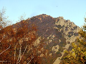
Monte Freidour
Mountain in Italy
Distance: Approx. 8339 meters
Latitude and longitude: 44.97301389,7.30374722
Monte Freidour is a mountain in the Cottian Alps, Metropolitan City of Turin in Piedmont, north-western Italy. It has an elevation of 1.451 m, with a secondary summit at 1,445 metres (4,741 ft), and is composed of gneiss cliffs overlooking the town of Cumiana.

Monte Tre Denti
Mountain in Italy
Distance: Approx. 9820 meters
Latitude and longitude: 44.97213056,7.32325
Monte Tre Denti (Italian: Mount Three Teeth) is peak in the Cottian Alps, Metropolitan City of Turin in Piedmont, north-western Italy. It has an elevation of 1,365 metres (4,478 ft) and is located between the comuni of Cumiana and Cantalupa. Together with the nearby Monte Freidour, it is part of a natural park called Parco naturale di interesse provinciale del Monte Tre Denti - Freidour.
Weather in this IP's area
overcast clouds
11 Celsius
11 Celsius
10 Celsius
12 Celsius
1014 hPa
94 %
1014 hPa
946 hPa
105 meters
0.83 m/s
1.04 m/s
111 degree
100 %
07:38:01
18:59:00