212.110.140.229 - IP Lookup: Free IP Address Lookup, Postal Code Lookup, IP Location Lookup, IP ASN, Public IP
Country:
Region:
City:
Location:
Time Zone:
Postal Code:
ISP:
ASN:
language:
User-Agent:
Proxy IP:
Blacklist:
IP information under different IP Channel
ip-api
Country
Region
City
ASN
Time Zone
ISP
Blacklist
Proxy
Latitude
Longitude
Postal
Route
db-ip
Country
Region
City
ASN
Time Zone
ISP
Blacklist
Proxy
Latitude
Longitude
Postal
Route
IPinfo
Country
Region
City
ASN
Time Zone
ISP
Blacklist
Proxy
Latitude
Longitude
Postal
Route
IP2Location
212.110.140.229Country
Region
avtonomna respublika krym
City
simferopol
Time Zone
Europe/Simferopol
ISP
Language
User-Agent
Latitude
Longitude
Postal
ipdata
Country
Region
City
ASN
Time Zone
ISP
Blacklist
Proxy
Latitude
Longitude
Postal
Route
Popular places and events near this IP address

Simferopol
Second-largest city on the Crimean Peninsula
Distance: Approx. 907 meters
Latitude and longitude: 44.95194444,34.10222222
Simferopol (), also known as Aqmescit, is the second-largest city on the Crimean Peninsula. The city, along with the rest of Crimea, is internationally recognised as part of Ukraine, controlled by Russia, and is considered the capital of the Autonomous Republic of Crimea. Since 2014 it has been under the de facto control of Russia, which annexed Crimea that year and regards Simferopol as the capital of the Republic of Crimea.

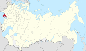
Taurida Governorate
1802–1918 unit of Russia
Distance: Approx. 1152 meters
Latitude and longitude: 44.9481,34.1042
Taurida Governorate was an administrative-territorial unit (guberniya) of the Russian Empire. It included the territory of the Crimean Peninsula and the mainland between the lower Dnieper River with the coasts of the Black Sea and Sea of Azov. It formed after the Taurida Oblast was abolished in 1802 during Paul I's administrative reform of the territories of the former Crimean Khanate, which were annexed by Russia from the Ottoman Empire in 1783.

Simferopol Municipality
Municipality in Crimea, Disputed:
Distance: Approx. 139 meters
Latitude and longitude: 44.958239,34.109745
Simferopol City Municipality (Ukrainian: Сімферопольська міськa рада, romanized: Simferopolska miska rada; Russian: Симферопольский горсовет, romanized: Simferopolskiy gorsovet; Crimean Tatar: Aqmescit şeer şurası, officially "the territory governed by the Simferopol city council") is one of the 25 regions of the Crimean peninsula in Ukraine currently occupied by Russia. Population: 352,363 (2014 Census).

State Council of Crimea
Regional parliament of the Republic of Crimea
Distance: Approx. 1266 meters
Latitude and longitude: 44.95166667,34.09694444
The State Council of Crimea is the parliament of the Russia-administered Republic of Crimea. It claims to be a continuation of the 'Supreme Council of Crimea' following a vote by the Ukrainian parliament to dissolve the Supreme Council of Crimea. The Parliament is housed in the Parliament building in the centre of Simferopol.

Fiolent Stadium
Football stadium in Ukraine
Distance: Approx. 626 meters
Latitude and longitude: 44.96094722,34.10485556
Fiolent, was the home ground of the now defunct Ukrainian football club of FC Ihroservice Simferopol. The ground opened for use on 1 April 1935. The former names it carried were Synie pole (Blue field), Kharchovyk (Food dealer), Avant-garde, Meteor.

Simferopol Raion
Raion in Crimea
Distance: Approx. 912 meters
Latitude and longitude: 44.9519,34.1022
Simferopol Raion (Ukrainian: Сімферопольський район, Russian: Симферопольский район, Crimean Tatar: Aqmescit rayonı) is one of the 25 regions of the Crimean peninsula, administered by Russia, but considered by many countries as part of Ukraine. The administrative center of the raion is the city of Simferopol which is incorporated as a town of republican significance and is not a part of the district. The Simferopol Raion is situated in the central part of the peninsula.

The Shot in the Back
Statue in Simferopol, Crimea
Distance: Approx. 817 meters
Latitude and longitude: 44.9525,34.10305556
The Shot in the Back (Ukrainian: По́стріл у спи́ну, Russian: Вы́стрел в спи́ну) is monument in Simferopol, Crimea, funded by Crimean residents and the Communist Party of Ukraine (KPU) to commemorate Ukrainian Soviet citizens and Red Army soldiers who were killed by the Ukrainian Insurgent Army (UPA) members during and after World War II. Standing 3.5 meters high, the monument was installed on Sovetskaya square. It was unveiled on 14 September 2007.

Kebir Mosque, Simferopol
Sunni mosque in Simferopol, Crimea
Distance: Approx. 987 meters
Latitude and longitude: 44.94888889,34.10694444
The Kebir Mosque (Russian: Кебир-Джами, Ukrainian: Кебір-Джамі, Crimean Tatar: Kebir Cami, Turkish: Kebir Camii, all transliterated as Kebir-Jami) is located in Simferopol, Crimea. The Kebir Mosque is a prominent architectural monument in Simferopol and the oldest building in the city.

Kyivskyi District, Simferopol
Urban district in Simferopol in Crimea, Disputed:
Distance: Approx. 1182 meters
Latitude and longitude: 44.95,34.1
Kyivskyi District (Russian: Киевский район; Ukrainian: Київський район) is an administrative raion (district) of the city of Simferopol. Population: 154,595 (2014 Census).

Zaliznychnyi District, Simferopol
Urban district in Simferopol in Crimea, Disputed:
Distance: Approx. 850 meters
Latitude and longitude: 44.95055556,34.10583333
Zaliznychnyi District (Ukrainian: Залізничний район; Russian: Железнодорожный район) is an administrative raion (district) of the city of Simferopol. Population: 78,022 (2014 Census).
Republic of Crimea (1992–1995)
Autonomous region of Ukraine
Distance: Approx. 884 meters
Latitude and longitude: 44.95211667,34.1024
The Republic of Crimea was the interim name of a polity on the Crimean peninsula from the dissolution of the Crimean Autonomous Soviet Socialist Republic in 1992 to the abolition of the Crimean Constitution by the Ukrainian Parliament in 1995. This period was one of conflict with the Ukrainian government over the levels of autonomy that Crimea enjoyed in relation to Ukraine, and links between Crimea and the Russian Federation.

Old Simferopol
Area of Simferopol in Autonomous Republic of Crimea, Ukraine
Distance: Approx. 1118 meters
Latitude and longitude: 44.9475,34.10777778
Old Simferopol, known locally as the Old Town (Crimean Tatar: Eski şeer, Ukrainian: Старе місто), is an area of the city of Simferopol which until the end of the 18th century served as the centre of the city of Aqmescit. The old town consists of narrow, short streets constructed in a traditional Turkic style. In the 19th century it was also referred to by travellers as the "Asian town" because of the contrast with Simferopol's other regular, European-style neighbourhoods.
Weather in this IP's area
overcast clouds
-2 Celsius
-2 Celsius
-2 Celsius
-2 Celsius
1030 hPa
91 %
1030 hPa
989 hPa
10000 meters
0.77 m/s
0.73 m/s
47 degree
88 %