212.104.13.120 - IP Lookup: Free IP Address Lookup, Postal Code Lookup, IP Location Lookup, IP ASN, Public IP
Country:
 Italy
ItalyRegion:
City:
Location:
Time Zone:
Postal Code:
ISP:
ASN:
language:
User-Agent:
Proxy IP:
Blacklist:
IP information under different IP Channel
ip-api
Country
Region
City
ASN
Time Zone
ISP
Blacklist
Proxy
Latitude
Longitude
Postal
Route
db-ip
Country
Region
City
ASN
Time Zone
ISP
Blacklist
Proxy
Latitude
Longitude
Postal
Route
IPinfo
Country
Region
City
ASN
Time Zone
ISP
Blacklist
Proxy
Latitude
Longitude
Postal
Route
IP2Location
212.104.13.120Country
itRegion
emilia-romagna
City
san giovanni
Time Zone
Europe/Rome
ISP
Language
User-Agent
Latitude
Longitude
Postal
ipdata
Country
Region
City
ASN
Time Zone
ISP
Blacklist
Proxy
Latitude
Longitude
Postal
Route
Popular places and events near this IP address
Carpi, Emilia-Romagna
Comune in Emilia-Romagna, Italy
Distance: Approx. 7537 meters
Latitude and longitude: 44.78333333,10.88333333
Carpi (Italian: [ˈkarpi]; Emilian: Chèrp) is an Italian town and comune of about 71,000 inhabitants in the province of Modena, Emilia-Romagna. It is a busy centre for industrial and craft activities and for cultural and commercial exchanges.

Blufin
Distance: Approx. 6768 meters
Latitude and longitude: 44.78983333,10.879
Blufin S.p.A. is an Italian fashion house founded by Anna Molinari and her late husband Gianpaolo Tarabini. The core brand is Blumarine, which they started in 1977, followed by Miss Blumarine (1987, 8- to 14-year-old girls), Blugirl (1995, for teenagers) and Anna Molinari (1995), which is being repositioned as their luxury brand.

Fabbrico
Comune in Emilia-Romagna, Italy
Distance: Approx. 5581 meters
Latitude and longitude: 44.86666667,10.8
Fabbrico (Reggiano: Fâbrich or Fâvrich; locally Fàvregh) is a comune (municipality) in the Province of Reggio Emilia in the Italian region Emilia-Romagna, located about 60 kilometres (37 mi) northwest of Bologna and about 25 kilometres (16 mi) northeast of Reggio Emilia. Fabbrico borders the following municipalities: Campagnola Emilia, Carpi, Reggiolo, Rio Saliceto, Rolo.

Rio Saliceto
Comune in Emilia-Romagna, Italy
Distance: Approx. 6442 meters
Latitude and longitude: 44.81666667,10.8
Rio Saliceto (Reggiano: Rée) is a comune (municipality) in the Province of Reggio Emilia in the Italian region Emilia-Romagna, located about 60 kilometres (37 mi) northwest of Bologna and about 20 kilometres (12 mi) northeast of Reggio Emilia. The name derives from the canal (Rio), which divided the territory with that of Carpi, and the marsh willows that grow in the area (Saliceto). Along with the neighbouring municipalities of Campagnola Emilia, Carpi, Correggio, Fabbrico and Rolo, it is a member of the Pianura Reggiana Union of Municipalities.

Rolo, Emilia-Romagna
Comune in Emilia-Romagna, Italy
Distance: Approx. 3938 meters
Latitude and longitude: 44.88333333,10.85
Rolo (Reggiano: Rôl or Rōl) is a comune (municipality) in the Province of Reggio Emilia in the Italian region Emilia-Romagna, located about 60 kilometres (37 mi) northwest of Bologna and about 25 kilometres (16 mi) northeast of Reggio Emilia. Rolo borders the following municipalities: Carpi, Fabbrico, Moglia, Novi di Modena, Reggiolo.
Battle of Carpi (1815)
1815 battle during the Neapolitan War
Distance: Approx. 7377 meters
Latitude and longitude: 44.784361,10.879572
The Battle of Carpi took place during the Neapolitan War between a brigade of Neapolitan soldiers under the command of Guglielmo Pepe and an Austrian force under the command of Baron Frimont. The battle took place in the town of Carpi and resulted in an Austrian victory, with the Neapolitans being driven from the town.
Roman Catholic Diocese of Carpi
Roman Catholic diocese in Italy
Distance: Approx. 7564 meters
Latitude and longitude: 44.7833,10.885
The Diocese of Carpi (Latin: Dioecesis Carpensis) is a Latin diocese of the Catholic Church in Emilia Romagna, Italy. It is a suffragan of the Archdiocese of Modena-Nonantola.
Fossoli camp
WWII concentration camp in Italy
Distance: Approx. 3732 meters
Latitude and longitude: 44.82833333,10.90277778
The Fossoli camp (Italian: Campo di Fossoli) was a concentration camp in Italy, established during World War II and located in the village of Fossoli, Carpi, Emilia-Romagna. It began as a prisoner of war camp in 1942, later being a Jewish concentration camp, then a police and transit camp, a labour collection centre for Germany and, finally, a refugee camp before closing in 1970. It is estimated that 2,844 Jews passed through this camp, 2,802 of whom were then deported.

Santa Maria in Castello, Carpi
Distance: Approx. 7650 meters
Latitude and longitude: 44.78273,10.88653
The parish church (Pieve) of Santa Maria in Castello, also known as the Chiesa della Sagra is a Romanesque style church in the city of Carpi, near Modena, Italy. It is remarkable for its Romanesque sculpted pulpit and portal, attributed to the school of Benedetto Antelami. The church was consecrated in 1184.

San Bernardino da Siena, Carpi
Distance: Approx. 7767 meters
Latitude and longitude: 44.7811,10.8822
San Bernardino da Siena and the adjacent Capuchin order Monastery are a Roman Catholic, Baroque style church and convent respectively, located on Via Trento Trieste 20 in central Carpi, Emilia-Romagna, Italy. San Bernardino da Siena is the patron saint of Carpi.
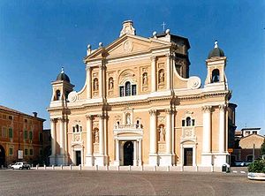
Carpi Cathedral
Distance: Approx. 7403 meters
Latitude and longitude: 44.78496,10.88626
Carpi Cathedral (Italian: Duomo di Carpi; Basilica cattedrale di Santa Maria Assunta) is a Roman Catholic cathedral in Carpi, Emilia-Romagna, Italy, dedicated to the Assumption of the Virgin Mary. It is the episcopal seat of the Diocese of Carpi. It stands on the site of a mediaeval pieve dedicated to Mary.

Fossoli
Frazione in Emilia-Romagna, Italy
Distance: Approx. 3609 meters
Latitude and longitude: 44.82222222,10.89027778
Fossoli (Emilian: Fòsel) is an Italian village and hamlet (frazione) of Carpi, a city and municipality of the province of Modena, Emilia-Romagna. It is infamous for the eponymous concentration camp and has a population of about 4400.
Weather in this IP's area
overcast clouds
5 Celsius
3 Celsius
4 Celsius
5 Celsius
1030 hPa
83 %
1030 hPa
1029 hPa
10000 meters
2.04 m/s
3.49 m/s
75 degree
100 %