211.120.219.137 - IP Lookup: Free IP Address Lookup, Postal Code Lookup, IP Location Lookup, IP ASN, Public IP
Country:
Region:
City:
Location:
Time Zone:
Postal Code:
IP information under different IP Channel
ip-api
Country
Region
City
ASN
Time Zone
ISP
Blacklist
Proxy
Latitude
Longitude
Postal
Route
Luminati
Country
Region
18
City
sata
ASN
Time Zone
Asia/Tokyo
ISP
NTT BUSINESS SOLUTIONS CORPORATION
Latitude
Longitude
Postal
IPinfo
Country
Region
City
ASN
Time Zone
ISP
Blacklist
Proxy
Latitude
Longitude
Postal
Route
IP2Location
211.120.219.137Country
Region
fukui
City
mikata
Time Zone
Asia/Tokyo
ISP
Language
User-Agent
Latitude
Longitude
Postal
db-ip
Country
Region
City
ASN
Time Zone
ISP
Blacklist
Proxy
Latitude
Longitude
Postal
Route
ipdata
Country
Region
City
ASN
Time Zone
ISP
Blacklist
Proxy
Latitude
Longitude
Postal
Route
Popular places and events near this IP address

Mihama, Fukui
Town in Chūbu, Japan
Distance: Approx. 5312 meters
Latitude and longitude: 35.60061111,135.94058333
Mihama (美浜町, Mihama-chō) is a town located in Fukui Prefecture, Japan. As of 1 May 2018, the city had an estimated population of 9,643 in 3175 households and the population density of 63 persons per km2. The total area of the town was 152.35 square kilometres (58.82 sq mi).

Mikatakaminaka District, Fukui
Distance: Approx. 4679 meters
Latitude and longitude: 35.521,135.891
Mikatakaminaka (三方上中郡, Mikatakaminaka-gun) is a district located in Fukui Prefecture, Japan. The district was formed on March 31, 2005 at the same time as the merger of the towns of Mikata (from Mikata District) and Kaminaka (from Onyū District) forming the town of Wakasa. As of October 1, 2020, the district has an estimated population of 14,003 and a density of 78.45 persons per km2.

Wakasa, Fukui
Town in Chūbu, Japan
Distance: Approx. 1277 meters
Latitude and longitude: 35.54894444,135.90816667
Wakasa (若狭町, Wakasa-chō) is a town located in Fukui Prefecture, Japan. As of 1 April 2018, the city had an estimated population of 14,577 and the population density of 82 persons per km2. The total area of the town was 178.49 square kilometres (68.92 sq mi).
Mihama Station
Railway station in Mihama, Fukui Prefecture, Japan
Distance: Approx. 5554 meters
Latitude and longitude: 35.605,135.9365
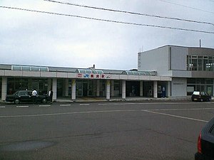
Mihama Station (美浜駅, Mihama-eki) is a railway station in the town of Mihama, Mikata District, Fukui Prefecture, Japan, operated by West Japan Railway Company (JR West).
Kiyama Station (Fukui)
Railway station in Wakasa, Fukui Prefecture, Japan
Distance: Approx. 2751 meters
Latitude and longitude: 35.5851,135.9098
Kiyama Station (気山駅, Kiyama-eki) is a railway station in the town of Wakasa, Mikatakaminaka District, Fukui Prefecture, Japan, operated by West Japan Railway Company (JR West).
Mikata Station
Railway station in Wakasa, Fukui Prefecture, Japan
Distance: Approx. 547 meters
Latitude and longitude: 35.5555,135.9094
Mikata Station (三方駅, Mikata-eki) is a railway station in the town of Wakasa, Mikatakaminaka District, Fukui Prefecture, Japan, operated by West Japan Railway Company (JR West).

Fujii Station
Railway station in Wakasa, Fukui Prefecture, Japan
Distance: Approx. 3171 meters
Latitude and longitude: 35.532,135.9063
Fujii Station (藤井駅, Fujii-eki) is a railway station in the town of Wakasa, Mikatakaminaka District, Fukui Prefecture, Japan, operated by West Japan Railway Company (JR West).
Tomura Station
Railway station in Wakasa, Fukui Prefecture, Japan
Distance: Approx. 5067 meters
Latitude and longitude: 35.516,135.8967
Tomura Station (十村駅, Tomura-eki) is a railway station in the town of Wakasa, Mikatakaminaka District, Fukui Prefecture, Japan, operated by West Japan Railway Company (JR West).

Ōtoba Station (Fukui)
Railway station in Wakasa, Fukui Prefecture, Japan
Distance: Approx. 7289 meters
Latitude and longitude: 35.5047,135.8667
Ōtoba Station (大鳥羽駅, Ōtoba-eki) is a railway station in the town of Wakasa, Mikatakaminaka District, Fukui Prefecture, Japan, operated by West Japan Railway Company (JR West).

Lake Suigetsu
Lake in Wakasa, Japan
Distance: Approx. 3452 meters
Latitude and longitude: 35.58333333,135.88333333
Lake Suigetsu (水月湖, Suigetsu-ko) is a lake in the Hokuriku region of Honshu, Japan, which is one of the Mikata Five Lakes located in Mihama and Wakasa, Fukui Prefecture (west-central Honshu), close to the coast of the Wakasa Bay in the Sea of Japan. Since 1993, it has been attracting the attention of scientists because of the undisturbed nature of the water for many thousands of years. It is possible to identify the annual deposits of silt in a similar manner that tree rings are identified.
Torihama shell mound
Ancient settlement remains in Japan
Distance: Approx. 1178 meters
Latitude and longitude: 35.56,135.896
The Torihama shell mound (鳥浜貝塚, Torihama kaizuka) is a shell midden and remains of an Early Jōmon period settlement located in the Torihama neighbourhood of the town of Wakasa, Fukui, in the Hokuriku region of Japan. It is a waterlogged midden site that was occupied mainly from the Incipient Jomon period to the Early Jomon period from 12,000 to 5,000 years ago (10,000–3,000 BC). The site is located in the area of Lake Mikata, one of the Mikata five lakes, near the confluence of Hasu and Takase Rivers, within the borders of the Wakasa Wan Quasi-National Park.

Mikata Five Lakes
Distance: Approx. 2582 meters
Latitude and longitude: 35.57219444,135.88444444
Mikata Five Lakes (Japanese: 三方五湖(みかたごこ), Hepburn: Mikata-goko), also called the Five Lakes of Mikata, are a series of brackish and freshwater lakes located in Mihama and Wakasa, Fukui, Japan, which are close to the coast of Wakasa Bay. They consist of Lakes Mikata (三方湖), Suigetsu (水月湖), Suga (菅湖), Kugushi (久々子湖) and Hiruga (日向湖). These five lakes are all located in Wakasa Wan Quasi-National Park.
Weather in this IP's area
light rain
9 Celsius
7 Celsius
9 Celsius
9 Celsius
1011 hPa
67 %
1011 hPa
985 hPa
10000 meters
3.78 m/s
6.28 m/s
146 degree
100 %


