Country:
 Iraq
IraqRegion:
City:
Latitude and Longitude:
Time Zone:
Postal Code:
IP information under different IP Channel
ip-api
Country
Region
City
ASN
Time Zone
ISP
Blacklist
Proxy
Latitude
Longitude
Postal
Route
IPinfo
Country
Region
City
ASN
Time Zone
ISP
Blacklist
Proxy
Latitude
Longitude
Postal
Route
MaxMind
Country
Region
City
ASN
Time Zone
ISP
Blacklist
Proxy
Latitude
Longitude
Postal
Route
Luminati
Country
 HK
HKASN
Time Zone
Asia/Hong_Kong
ISP
Ses Astra S.A.
Latitude
Longitude
Postal
db-ip
Country
Region
City
ASN
Time Zone
ISP
Blacklist
Proxy
Latitude
Longitude
Postal
Route
ipdata
Country
Region
City
ASN
Time Zone
ISP
Blacklist
Proxy
Latitude
Longitude
Postal
Route
Popular places and events near this IP address
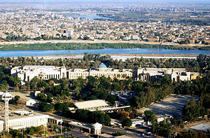
Baghdad
Capital of Iraq
Distance: Approx. 9 meters
Latitude and longitude: 33.31527778,44.36611111
Baghdad ( BAG-dad or bəg-DAD; Arabic: بَغْدَاد, romanized: Baghdād, [baɣˈdaːd] ) is the capital and largest city of Iraq. Situated on the Tigris, it is part of the Baghdad Governorate and is located near the Diyala River. With a population variously estimated at 6 or over 7 million, Baghdad forms 22% of Iraq's total population.

Baghdad Zoo
Zoo in Baghdad, Iraq
Distance: Approx. 961 meters
Latitude and longitude: 33.314845,44.376417
The Baghdad Zoo is a 200-acre (81 ha) zoo originally opened in 1971 and located in Baghdad, Iraq, in the Al Zawra’a Gardens area along with the Al Zawra’a Dream Park (amusement park) and Zawra'a Tower. Before the 2003 invasion of Iraq, the zoo housed 650 animals. After being nearly destroyed during the 2003 Iraqi war, when only about 35 animals survived, the zoo was reopened in 2003 and now houses about 1,070 animals.

Special Republican Guard (Iraq)
1992–2003 elite branch of Iraq's Republican Guard
Distance: Approx. 899 meters
Latitude and longitude: 33.309651,44.359075
The Iraqi Special Republican Guard (SRG) (Arabic: الحرس الجمهوري الخاص, romanized: al-Ḥaras al-ʿIrāq al-Jamhūrīy al-Khas), also known as the Special Forces Brigade of the Presidential Palace, Republican Guard Special Protection Forces, or the Golden Division, was an Iraqi personal security force founded in either early 1992 or March 1995 in Ba'athist-era Iraq. The Special Republican Guard was controlled by the Special Security Organization and charged with protecting President Saddam Hussein, presidential sites, Baghdad, and responding to any rebellion, coup, or other threat to his power.
Iraqi Intelligence Service
Government intelligence agency under Saddam Hussein
Distance: Approx. 899 meters
Latitude and longitude: 33.309651,44.359075
The Iraqi Intelligence Service (Arabic: جهاز المخابرات العامة العراقية, romanized: Jihaz Al-Mukhabarat Al-Eiraqii, lit. 'General Intelligence Directorate of Iraq') also known as the Mukhabarat, General Intelligence Directorate, or Party Intelligence, was an 8,000-man agency and the main state intelligence organization in Iraq under Saddam Hussein. The IIS was primarily concerned with international intelligence collection and analysis but also performed many activities inside Iraq in conjunction with the Directorate of General Security as a secret police organization. The most important section of the IIS was Directorate 4: the Secret Service.
Ministry of Electricity (Iraq)
Distance: Approx. 599 meters
Latitude and longitude: 33.32,44.369
The Ministry of Electricity of Iraq is the federal government ministry concerned with electricity. It is responsible for both the policymaking and the electricity supply throughout the country.

2007 Iraqi Parliament bombing
Terrorist attack in Baghdad, Iraq
Distance: Approx. 214 meters
Latitude and longitude: 33.3151,44.3638
On 12 April 2007, the canteen of the Council of Representatives of Iraq building was attacked by a suicide bomber, killing one to eight people and wounding 23 others. The attack, in the heavily fortified Green Zone of Baghdad, occurred ten minutes after the Council of Representatives had adjourned for lunch. It was on the first floor of the Baghdad Convention Center, which houses the parliament.
Al-Saher Ahmed Radhi Stadium
Distance: Approx. 193 meters
Latitude and longitude: 33.31666667,44.365
Al-Saher Ahmed Radhi Stadium (Arabic: ملعب الساحر احمد راضي, lit. 'Magician Ahmed Radhi Stadium') is a multi-use stadium in Baghdad, Iraq. It is used mostly for football matches and serves as the home stadium of Al-Karkh SC. The stadium holds 5,150 people.

Al Turath University College
Distance: Approx. 606 meters
Latitude and longitude: 33.31805556,44.36055556
Al-Turath University (Arabic: جامعة التراث) is a private Iraqi university and the oldest of such type in Iraq. Established in 1988 in the Mansour district of Baghdad, The name al-turath (التراث) means "heritage" or "tradition".
Ministry of Trade (Iraq)
Government ministry in Iraq
Distance: Approx. 691 meters
Latitude and longitude: 33.32138889,44.36666667
The Ministry of Trade (MoT; Arabic: وزارة التجارة) is the cabinet-level ministry of the Iraqi government responsible for regulating and facilitating trade activities in Iraq. It owns a conglomeration of state-owned enterprises and operates a nearly $6bn annual budget that provides a monthly public food distribution program for Iraqis. This conglomerate also manages the import of grain, seeds, and construction materials.
Ministry of Human Rights (Iraq)
Distance: Approx. 544 meters
Latitude and longitude: 33.32,44.365
The Ministry of Human Rights was a cabinet-level ministry within the government of Iraq between 2003 and 2015. The Ministry was created by the Coalition Provisional Authority when the Iraqi Governing Council was formed after the invasion of Iraq. The Ministry interested of human rights propaganda, Saddam regime victims, victims of terrorism rights, martyrs rights, prisoners rights and mass graves in Iraq.

Baghdad Mall
Shopping mall in Baghdad, Iraq
Distance: Approx. 384 meters
Latitude and longitude: 33.31194444,44.36472222
Baghdad Mall (Arabic: بغداد مول) is a multi-purpose building consisting of a shopping mall, a hotel and a medical centre. Located in Harthiya, Baghdad at the intersection between Damascus street and Al-Kindi street, it is one of the largest shopping malls in Baghdad. The multi-level shopping mall currently features over one hundred retail outlets, a thousand parking spaces, and contains dozens of restaurants and cafés.
Middle Technical University
Technical university in Baghdad, Iraq
Distance: Approx. 482 meters
Latitude and longitude: 33.3195,44.3655
Middle Technical University (Arabic: الجامعة التقنية الوسطى) is a technical university in Baghdad, the capital city of Iraq. It was originally formed as Al-Hikma University by the Iraqi American Society in 1955. It was nationalized by the Iraqi state in 1969.
Weather in this IP's area
clear sky
24 Celsius
23 Celsius
24 Celsius
24 Celsius
1012 hPa
27 %
1012 hPa
1007 hPa
10000 meters
1.03 m/s
10 degree
06:01:00
17:39:21