Country:
 Hong Kong (China)
Region:
City:
Latitude and Longitude:
Time Zone:
Postal Code:
IP information under different IP Channel
ip-api
Country
Region
City
ASN
Time Zone
ISP
Blacklist
Proxy
Latitude
Longitude
Postal
Route
IPinfo
Country
Region
City
ASN
Time Zone
ISP
Blacklist
Proxy
Latitude
Longitude
Postal
Route
MaxMind
Country
Region
City
ASN
Time Zone
ISP
Blacklist
Proxy
Latitude
Longitude
Postal
Route
Luminati
Country
HKASN
Time Zone
Asia/Hong_Kong
ISP
Pacific Internet Pte Ltd
Latitude
Longitude
Postal
db-ip
Country
Region
City
ASN
Time Zone
ISP
Blacklist
Proxy
Latitude
Longitude
Postal
Route
ipdata
Country
Region
City
ASN
Time Zone
ISP
Blacklist
Proxy
Latitude
Longitude
Postal
Route
Popular places and events near this IP address
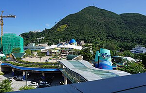
Ocean Park Hong Kong
Amusement park in Hong Kong
Distance: Approx. 94 meters
Latitude and longitude: 22.24586111,114.17591667
Ocean Park Hong Kong, commonly known simply as Ocean Park, is an animal theme park in Hong Kong. Covering an area of 91.5 hectares (226 acres) in Wong Chuk Hang, it is the largest theme park by area in Hong Kong, and is also the city's second oldest theme park, after the now-defunct Lai Chi Kok Amusement Park. Opened on 10 January 1977, Ocean Park became popular, but 28 years later, it was unprofitable and widely expected to close due to the new Hong Kong Disneyland.

Nam Long Shan
Hill in Aberdeen, Hong Kong
Distance: Approx. 843 meters
Latitude and longitude: 22.24313,114.16878
Nam Long Shan (Chinese: 南朗山) or Brick Hill is a hill on the Hong Kong Island of Hong Kong, near Wong Chuk Hang and Aberdeen. At an elevation of 282 metres, it overlooks the South China Sea in the south, Sham Wan and Aberdeen Channel in the west, and Deep Water Bay in the east.

Wong Chuk Hang
Suburb in Southern District, Hong Kong
Distance: Approx. 876 meters
Latitude and longitude: 22.24818,114.16765
Wong Chuk Hang (Cantonese pronunciation: [wɔ̏ːŋ tsók̚ háːŋ]) is a neighbourhood in the Southern District of Hong Kong Island, in Hong Kong.

Shouson Hill
Distance: Approx. 477 meters
Latitude and longitude: 22.24847,114.18022
Shouson Hill (Chinese: 壽臣山) is a hill (148 m high) on the coast of Deep Water Bay east of Wong Chuk Hang, in Southern District, on Hong Kong Island in Hong Kong. North of the hill is an affluent residential area, which consists primarily of Shouson Hill Road, a loop off the main Wong Chuk Hang Road, together with a few side roads.

Grantham Hospital
Hospital in Hong Kong Island, Hong Kong
Distance: Approx. 572 meters
Latitude and longitude: 22.25108,114.17309
Grantham Hospital is a specialist cardiothoracic hospital located at Wong Chuk Hang and is part of the Hong Kong West Cluster. It is a tertiary referral centre providing specialist service in cardiothoracic surgery, cardiology, paediatric cardiology, tuberculosis & chest medicine and cardio-pulmonary infirmary. In 2003 and 2004, palliative medicine and acute geriatrics service were set up respectively after Nam Long Hospital has been closed down in December 2003.

Ocean Park station
MTR station on Hong Kong Island
Distance: Approx. 275 meters
Latitude and longitude: 22.2486,114.1743
Ocean Park (Chinese: 海洋公園; Cantonese Yale: Hóiyèung Gūngyún) is an MTR rapid transit station in Hong Kong on the eastern section of the South Island line, which serves Ocean Park Hong Kong and Wong Chuk Hang. The station opened on 28 December 2016 with the rest of the South Island line. It takes around 4 minutes to travel from Admiralty to Ocean Park station, which is 21 minutes faster than taking the Citybus route 629 from Admiralty station to Hong Kong Ocean Park.

Wong Chuk Hang station
MTR station on Hong Kong Island
Distance: Approx. 827 meters
Latitude and longitude: 22.248,114.1681
Wong Chuk Hang (Chinese: 黃竹坑) is an elevated MTR rapid transit station in Hong Kong on the eastern section of the South Island line, built on the Staunton Creek Nullah and off the old site of Wong Chuk Hang Estate in Staunton Creek (Chung Mei). It is named after the locality of the same name further east and serves residents in that area, as well as connects to a public transport interchange on a widened section of Heung Yip Road. A network of footbridges serves future commercial and residential areas, and the station exists as a hub to the Shum Wan area as a whole.
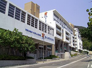
Hong Kong University Graduate Association College
Secondary school
Distance: Approx. 557 meters
Latitude and longitude: 22.251577,114.174776
Hong Kong University Graduate Association College or HKUGA College (HKUGAC; Chinese: 港大同學會書院) is a secondary school located at No. 9 Nam Fung Road, Wong Chuk Hang, Hong Kong.

Aberdeen Sports Ground
Sports ground in Hong Kong
Distance: Approx. 529 meters
Latitude and longitude: 22.250087,114.172398
Aberdeen Sports Ground (Chinese: 香港仔運動場) is a rugby union and football sports ground situated at 108 Wong Chuk Hang Road, Aberdeen, Hong Kong. It is the home stadium of Hong Kong Premier League football club Southern and Global Rapid Rugby rugby union team South China Tigers. Inside the stadium, there is one running track (6 lanes, 400m) and one natural grass pitch.
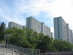
Wong Chuk Hang Estate
Distance: Approx. 768 meters
Latitude and longitude: 22.2453,114.1687
Wong Chuk Hang Estate (Chinese: 黃竹坑邨) was a public housing estate in Staunton Creek, Hong Kong. The estate had ten residential blocks and was cleared in 2007. The estate has been replaced by the MTR Wong Chuk Hang station and Wong Chuk Hang Depot.

Gleneagles Hospital Hong Kong
Hospital in Southern District, Hong Kong
Distance: Approx. 583 meters
Latitude and longitude: 22.2519,114.1767
Gleneagles Hospital Hong Kong (formerly Gleneagles Hong Kong Hospital) is a private multi-specialty district general hospital in Wong Chuk Hang, Hong Kong. The 500-bed hospital is a joint venture between Singapore-based Parkway Pantai and Hong Kong-listed NWS Holdings, with The University of Hong Kong being the hospital’s exclusive clinical partner. The hospital opened on 21 March 2017.
Wong Chuk Hang San Wai
Distance: Approx. 283 meters
Latitude and longitude: 22.249161,114.176695
Wong Chuk Hang San Wai (Chinese: 黃竹坑新圍; lit. 'Wong Chuk Hang new village') is a village in the Wong Chuk Hang area of Southern District, Hong Kong. It is located at the bottom of Shouson Hill.
Weather in this IP's area
broken clouds
29 Celsius
35 Celsius
27 Celsius
29 Celsius
1002 hPa
83 %
1002 hPa
999 hPa
10000 meters
1.79 m/s
80 degree
68 %
06:11:29
18:22:06