Country:
Region:
City:
Latitude and Longitude:
Time Zone:
Postal Code:
IP information under different IP Channel
ip-api
Country
Region
City
ASN
Time Zone
ISP
Blacklist
Proxy
Latitude
Longitude
Postal
Route
Luminati
Country
ASN
Time Zone
Asia/Shanghai
ISP
CHINA UNICOM Industrial Internet Backbone
Latitude
Longitude
Postal
IPinfo
Country
Region
City
ASN
Time Zone
ISP
Blacklist
Proxy
Latitude
Longitude
Postal
Route
db-ip
Country
Region
City
ASN
Time Zone
ISP
Blacklist
Proxy
Latitude
Longitude
Postal
Route
ipdata
Country
Region
City
ASN
Time Zone
ISP
Blacklist
Proxy
Latitude
Longitude
Postal
Route
Popular places and events near this IP address

People's Bank of China
Central bank of the People's Republic of China
Distance: Approx. 566 meters
Latitude and longitude: 39.90666667,116.35388889
The People's Bank of China (officially PBC and unofficially PBOC) is the central bank of the People's Republic of China. It is responsible for carrying out monetary policy as determined by the People's Bank Law and the Commercial Bank Law. The PBC was established in 1948 and became China's sole central bank after the founding of the People's Republic of China in 1949.

Xicheng, Beijing
District in Beijing, People's Republic of China
Distance: Approx. 86 meters
Latitude and longitude: 39.91,116.36
Xicheng (Chinese: 西城区; pinyin: Xīchéng Qū; lit. 'West City District') is a district of the city of Beijing. Its 32 square kilometers (12 sq mi) cover the western half of the old city (largely inside the 2nd Ring Road; the eastern half is Dongcheng District), and has 1,106,214 inhabitants (2020 Census).
Fuxingmen
Distance: Approx. 868 meters
Latitude and longitude: 39.90581389,116.35034444
Fuxingmen (simplified Chinese: 复兴门; traditional Chinese: 復興門; pinyin: Fùxīngmén) is the name of a gate that used to be a part of Beijing's old city wall. It is also the name of a road situated in central Beijing and on the northwestern stretch of the 2nd Ring Road.

Xidan
Region in Xicheng, Beijing
Distance: Approx. 795 meters
Latitude and longitude: 39.90755833,116.3678
Xidan (Chinese: 西单; Pinyin: Xīdān) is a major traditional commercial area in Beijing, China. It is located in the Xicheng District. The Xidan commercial district incorporates the Xidan Culture Square, North Xidan Street, as well as many supermarkets and department stores.

Fuxingmen Inner Street
Road in Beijing, China
Distance: Approx. 455 meters
Latitude and longitude: 39.9072,116.363
Fuxingmen Inner Street (simplified Chinese: 复兴门内大街; traditional Chinese: 復興門內大街; pinyin: Fùxīngmén Nèi Dàjiē) is a major street in urban Beijing. It forms part of the extended Chang'an Avenue. It starts at Fuxingmen Bridge in the west, finishing at West Chang'an Avenue in the east.

Peking Union Medical College Hospital
Hospital in Beijing, China
Distance: Approx. 896 meters
Latitude and longitude: 39.9139,116.3681
Peking Union Medical College Hospital (PUMCH), also known as Beijing Xiehe Hospital (Chinese: 北京协和医院), is a large teaching hospital in Beijing, China. It was founded in 1921 by the Rockefeller Foundation and is affiliated to both Peking Union Medical College (PUMC) and the Chinese Academy of Medical Sciences (CAMS). During the Cultural Revolution, it was renamed as the "Anti-Imperialist Hospital".

Nanlishi Lu station
Beijing Subway station
Distance: Approx. 623 meters
Latitude and longitude: 39.907234,116.352583
Nanlishi Lu Station (simplified Chinese: 南礼士路站; traditional Chinese: 南禮士路站; pinyin: Nánlǐshìlù Zhàn) is a station on Line 1 of the Beijing Subway.

Fuxingmen station (Beijing Subway)
Beijing Subway interchange station
Distance: Approx. 347 meters
Latitude and longitude: 39.907242,116.356866
Fuxingmen Station (simplified Chinese: 复兴门站; traditional Chinese: 復興門站; pinyin: Fùxīngmén Zhàn) is an interchange station on Line 1 and Line 2 of the Beijing Subway. It is named for Fuxingmen, a former gate in Beijing's city wall. The station handles over 170,000 transfers between Lines 1 and 2 per day.

Experimental High School Attached to Beijing Normal University
Public school in Beijing, China
Distance: Approx. 809 meters
Latitude and longitude: 39.9113,116.3683
The Experimental High School Attached to Beijing Normal University (北京师范大学附属实验中学) is a public secondary school in Xicheng, Beijing, China. The school is supervised by the Beijing City Xicheng District Education Committee. The school was founded in 1917 as the Girls' Middle School Attached to Beijing Girls' Normal School (北京女子师范学校附属中学).
Minzu Hotel
Large inn in Beijing
Distance: Approx. 419 meters
Latitude and longitude: 39.90642,116.360858
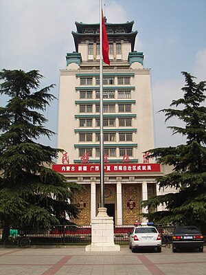
The Minzu Hotel (Chinese: 民族饭店; pinyin: Mínzú Fàndiàn, literally "Nationalities Hotel") is located on West Chang'an Avenue, in Xicheng District, Beijing, China. Opened in 1959, it was one of the Ten Great Buildings of Beijing in the 1950s, and has hosted numerous foreign delegations. It is also a common place for press conferences.
Cultural Palace of Nationalities
Museum and library complex in Beijing
Distance: Approx. 870 meters
Latitude and longitude: 39.90944444,116.36916667
The Cultural Palace of Nationalities (民族文化宫) is located in Beijing's Xicheng District, on West Chang'an Avenue. Built in September 1959, it is one of the Ten Great Buildings and was registered as the first of 55 museums in the city. The building houses a museum, an art gallery, a library, an art institute, a theater, a guesthouse, and other facilities.

Wanggongchang Explosion
1626 disaster in China
Distance: Approx. 1012 meters
Latitude and longitude: 39.9022,116.3653
The Wanggongchang Explosion (Chinese: 王恭廠大爆炸), also known as the Great Tianqi Explosion (天啟大爆炸), Wanggongchang Calamity (王恭廠之變) or Beijing Explosive Incident in the late Ming dynasty (晚明北京爆炸事件), was a catastrophic explosion that occurred on May 30, 1626, during the late reign of the Tianqi Emperor at the heavily populated Ming Chinese capital of Beijing, and reportedly killed around 20,000 people. The epicenter was a major production center of gunpowder, but it is uncertain exactly what triggered the explosion.
Weather in this IP's area
clear sky
5 Celsius
5 Celsius
5 Celsius
5 Celsius
1018 hPa
78 %
1018 hPa
1012 hPa
10000 meters
0.75 m/s
0.89 m/s
94 degree
06:59:34
16:58:57

