Country:
 South Korea
Region:
City:
Latitude and Longitude:
Time Zone:
Postal Code:
IP information under different IP Channel
ip-api
Country
Region
City
ASN
Time Zone
ISP
Blacklist
Proxy
Latitude
Longitude
Postal
Route
IPinfo
Country
Region
City
ASN
Time Zone
ISP
Blacklist
Proxy
Latitude
Longitude
Postal
Route
MaxMind
Country
Region
City
ASN
Time Zone
ISP
Blacklist
Proxy
Latitude
Longitude
Postal
Route
Luminati
Country
KRASN
Time Zone
Asia/Seoul
ISP
National Infomation Society Agency
Latitude
Longitude
Postal
db-ip
Country
Region
City
ASN
Time Zone
ISP
Blacklist
Proxy
Latitude
Longitude
Postal
Route
ipdata
Country
Region
City
ASN
Time Zone
ISP
Blacklist
Proxy
Latitude
Longitude
Postal
Route
Popular places and events near this IP address
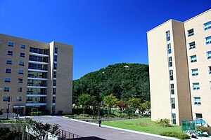
Seoul National University
Public university in Seoul, South Korea
Distance: Approx. 46 meters
Latitude and longitude: 37.46,126.9525
Seoul National University (SNU; Korean: 서울대학교; lit. Seoul University) is a public research university located in Seoul, South Korea. It is one of the SKY universities and a part of the Flagship Korean National Universities.

Kyujanggak
Former Korean royal library
Distance: Approx. 287 meters
Latitude and longitude: 37.462168,126.950444
Kyujanggak (Korean: 규장각; Hanja: 奎章閣), also known as Gyujanggak, was the royal library of the Joseon Dynasty. It was founded in 1776 by order of King Jeongjo of Joseon (as a major policy arm of his government), at which time it was located on the grounds of Changdeokgung Palace. Today known as Kyujanggak Royal Library, the Kyujanggak Archives are maintained by Kyujanggak Institute for Korean Studies at the Seoul National University, located in Sillim-dong, Gwanak-gu in Seoul.

Gwanaksan
Mountain in south Seoul, South Korea
Distance: Approx. 1898 meters
Latitude and longitude: 37.44555556,126.96361111
Gwanaksan (Korean: 관악산) is a mountain in southern Seoul, South Korea. Portions lie in the Gwanak District and Geumcheon District of Seoul; other portions lie in the neighboring cities of Anyang, Gyeonggi and Gwacheon. The name gwanak means "hat-shaped peak," and refers to its gat-like profile.
Gwanak District
Autonomous district in Seoul, South Korea
Distance: Approx. 2060 meters
Latitude and longitude: 37.4784,126.9516
Gwanak District (Korean: 관악구; RR: Gwanak-gu) is an administrative subdivision (gu) of Seoul, South Korea. It lies on the southern skirt of Seoul, bordering Anyang of Gyeonggi Province. The southern border of Gwanak District, bordering Anyang, consists of the craggy ridgeline of Gwanaksan (Mt.
Seoul National University Gymnasium
Distance: Approx. 850 meters
Latitude and longitude: 37.467527,126.952472
Seoul National University Gymnasium is an indoor sporting arena located in Seoul, South Korea. The capacity of the arena is 5,000 and was built in 1986 to host table tennis and badminton (demonstration) events at the 1988 Summer Olympics.

Seoul National University Museum of Art
Art museum of Seoul National University
Distance: Approx. 756 meters
Latitude and longitude: 37.4665,126.95
The Seoul National University Museum of Art (SNUMoA) is a museum in Seoul National University.

Bongcheon-dong
Neighborhood in Seoul, South Korea
Distance: Approx. 2134 meters
Latitude and longitude: 37.479,126.954
Bongcheon or Bongcheon-dong is a statutory division of Gwanak District, Seoul, South Korea. Its name means "enshrining heaven" which was derived from its location, northern skirt of Mt. Gwanak, stretching to the mountain ridge.
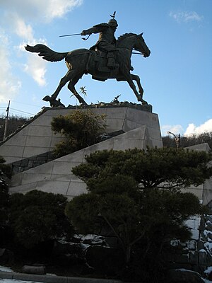
Nakseongdae
Park in Seoul, South Korea
Distance: Approx. 1444 meters
Latitude and longitude: 37.471223,126.959983
Nakseongdae (Korean pronunciation: [naks͈ʌŋdɛ]; Korean: 낙성대; Hanja: 落星垈) is a park located in Gwanak, Seoul. It is the birthplace of Goryeo general, Kang Kam-ch'an.

Anguksa (Seoul)
Shrine to Kang Kamch'an in South Korea
Distance: Approx. 1469 meters
Latitude and longitude: 37.47091944,126.96114722
Anguksa (Korean: 안국사) is a shrine located in Nakseongdae Park, Seoul, South Korea. It was built in 1973–74 to commemorate General Kang Kam-ch'an (948–1031). A memorial ceremony is held at the shrine every October to commemorate the general.
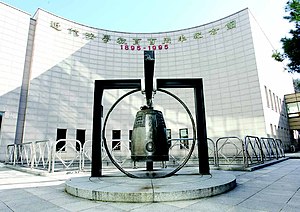
Seoul National University School of Law
Law school of Seoul National University
Distance: Approx. 291 meters
Latitude and longitude: 37.4625,126.95166667
Seoul National University School of Law (Korean: 서울대학교 법학전문대학원; SNU Law) is the law school of Seoul National University, a national research university in Gwanak, Seoul, South Korea. Following legacy of the only and the first modern national law school established in 1895 as 'Popkwan Yangsungso' (Korean: 법관양성소) for training judges, the SNU Law started its official history at 1946 in name of SNU College of Law, as one of college constituting the Seoul National University, offering continental styled legal education such as LL.B. courses for undergraduates. After nationwide legal education reform of South Korea in 2009, it adopted the American model of 3-year law school system, and changed its official name to SNU School of Law.

Gwanaksan station
Metro station in Seoul, South Korea
Distance: Approx. 1147 meters
Latitude and longitude: 37.46874,126.94533
Gwanaksan Station (Korean: 관악산역) is a subway station on the Sillim Line in Gwanak District, Seoul. It will be a transfer station with the Seoul Light Rail West Line in the future. From this station to Saetgang Station, all stations are underground.

Seoul National University Venture Town station
Metro station in Seoul, South Korea
Distance: Approx. 2097 meters
Latitude and longitude: 37.4719,126.9337
Seoul National University Venture Town Station is a station on the Sillim Line. It is located in Sillim-dong, Gwanak-gu, Seoul.
Weather in this IP's area
mist
12 Celsius
12 Celsius
11 Celsius
14 Celsius
1023 hPa
100 %
1023 hPa
1011 hPa
3000 meters
1.54 m/s
320 degree
100 %
06:41:52
17:52:53