210.112.91.19 - IP Lookup: Free IP Address Lookup, Postal Code Lookup, IP Location Lookup, IP ASN, Public IP
Country:
Region:
City:
Location:
Time Zone:
Postal Code:
IP information under different IP Channel
ip-api
Country
Region
City
ASN
Time Zone
ISP
Blacklist
Proxy
Latitude
Longitude
Postal
Route
Luminati
Country
ASN
Time Zone
Asia/Seoul
ISP
Digital Edge Korea
Latitude
Longitude
Postal
IPinfo
Country
Region
City
ASN
Time Zone
ISP
Blacklist
Proxy
Latitude
Longitude
Postal
Route
IP2Location
210.112.91.19Country
Region
sejong
City
sejong
Time Zone
ISP
Language
User-Agent
Latitude
Longitude
Postal
db-ip
Country
Region
City
ASN
Time Zone
ISP
Blacklist
Proxy
Latitude
Longitude
Postal
Route
ipdata
Country
Region
City
ASN
Time Zone
ISP
Blacklist
Proxy
Latitude
Longitude
Postal
Route
Popular places and events near this IP address

Sejong City
City in South Korea
Distance: Approx. 3 meters
Latitude and longitude: 36.487002,127.282234
Sejong or Sejong City (Korean: 세종; Korean: [seːdʑoŋ] ), officially Sejong Special Self-Governing City (세종특별자치시), is a special self-governing city and the de facto administrative capital of South Korea. Sejong was founded in 2007 as the new planned capital of South Korea from many parts of the South Chungcheong Province and some parts of North Chungcheong Province to ease congestion in South Korea's current capital and largest city, Seoul, and encourage investment in the country's central region. Since 2012, the government of South Korea has relocated numerous ministries and agencies to Sejong, but many still reside in other cities, primarily Seoul, where the National Assembly and many important government bodies remain.

Agency for Defense Development
South Korean military R&D agency
Distance: Approx. 8446 meters
Latitude and longitude: 36.4184077,127.3225271
The Agency for Defense Development (ADD, Korean: 국방과학연구소; Hanja: 國防科學硏究所; RR: Gukbang Gwahak Yeonguso) is the South Korean government agency for research and development in defense technology, funded by the Defense Acquisition Program Administration (DAPA). It was established in August 1970 under the banner of the self-reliant national defense promoted by President Park Chung Hee. Its purpose is contributing to enforcing the national defence, to improving the national R&D capacity, and to fostering the domestic defense industry.
Naepan station
Train station in South Korea
Distance: Approx. 8694 meters
Latitude and longitude: 36.55722222,127.32472222
Naepan station is a signal box on the Gyeongbu Line in Yeondong-myeon, Sejong City, South Korea.

Bugang station
Train station in South Korea
Distance: Approx. 8978 meters
Latitude and longitude: 36.53222222,127.36527778
Bugang station is a railway station on the Gyeongbu Line in Bugang-myeon, Sejong City, Republic of Korea.
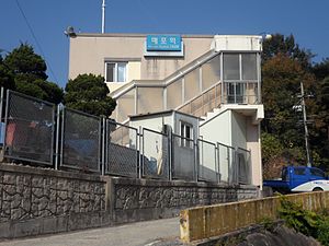
Maepo station
Train station in South Korea
Distance: Approx. 9812 meters
Latitude and longitude: 36.49888889,127.39083333
Maepo station is a railway station on the Gyeongbu Line in Bugang-myeon, Sejong City, South Korea.

Battle of Taejon
1950 battle of the Korean War
Distance: Approx. 1606 meters
Latitude and longitude: 36.47472222,127.27277778
The Battle of Taejon (16–20 July 1950) was an early battle of the Korean War, between U.S. and North Korean forces. Forces of the United States Army attempted to defend the headquarters of the 24th Infantry Division. The 24th Infantry Division was overwhelmed by numerically superior forces of the Korean People's Army (KPA) at the major city and transportation hub of Daejon (then spelt Taejon).
Chaplain–Medic massacre
1950 war crime during the Korean War
Distance: Approx. 6612 meters
Latitude and longitude: 36.4285,127.295
The Chaplain–Medic massacre took place in the Korean War on July 16, 1950, on a mountain above the village of Tuman (current Duman-ri, Geumnam-myeon, Sejong City). South Korean local natives claim that it took place on a mountain above the village of Yongdam-ri, which is next to Duman-ri. Thirty unarmed, critically wounded United States Army (US) soldiers and an unarmed chaplain were murdered by members of the Korean People's Army (KPA) during the Battle of the Kum River.
Miho River
Watercourse in South Korea
Distance: Approx. 4519 meters
Latitude and longitude: 36.51666667,127.31666667
Miho River (Korean: 미호강; Hanja: 美湖江), a tributary of Geum River, is a river beginning in Eumseong in North Chungcheong Province.

Sejong National Research Complex
Research facility in Sejong, South Korea
Distance: Approx. 2203 meters
Latitude and longitude: 36.4952,127.3046
The Sejong National Research Complex is a campus of four research buildings housing ten research institutes. Institutes started to relocate to the complex in 2014. It neighbors the Korea Institute of Public Finance (ko), Korea Legislation Research Institute (ko), and the Korea Research Institute for Human Settlements (ko) and is approximately 1.6 kilometers away from the Korea Development Institute.

RAON
Particle physics laboratory in South Korea
Distance: Approx. 8049 meters
Latitude and longitude: 36.4785,127.3715
RAON is a South Korean particle physics laboratory within the Rare Isotope Science Project (RISP) that is being constructed in the outskirts of Daejeon neighboring Sejong, South Korea by the Institute for Basic Science (IBS). It was expected to be finished by 2021 before getting pushed back to 2025.

Government Complex, Sejong
Government building in Sejong, South Korea
Distance: Approx. 2487 meters
Latitude and longitude: 36.50472222,127.26527778
The Government Complex Sejong (Korean: 정부세종청사) is a government building built to create a multi-functional administrative city by relocating central administrative agencies to the non-metropolitan area for the purpose of decentralization, balanced development, and overcrowding in the metropolitan area.
Weather in this IP's area
overcast clouds
6 Celsius
3 Celsius
6 Celsius
6 Celsius
1021 hPa
75 %
1021 hPa
1019 hPa
10000 meters
3.11 m/s
9.27 m/s
208 degree
100 %

