Country:
 USA
USARegion:
City:
Latitude and Longitude:
Time Zone:
Postal Code:
IP information under different IP Channel
ip-api
Country
Region
City
ASN
Time Zone
ISP
Blacklist
Proxy
Latitude
Longitude
Postal
Route
IPinfo
Country
Region
City
ASN
Time Zone
ISP
Blacklist
Proxy
Latitude
Longitude
Postal
Route
MaxMind
Country
Region
City
ASN
Time Zone
ISP
Blacklist
Proxy
Latitude
Longitude
Postal
Route
Luminati
Country
USRegion
tx
City
austin
ASN
Time Zone
America/Chicago
ISP
TEXASNET-ASN
Latitude
Longitude
Postal
db-ip
Country
Region
City
ASN
Time Zone
ISP
Blacklist
Proxy
Latitude
Longitude
Postal
Route
ipdata
Country
Region
City
ASN
Time Zone
ISP
Blacklist
Proxy
Latitude
Longitude
Postal
Route
Popular places and events near this IP address

CSS Neuse
Confederate ironclad
Distance: Approx. 255 meters
Latitude and longitude: 35.26040833,-77.58144444
CSS Neuse ( NOOSE) was a steam-powered ironclad ram of the Confederate States Navy that served in the latter part the American Civil War and was eventually scuttled in the Neuse River to avoid capture by rapidly advancing Union Army forces. In the early 1960s, she produced approximately 15,000 artifacts from her raised lower hull, the largest number ever found on a recovered Confederate vessel. The remains of her lower hull and a selection of her artifacts are on exhibit in Kinston, North Carolina at the CSS Museum, which belongs to the North Carolina Department of Natural and Cultural Resources.

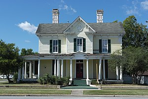
Baptist Parsonage
Historic house in North Carolina, United States
Distance: Approx. 567 meters
Latitude and longitude: 35.25777778,-77.58
Baptist Parsonage, also known as Archbell House, is a historic Baptist church parsonage located at 211 S. McLewean Street in Kinston, Lenoir County, North Carolina. It was built about 1858, and is a two-story, double-pile, center-hall-plan Greek Revival style frame dwelling. It is sheathed with weatherboard siding, has a hipped roof, and paired stuccoed interior chimneys.

Harmony Hall (Kinston, North Carolina)
United States national historic site
Distance: Approx. 415 meters
Latitude and longitude: 35.25916667,-77.58305556
Harmony Hall, also known as the Peebles House, is a historic building located at 109 East King Street in Kinston, North Carolina, United States. The 18th-century house, the oldest building in Kinston, was owned by North Carolina's first elected governor. The house briefly served as the de facto state capitol during the Revolutionary War.
B. W. Canady House
Historic house in North Carolina, United States
Distance: Approx. 411 meters
Latitude and longitude: 35.26638889,-77.58166667
B. W. Canady House is a historic home located at Kinston, Lenoir County, North Carolina. It was built about 1883, and is a two-story, L-shaped, Italianate style frame dwelling. It has a gable roof, gabled two-story projecting central entrance bay, and one-story rear wing.
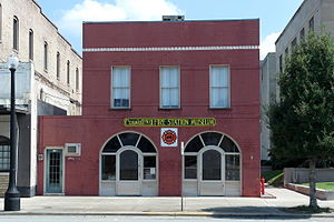
Kinston Fire Station-City Hall
United States historic place
Distance: Approx. 363 meters
Latitude and longitude: 35.25944444,-77.58138889
Kinston Fire Station-City Hall is a historic fire station and city hall located at Kinston, Lenoir County, North Carolina. It was built in 1895, and is a two-story brick structure with a two-story rear wing built in several stages. The main block has a sloping roof with raised parapet.
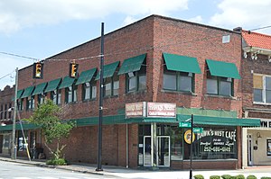
Sumrell and McCoy Building
United States historic place
Distance: Approx. 102 meters
Latitude and longitude: 35.26361111,-77.58166667
Sumrell and McCoy Building is a historic commercial / industrial building located at Kinston, Lenoir County, North Carolina, built in 1910. It is a two-story and basement brick structure of heavy post and beam construction, using both wood and steel members. It has a raised parapet, topped by tile coping.

Hotel Kinston
United States historic place
Distance: Approx. 260 meters
Latitude and longitude: 35.265,-77.58111111
Hotel Kinston is an historic hotel building located at Kinston, Lenoir County, North Carolina. It was built in 1927–1928, and is an 11-story, steel frame Art Deco style building. It is sheathed in red brick with cast stone Moorish stylistic details at the main entrance and top floors.
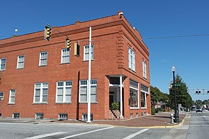
Peoples Bank Building
United States historic place
Distance: Approx. 565 meters
Latitude and longitude: 35.25763889,-77.58111111
Peoples Bank Building is a historic bank building located at Kinston, Lenoir County, North Carolina. It was built about 1923, and is a modest two-story, cinder block building, sheathed in brick and in the Classical Revival style. It has a flat roof with raised parapet ornamented by brick panels outlined in limestone.

Atlantic and North Carolina Railroad Freight Depot
United States historic place
Distance: Approx. 127 meters
Latitude and longitude: 35.26305556,-77.58027778
Atlantic and North Carolina Railroad Freight Depot was a historic freight depot located at Kinston, Lenoir County, North Carolina. It was built in 1900 by the Atlantic and North Carolina Railroad, and is a two-story Romanesque style building faced in tan brick. It had a standing seam tin gable roof with a monitor roof and 11 freight bays.

Queen–Gordon Streets Historic District
Historic district in North Carolina, United States
Distance: Approx. 95 meters
Latitude and longitude: 35.26194444,-77.58111111
Queen–Gordon Streets Historic District is a national historic district located at Kinston, Lenoir County, North Carolina. It encompasses 20 contributing buildings in a mixed commercial and industrial section of Kinston. The buildings include notable examples of Classical Revival, Beaux-Arts, and Romanesque style architecture and date between 1895 and the mid-1930s.
Kinston Commercial Historic District
Historic district in North Carolina, United States
Distance: Approx. 95 meters
Latitude and longitude: 35.26277778,-77.58055556
Kinston Commercial Historic District is a national historic district located at Kinston, Lenoir County, North Carolina. It encompasses 30 contributing buildings in a mixed commercial and industrial section of Kinston. The district is considered a boundary increase to the previously listed Queen-Gordon Streets Historic District.
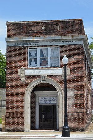
Standard Drug No. 2
United States historic place
Distance: Approx. 304 meters
Latitude and longitude: 35.26,-77.58111111
The Standard Drug No. 2 is a historic commercial building located in Kinston, Lenoir County, North Carolina. It was built between 1918 and 1924, and is a two-story, brick Commercial Style with street level, plate-glass windows.
Weather in this IP's area
scattered clouds
28 Celsius
29 Celsius
27 Celsius
28 Celsius
1018 hPa
57 %
1018 hPa
1017 hPa
10000 meters
2.06 m/s
140 degree
40 %
07:08:30
18:48:25