Country:
 USA
USARegion:
City:
Latitude and Longitude:
Time Zone:
Postal Code:
IP information under different IP Channel
ip-api
Country
Region
City
ASN
Time Zone
ISP
Blacklist
Proxy
Latitude
Longitude
Postal
Route
IPinfo
Country
Region
City
ASN
Time Zone
ISP
Blacklist
Proxy
Latitude
Longitude
Postal
Route
MaxMind
Country
Region
City
ASN
Time Zone
ISP
Blacklist
Proxy
Latitude
Longitude
Postal
Route
Luminati
Country
USRegion
tx
City
houston
ASN
Time Zone
America/Chicago
ISP
TEXASNET-ASN
Latitude
Longitude
Postal
db-ip
Country
Region
City
ASN
Time Zone
ISP
Blacklist
Proxy
Latitude
Longitude
Postal
Route
ipdata
Country
Region
City
ASN
Time Zone
ISP
Blacklist
Proxy
Latitude
Longitude
Postal
Route
Popular places and events near this IP address
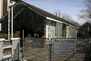
Rice Military, Houston
Distance: Approx. 1227 meters
Latitude and longitude: 29.767,-95.416
Rice Military is a neighborhood in Houston, Texas, United States. The Beer Can House is located in Rice Military.

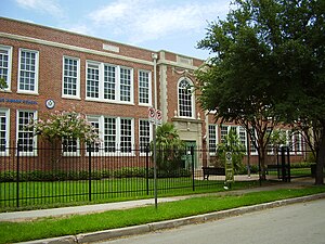
St. Thomas High School (Houston)
Private boys secondary school in Houston, Texas, United States
Distance: Approx. 1304 meters
Latitude and longitude: 29.76222222,-95.40805556
St. Thomas High School is an all-boys, Catholic college preparatory school in Houston, Texas. Founded in 1900, St.

Olivewood Cemetery
Cemetery in Houston, Texas
Distance: Approx. 1353 meters
Latitude and longitude: 29.774,-95.392
Olivewood Cemetery, in Houston, Texas, lies near a bend in White Oak Bayou, along the rail line to Chaney Junction, where the First and Sixth wards meet just northwest of downtown. The 6-acre (24,000 m2) cemetery is an historic resting place for many freed slaves and some of Houston's earliest black residents.

Star Engraving Company Building
United States historic place
Distance: Approx. 1644 meters
Latitude and longitude: 29.76027778,-95.39916667
The Star Engraving Company Building is a building at 3201 Allen Parkway in Houston, Texas, built in 1930 in the Spanish Colonial Revival style by the Star Engraving company to house its engraving factory. The building is currently (as of 2013) owned by the city of Houston and serves as the Houston Center for the Arts, housing the Stages Repertory Theatre, the Houston Arts Alliance, and the Bayou Preservation Alliance.

American General Center
Office complex in Houston, Texas
Distance: Approx. 1667 meters
Latitude and longitude: 29.760745,-95.39754867
The American General Center is a complex of several office buildings in Neartown Houston, Texas located along Allen Parkway. It is the global headquarters for Corebridge Financial, formerly American General. The America Tower is a 590 ft (180m) tall skyscraper.
Harvard Elementary School (Texas)
Public primary school in Houston, Texas
Distance: Approx. 1690 meters
Latitude and longitude: 29.7862,-95.3959
Harvard Elementary School is a public primary school in the Houston Heights neighborhood of Houston, Texas, United States. Harvard, a part of the Houston Independent School District, serves grades Pre-Kindergarten through 5. Harvard Elementary School, in Houston Heights block 248, serves a section of that community.
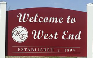
West End (Houston)
Neighborhood in Houston, Texas
Distance: Approx. 213 meters
Latitude and longitude: 29.773,-95.404
West End is a neighborhood in Houston, Texas, United States located along the Washington Avenue Corridor. The West End was traditionally a working-class neighborhood that was established in the early 1920s in Houston Texas. Recent gentrification has increased the population density and the development of numerous townhome communities has grown and businesses that cater to the demographic have increased.
Brunner, Houston
Distance: Approx. 213 meters
Latitude and longitude: 29.773,-95.408
Brunner is an area within Houston that was at one time a distinct community. Brunner was in west central Harris County, along the Houston and Texas Central Railway and 3 miles (4.8 km) west of Houston. In 1895 Brunner's population was 500, and it had two churches, a Baptist college, a public school, a saloon, and a German school.

John W. Anderson House
Historic house in Texas, United States
Distance: Approx. 1681 meters
Latitude and longitude: 29.78361111,-95.39277778
The John W. Anderson House is a house located in Houston, Texas listed on the National Register of Historic Places. Built in 1907, the house is classified as a Queen Anne style cottage.

Isbell House
Historic house in Texas, United States
Distance: Approx. 1229 meters
Latitude and longitude: 29.78222222,-95.39777778
The Isbell House, located at 639 Heights Boulevard in Houston, Texas, was listed on the National Register of Historic Places on June 22, 1983. It is one of 104 structures nominated to the Register in 1983 as part of the Houston Heights Multiple Resource Area in the Houston Heights neighborhood.

Morton Brothers Grocery
United States historic place
Distance: Approx. 1538 meters
Latitude and longitude: 29.78694444,-95.40111111
The Morton Brothers Grocery, located at 401 West Ninth in Houston, Texas, is a historic building located in the Houston Heights neighborhood. Built in 1929, it was a neighborhood grocery store run by Curtis Ira Morton (born 22 Jan 1866 in Tippecanoe, Indiana, USA) and his brother, William J. Morton until 1949. During a break-in and robbery, Curtis Morton was mortally wounded and died in 1949.
Rockefeller's
Distance: Approx. 998 meters
Latitude and longitude: 29.76972222,-95.39680556
Rockefeller's is a live music venue located in Houston, Texas.
Weather in this IP's area
broken clouds
29 Celsius
34 Celsius
28 Celsius
31 Celsius
1014 hPa
70 %
1014 hPa
1012 hPa
10000 meters
4.63 m/s
70 degree
75 %
07:17:22
19:02:07