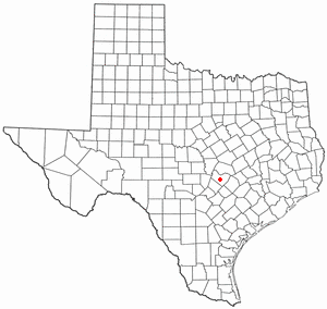
Country:
 USA
USARegion:
City:
Latitude and Longitude:
Time Zone:
Postal Code:
IP information under different IP Channel
ip-api
Country
Region
City
ASN
Time Zone
ISP
Blacklist
Proxy
Latitude
Longitude
Postal
Route
IPinfo
Country
Region
City
ASN
Time Zone
ISP
Blacklist
Proxy
Latitude
Longitude
Postal
Route
MaxMind
Country
Region
City
ASN
Time Zone
ISP
Blacklist
Proxy
Latitude
Longitude
Postal
Route
Luminati
Country
USASN
Time Zone
America/Chicago
ISP
TEXASNET-ASN
Latitude
Longitude
Postal
db-ip
Country
Region
City
ASN
Time Zone
ISP
Blacklist
Proxy
Latitude
Longitude
Postal
Route
ipdata
Country
Region
City
ASN
Time Zone
ISP
Blacklist
Proxy
Latitude
Longitude
Postal
Route
Popular places and events near this IP address
Rollingwood, Texas
City in Texas, United States
Distance: Approx. 789 meters
Latitude and longitude: 30.27361111,-97.78694444
Rollingwood is a city in Travis County, Texas, United States. Part of the Austin–Round Rock metropolitan area, the population was 1,467 at the 2020 census.
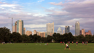
Zilker Park
Historic urban park in Austin, Texas
Distance: Approx. 1327 meters
Latitude and longitude: 30.26361111,-97.77666667
Zilker Metropolitan Park is a recreational area in south Austin, Texas at the juncture of Barton Creek and the Colorado River that comprises over 350 acres (142 ha) of publicly owned land. It is named after its benefactor, Andrew Jackson Zilker, who donated the land to the city in 1917. The land was developed into a park during the Great Depression in the 1930s.
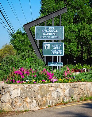
Zilker Botanical Garden
Botanical garden in Austin, Texas, U.S.
Distance: Approx. 1791 meters
Latitude and longitude: 30.2689,-97.7714
The Zilker Botanical Garden (31 acres; 125,000 m2) is a botanical garden of varied topography located on the south bank of the Colorado River at 2220 Barton Springs Road, near downtown Austin, Texas, United States. Theme gardens include the Taniguchi Japanese Garden, The Riparian Streambed, The Hartman Prehistoric Garden, and The Mabel Davis Rose Garden. The Botanical Garden was established as a non-profit organization in 1955, and is the centerpiece of Zilker Park.
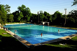
Deep Eddy Pool
Historic public pool in Austin, Texas
Distance: Approx. 1927 meters
Latitude and longitude: 30.27638889,-97.77305556
Deep Eddy Pool is a historic man-made swimming pool in Austin, Texas. Deep Eddy is the oldest swimming pool in Texas and features a bathhouse built during the Depression era by the Works Progress Administration. The pool began as a swimming hole in the Colorado River, became a resort in the 1920s, and is today a popular swimming pool operated by the City of Austin.
Hartman Prehistoric Garden
Botanical garden
Distance: Approx. 1774 meters
Latitude and longitude: 30.2701,-97.7718
The Hartman Prehistoric Garden is a botanical garden within the Zilker Botanical Garden in Austin, Texas, USA. In January 1992 Karen and Dr. Mike Duffin discovered dinosaur footprints in Zilker Park in an old limestone quarry which had recently been cleared for the installation of a butterfly garden. Dr.

Old West Austin Historic District
Historic district in Texas, United States
Distance: Approx. 1327 meters
Latitude and longitude: 30.26361111,-97.77666667
The Old West Austin Historic District is a residential community in Austin, Texas, United States. It is composed of three neighborhoods located on a plateau just west of downtown Austin: Old Enfield, Pemberton Heights, and Bryker Woods. Developed between 1886 and 1953, the three historic neighborhoods stretch from Mopac Expressway east to Lamar Boulevard, and from 13th Street north to 35th Street.

Barton Creek Square
Shopping mall in Texas, United States
Distance: Approx. 1933 meters
Latitude and longitude: 30.2576,-97.8068
Barton Creek Square is an enclosed shopping mall located in southwest Austin, Texas in the United States, near the intersection of Texas State Highway Loop 1 and Texas State Highway Loop 360. The mall is eponymously named after Barton Creek, Texas. Anchor stores are Dillard's, JCPenney, Macy's, and Nordstrom.

Barton Hills, Austin, Texas
Distance: Approx. 1306 meters
Latitude and longitude: 30.25805556,-97.78111111
Barton Hills is a neighborhood in Austin, Texas. It is located in south Austin, and encompasses part of ZIP code 78704. Barton Hills is bounded by South Lamar and Zilker neighborhoods to the east, Barton Springs Road and Zilker Park to the north, Barton Creek and the Spyglass-Barton's Bluff neighborhood to the west and the Capital of Texas Highway to the south.

West Line Historic District (Austin, Texas)
Historic district in Texas, United States
Distance: Approx. 1327 meters
Latitude and longitude: 30.26361111,-97.77666667
The West Line Historic District is a residential community in central Austin, Texas, United States. The district encompasses an approximately 90-block tract of land located west of downtown. Bounded by Baylor Street to the east, Fifth Street to the south, Thirteenth Street to the north and Texas State Highway Loop 1 to the west.
Spyglass-Barton's Bluff, Austin, Texas
Distance: Approx. 985 meters
Latitude and longitude: 30.25816032,-97.78950232
Spyglass-Barton's Bluff is a neighborhood in Austin, Texas. It is located southwest of the city's urban core, and encompasses ZIP codes 78746 and 78704. Sometimes known as Barton's Bluff-Spyglass, the neighborhood is a narrow strip of land that runs between Mopac Expressway and Barton Creek in northwest Austin.
South River City, Austin, Texas
Distance: Approx. 1306 meters
Latitude and longitude: 30.25805556,-97.78111111
South River City is a community located in Austin, Texas. Also frequently called Travis Heights, the neighborhood is located south of the city's urban core, just below Lake Lady Bird in South Austin. The area encompasses a portion of ZIP code 78704.
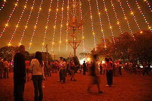
Zilker Holiday Tree
Christmas decoration in Austin, Texas
Distance: Approx. 1800 meters
Latitude and longitude: 30.26638889,-97.77119444
The Zilker Holiday Tree is a 155 foot Christmas tree made from lights draped from a moonlight tower located in Zilker Park (Austin, Texas). During the Christmas season the tree is lit by over 3000 colored lights. The lighting of the tree has been an annual tradition in Austin since 1967.
Weather in this IP's area
few clouds
33 Celsius
35 Celsius
32 Celsius
35 Celsius
1014 hPa
45 %
1014 hPa
993 hPa
10000 meters
3.09 m/s
80 degree
20 %
07:27:07
19:11:26