209.53.209.176 - IP Lookup: Free IP Address Lookup, Postal Code Lookup, IP Location Lookup, IP ASN, Public IP
Country:
 Canada
Region:
City:
Location:
Time Zone:
Postal Code:
ISP:
ASN:
language:
User-Agent:
Proxy IP:
Blacklist:
IP information under different IP Channel
ip-api
Country
Region
City
ASN
Time Zone
ISP
Blacklist
Proxy
Latitude
Longitude
Postal
Route
db-ip
Country
Region
City
ASN
Time Zone
ISP
Blacklist
Proxy
Latitude
Longitude
Postal
Route
IPinfo
Country
Region
City
ASN
Time Zone
ISP
Blacklist
Proxy
Latitude
Longitude
Postal
Route
IP2Location
209.53.209.176Country
caRegion
british columbia
City
richmond
Time Zone
America/Vancouver
ISP
Language
User-Agent
Latitude
Longitude
Postal
ipdata
Country
Region
City
ASN
Time Zone
ISP
Blacklist
Proxy
Latitude
Longitude
Postal
Route
Popular places and events near this IP address

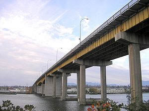
Knight Street Bridge
Bridge in Richmond, Vancouver
Distance: Approx. 1886 meters
Latitude and longitude: 49.204084,-123.077517
The Knight Street Bridge is a crossing over the north arm of the Fraser River, the Canadian National Railway (CNR) line, and several roads, in Metro Vancouver.
Oak Street Bridge
Bridge in Vancouver-Richmond
Distance: Approx. 2004 meters
Latitude and longitude: 49.19972222,-123.12555556
The Oak Street Bridge is a crossing over the north arm of the Fraser River, the Canada Line, and several roads, in Metro Vancouver.

Mitchell Island
Island in the North Arm of the Fraser River in British Columbia, Canada
Distance: Approx. 1012 meters
Latitude and longitude: 49.2025,-123.09194444
Mitchell Island is an island in the North Arm of the Fraser River in British Columbia, Canada, located between the cities of Vancouver and Richmond (incorporated as part of the latter). It is crossed by (and has on- and off-ramps for) the Knight Street Bridge, which is one of the main bridges between the City of Vancouver and Richmond. Originally agricultural, its land is now mainly used for industrial purposes.
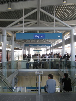
Bridgeport station (SkyTrain)
Metro Vancouver SkyTrain station
Distance: Approx. 1967 meters
Latitude and longitude: 49.19555556,-123.12611111
Bridgeport is an elevated station on the Canada Line of Metro Vancouver's SkyTrain rapid transit system. It is located in Richmond, British Columbia, Canada, south of Vancouver. The Canada Line branches outbound at this station, with one branch heading westward to YVR–Airport station at the Vancouver International Airport and the other heading south to Richmond–Brighouse station in the commercial centre of Richmond.

Marine Drive station
Metro Vancouver SkyTrain station
Distance: Approx. 2117 meters
Latitude and longitude: 49.20972222,-123.11694444
Marine Drive is an elevated station on the Canada Line of Metro Vancouver's SkyTrain rapid transit system. The station is located at the intersection of Cambie Street and SW Marine Drive in Vancouver, British Columbia.

River Rock Casino Resort
Casino in British Columbia, Canada
Distance: Approx. 2120 meters
Latitude and longitude: 49.196257,-123.128141
River Rock Casino Resort in Richmond, British Columbia is the largest casino in the province of British Columbia. The casino is owned by Great Canadian Entertainment. The hotel has a total of 396 rooms, including standard rooms and suites and it is situated on the river with a 144-berth marina.

Henry James Cambie Secondary School
High school in Richmond, British Columbia, Canada
Distance: Approx. 1792 meters
Latitude and longitude: 49.1834,-123.08155
Henry James Cambie Secondary School is a public high school in Richmond, British Columbia, part of School District 38 Richmond.

Marpole Bridge
Bridge in Marpole–Richmond
Distance: Approx. 2066 meters
Latitude and longitude: 49.19916667,-123.12666667
The Marpole CP Rail Bridge was a partially dismantled crossing over the north arm of the Fraser River, and River Dr., in Metro Vancouver.

North Arm Bridge
Bridge in Metro Vancouver, British Columbia, Canada
Distance: Approx. 1596 meters
Latitude and longitude: 49.20222222,-123.11777778
The North Arm Bridge is an extradosed bridge in Metro Vancouver, British Columbia, Canada. It spans the north arm of the Fraser River, linking Vancouver to Richmond. It is used by trains on the Canada Line, which opened in August 2009.

Sato Pharmaceutical
Japanese pharmaceutical company
Distance: Approx. 1059 meters
Latitude and longitude: 49.186805,-123.107211
Sato Pharmaceutical Co., Ltd. (佐藤製薬株式会社, Satō Seiyaku Kabushiki-gaisha) is a Japanese pharmaceutical company. Sato Pharmaceutical's main focus is on over-the-counter medicines.
Bridgeport, British Columbia
Neighbourhood
Distance: Approx. 1319 meters
Latitude and longitude: 49.199,-123.116
Bridgeport is a mostly industrial neighborhood in Richmond, British Columbia. It holds Bridgeport station at the west side of the neighbourhood, which is a stop on the Canada Line of the Vancouver SkyTrain System. Its population is 3,897 as of 2020.

Fraser Street Bridge (1894)
Bridge in Sunset-Richmond
Distance: Approx. 691 meters
Latitude and longitude: 49.19805556,-123.09111111
The Fraser St. Bridge (1894–1974), also known as the Fraser Ave. Bridge, North Arm Bridge, No.
Weather in this IP's area
scattered clouds
1 Celsius
-3 Celsius
-0 Celsius
2 Celsius
1021 hPa
66 %
1021 hPa
1021 hPa
10000 meters
3.6 m/s
100 degree
40 %