Country:
 USA
USARegion:
City:
Latitude and Longitude:
Time Zone:
Postal Code:
IP information under different IP Channel
ip-api
Country
Region
City
ASN
Time Zone
ISP
Blacklist
Proxy
Latitude
Longitude
Postal
Route
IPinfo
Country
Region
City
ASN
Time Zone
ISP
Blacklist
Proxy
Latitude
Longitude
Postal
Route
MaxMind
Country
Region
City
ASN
Time Zone
ISP
Blacklist
Proxy
Latitude
Longitude
Postal
Route
Luminati
Country
USASN
Time Zone
America/Chicago
ISP
UNITAS
Latitude
Longitude
Postal
db-ip
Country
Region
City
ASN
Time Zone
ISP
Blacklist
Proxy
Latitude
Longitude
Postal
Route
ipdata
Country
Region
City
ASN
Time Zone
ISP
Blacklist
Proxy
Latitude
Longitude
Postal
Route
Popular places and events near this IP address

Goleta, California
City in California, United States
Distance: Approx. 1423 meters
Latitude and longitude: 34.44055556,-119.81361111
Goleta (; Spanish: [ɡoˈleta]; Spanish for "schooner") is a city in southern Santa Barbara County, California, United States. It was incorporated as a city in 2002, after a long period as the largest unincorporated populated area in the county. As of the 2000 census, the census-designated place (CDP) had a total population of 55,204.

Santa Barbara Municipal Airport
Municipal airport in Goleta, California, United States
Distance: Approx. 1560 meters
Latitude and longitude: 34.42611111,-119.84027778
Santa Barbara Municipal Airport (IATA: SBA, ICAO: KSBA, FAA LID: SBA) is 7 miles (6 nmi; 11 km) west of downtown Santa Barbara, California, United States. The airfield covers 948 acres (384 ha) of land and has three runways. It is near the University of California, Santa Barbara, and the city of Goleta.

Direct Relief
Charitable organization
Distance: Approx. 1407 meters
Latitude and longitude: 34.43734,-119.8432121
Direct Relief (formerly known as Direct Relief International) is a nonprofit humanitarian organization whose mission is to improve the lives of people in poverty or emergency situations by providing the appropriate medical resources. The charity provides emergency medical assistance and disaster relief in the United States and internationally. The organization is headed by an independent board of directors and its president and CEO, Thomas Tighe.

Goleta station
Railway station in Goleta, California, US
Distance: Approx. 1402 meters
Latitude and longitude: 34.4377,-119.8431
Goleta station is a passenger rail station in the city of Goleta, California. It is served by the Amtrak Pacific Surfliner; it is the northern terminal for three of those round trips. Trains terminating in Goleta are stored on a storage track adjacent to the station.

Goleta Valley Junior High School
Public school in the United States
Distance: Approx. 1755 meters
Latitude and longitude: 34.45055556,-119.83472222
Goleta Valley Junior High School is a public junior high school in Goleta, California, just northwest of Santa Barbara, California. It serves a student body of approximately 785 students in 7-8 grades, and employs roughly fifty-five teachers as part of the Santa Barbara School Districts. Goleta Valley Junior High School ("GVJH" or simply "GV") is a National Blue Ribbon School.

Atascadero Creek (Santa Barbara County, California)
River in California, United States
Distance: Approx. 1793 meters
Latitude and longitude: 34.41972222,-119.82916667
Atascadero Creek is a southwest flowing stream in Santa Barbara County, California, United States which empties into the Goleta Slough.
Rancho La Goleta
Land grant in California
Distance: Approx. 1717 meters
Latitude and longitude: 34.44,-119.81
Rancho La Goleta was a 4,426-acre (17.91 km2) Mexican land grant in present-day Santa Barbara County, California given in 1846 by Governor Pío Pico to Daniel A. Hill. The grant extended along the Pacific coast from today’s Fairview Avenue in present-day Goleta, east to Hope Ranch. The grant was adjacent to Rancho Dos Pueblos granted to his son-in-law Nicolas A. Den in 1842.
Mescalitan Island
Island in California
Distance: Approx. 1652 meters
Latitude and longitude: 34.42166,-119.83347
Mescalitan Island is a mesalike island located about 10 miles (16 km) west of Santa Barbara near the outlet of the Goleta Slough into the Pacific Ocean.

Joseph and Lucy Foster Sexton House
Historic house in California, United States
Distance: Approx. 1168 meters
Latitude and longitude: 34.43583333,-119.81527778
The Sexton House in Goleta, California is a two-story Italianate style house that was built in 1880. It was designed by architect Peter J. Barber. It was listed on the U.S. National Register of Historic Places (NRHP) in 1992 as 'Joseph and Lucy Foster Sexton House.
La Patera, California
Unincorporated community in California, United States
Distance: Approx. 1319 meters
Latitude and longitude: 34.4375,-119.84222222
La Patera (Spanish for "The Place of Ducks") was a historical locale in what is now the area of Goleta, California. Prior to European settlement, the area was inhabited by the Chumash, who had a settlement in the area named Saspilil. The Portolá expedition reached the area in August 1769 and gave it the name Laguna, but this was later changed to La Patera owing to the abundant ducks inhabiting the area's wetlands.
Goleta Cultural School
Distance: Approx. 89 meters
Latitude and longitude: 34.435,-119.828
The Cultural School of Goleta is a multi-purpose venue built by Ken and Miye Ota. The facility consists of a large ballroom with a sprung hardwood floor, two crystal chandeliers, a raised stage and is surrounded by built-in benches for seating. There is also an attached industrial kitchen, audio system, changing room, and storage for the additional chairs and tables.
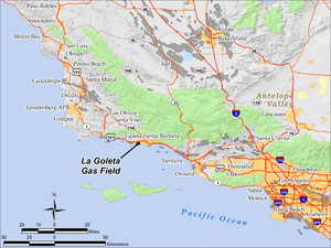
La Goleta Gas Field
Natural gas field in Santa Barbara County, California, United States
Distance: Approx. 1782 meters
Latitude and longitude: 34.4218,-119.8186
The La Goleta Gas Field (also known as the Goleta Gas Field and La Goleta Storage Field) is a natural gas field in unincorporated Santa Barbara County, California, adjacent to the city of Goleta. Discovered in 1929, and first put into production in 1932, it has been in continuous use ever since, producing approximately 12 billion cubic feet of gas. With production declining, the field was converted into a gas storage reservoir in 1941.
Weather in this IP's area
clear sky
19 Celsius
19 Celsius
17 Celsius
31 Celsius
1008 hPa
72 %
1008 hPa
1007 hPa
10000 meters
2.68 m/s
3.58 m/s
06:38:01
19:15:53