Country:
 USA
USARegion:
City:
Latitude and Longitude:
Time Zone:
Postal Code:
IP information under different IP Channel
ip-api
Country
Region
City
ASN
Time Zone
ISP
Blacklist
Proxy
Latitude
Longitude
Postal
Route
IPinfo
Country
Region
City
ASN
Time Zone
ISP
Blacklist
Proxy
Latitude
Longitude
Postal
Route
MaxMind
Country
Region
City
ASN
Time Zone
ISP
Blacklist
Proxy
Latitude
Longitude
Postal
Route
Luminati
Country
USRegion
ia
City
cedarrapids
ASN
Time Zone
America/Chicago
ISP
IMONC
Latitude
Longitude
Postal
db-ip
Country
Region
City
ASN
Time Zone
ISP
Blacklist
Proxy
Latitude
Longitude
Postal
Route
ipdata
Country
Region
City
ASN
Time Zone
ISP
Blacklist
Proxy
Latitude
Longitude
Postal
Route
Popular places and events near this IP address

USS Halsey Powell
Fletcher-class destroyer
Distance: Approx. 2037 meters
Latitude and longitude: 41.967025,-91.687683
USS Halsey Powell (DD-686), was a Fletcher-class destroyer of the United States Navy.
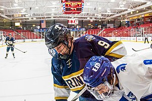
ImOn Ice Arena
Multipurpose arena in Cedar Rapids, Iowa, United States
Distance: Approx. 2053 meters
Latitude and longitude: 41.96583,-91.688559
The ImOn Ice Arena is a 3,850-seat multipurpose arena in Cedar Rapids, Iowa, located adjacent to Veterans Memorial Stadium. The arena opened on January 8, 2000, and is owned by the city of Cedar Rapids. It is home to the Cedar Rapids RoughRiders of the United States Hockey League as well as several local youth hockey teams.

Veterans Memorial Stadium (Cedar Rapids)
Distance: Approx. 2071 meters
Latitude and longitude: 41.96805556,-91.68638889
Veterans Memorial Stadium is a minor league baseball stadium in Cedar Rapids, Iowa. It is the home field of the Cedar Rapids Kernels of the Midwest League. It is often called New Veterans Memorial Stadium to distinguish it from the original Veterans Memorial Stadium, which existed from 1949 to 2001.
Jefferson High School (Iowa)
Public secondary school in Cedar Rapids, Iowa, United States
Distance: Approx. 1577 meters
Latitude and longitude: 41.965,-91.69805556
Thomas Jefferson High School is a public high school in Cedar Rapids, Iowa. It is the eighth largest high school in Iowa. The school's mascot is Jeffy the J-Hawk and the official school colors are Columbia Blue and white.

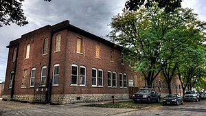
Mother Mosque of America
Historic mosque in Iowa, United States
Distance: Approx. 2278 meters
Latitude and longitude: 41.98630278,-91.68394444
The Mother Mosque of America, once known as The Rose of Fraternity Lodge, in Cedar Rapids, Iowa, United States, is the oldest standing purpose-built mosque in the United States, having been completed in 1934. The Al-Sadiq Mosque in Chicago and the Powers Street Mosque are older by a decade but were converted from existing buildings to be used as a Muslim house of worship. An older purpose-built mosque is the Highland Park Mosque, built in 1921 to serve immigrant workers in the Detroit Metro Area, which was sold in 1926.

Lustron Home No. 02102
Historic house in Iowa, United States
Distance: Approx. 921 meters
Latitude and longitude: 41.97083333,-91.70083333
The Lustron Home No. 02102 is a historic enameled steel prefabricated Lustron house located in Cedar Rapids, Iowa. It was listed on the National Register of Historic Places in 2004.

Cedar Rapids Community School District
School district in Cedar Rapids, Iowa, United States
Distance: Approx. 1733 meters
Latitude and longitude: 41.968597,-91.690694
The Cedar Rapids Community School District (CRCSD) is a public school district located in Cedar Rapids, Iowa. It has the second largest enrollment in the state of Iowa. The district has 21 elementary schools, 6 middle schools, 4 high schools, and 1 alternative high school.

Philip A. Wolff House and Carriage House
Historic house in Iowa, United States
Distance: Approx. 1418 meters
Latitude and longitude: 41.98072222,-91.69205556
The Philip A. Wolff House and Carriage House, also known as Belmont Hill, is a historic building located in Cedar Rapids, Iowa, United States. An Ohio native, Wolff lived in several states and the West Indies before settling in Maquoketa, Iowa. He moved to Cedar Rapids where he established a brickworks with his son.
Cedar Rapids Pump Company Factory and Warehouse
United States historic place
Distance: Approx. 2294 meters
Latitude and longitude: 41.97988889,-91.68097222
The Cedar Rapids Pump Company Factory and Warehouse are two historic buildings located in Cedar Rapids, Iowa, United States. The company began in 1881. They manufactured and distributed water pumps and windmills throughout the Midwest from this facility from 1884 to 1929.

St. James United Methodist Church (Cedar Rapids, Iowa)
United States historic place
Distance: Approx. 2442 meters
Latitude and longitude: 41.98744444,-91.68252778
Trinity-St. James United Methodist Church is located in Cedar Rapids, Iowa, United States. The congregation began as a Sunday school in the northwest part of the city organized by Trinity Methodist Episcopal Church.
Kingston Stadium
Distance: Approx. 1846 meters
Latitude and longitude: 41.96741111,-91.69011389
Kingston Stadium is a football stadium in Cedar Rapids, Iowa. Kingston Stadium is located southwest of downtown Cedar Rapids, adjacent to Veterans Memorial Stadium and ImOn Ice Arena. Opened September 12, 1952, it was named for a settlement called Kingston established in 1839 on the west side of the Cedar River which was later annexed into Cedar Rapids.

Shores-Mueller Company
United States historic place
Distance: Approx. 2294 meters
Latitude and longitude: 41.97988889,-91.68097222
The Shores-Mueller Company is a historic building located in Cedar Rapids, Iowa, United States. The original section of the building was completed in 1911. Its construction utilized the Turner Cap system, which is a concrete flat-slab support system.
Weather in this IP's area
clear sky
20 Celsius
21 Celsius
18 Celsius
22 Celsius
1014 hPa
77 %
1014 hPa
987 hPa
10000 meters
2.06 m/s
120 degree
06:43:26
19:23:26