Country:
 USA
USARegion:
City:
Latitude and Longitude:
Time Zone:
Postal Code:
IP information under different IP Channel
ip-api
Country
Region
City
ASN
Time Zone
ISP
Blacklist
Proxy
Latitude
Longitude
Postal
Route
IPinfo
Country
Region
City
ASN
Time Zone
ISP
Blacklist
Proxy
Latitude
Longitude
Postal
Route
MaxMind
Country
Region
City
ASN
Time Zone
ISP
Blacklist
Proxy
Latitude
Longitude
Postal
Route
Luminati
Country
USASN
Time Zone
America/Chicago
ISP
SYSSRC
Latitude
Longitude
Postal
db-ip
Country
Region
City
ASN
Time Zone
ISP
Blacklist
Proxy
Latitude
Longitude
Postal
Route
ipdata
Country
Region
City
ASN
Time Zone
ISP
Blacklist
Proxy
Latitude
Longitude
Postal
Route
Popular places and events near this IP address
WZBA
Radio station in Maryland, United States
Distance: Approx. 761 meters
Latitude and longitude: 39.44733333,-76.77969444
WZBA (100.7 FM, "100.7 The Bay") is a commercial FM radio station licensed to serve Westminster, Maryland. The station is owned by Times-Shamrock Communications and broadcasts a classic rock format. Its studios are in Hunt Valley and its broadcast tower is located near Owings Mills at (39°26′49.9″N 76°46′47.2″W).

Rosewood Center
Hospital in Maryland, United States
Distance: Approx. 1990 meters
Latitude and longitude: 39.42361111,-76.77083333
The Rosewood Center was an institution for people with developmental disabilities located on Rosewood Lane in Owings Mills, Maryland. It was established in 1888 as the Asylum and Training School for the Feeble-Minded. From 1912 to 1961, it was known as the Rosewood State Training School.
WCAO
Radio station in Baltimore, Maryland
Distance: Approx. 1794 meters
Latitude and longitude: 39.42972222,-76.76166667
WCAO (600 AM "Heaven 600") is a commercial radio station in Baltimore, Maryland. It broadcasts an urban gospel radio format and is owned by iHeartMedia, Inc. It also airs some Christian talk and teaching programs.

Owings Mills High School
Public secondary school in Owings Mills, Maryland, United States
Distance: Approx. 2519 meters
Latitude and longitude: 39.42305556,-76.79472222
Owings Mills High School (OMHS) is a four-year public high school in Owings Mills, Maryland, United States. It is part of the Baltimore County Public Schools consolidated school district.
Caves Valley Golf Club
Non-profit golf club in Maryland, US
Distance: Approx. 3028 meters
Latitude and longitude: 39.451,-76.744
Caves Valley Golf Club is a member-owned not-for-profit corporation in Owings Mills, Maryland, a suburb northwest of Baltimore. The golf course opened 33 years ago in 1991, and is known for its fast greens, rolling fairways, and water hazards; it was rated as 47th among America's best modern courses by Golfweek magazine in 1997.
Gwynnbrook Wildlife Management Area
Wildlife Management Area
Distance: Approx. 618 meters
Latitude and longitude: 39.44638889,-76.77777778
Gwynnbrook Wildlife Management Area is an 88-acre (36 ha) Wildlife Management Area in Owings Mills, Baltimore County, Maryland. The property is a former game farm that was purchased by Maryland in 1919, and is the oldest WMA in the state.

St. Thomas Church (Owings Mills, Maryland)
Historic church in Maryland, United States
Distance: Approx. 2462 meters
Latitude and longitude: 39.42194444,-76.76194444
St. Thomas' Episcopal Church is a parish of the Episcopal Church in Owings Mills, Baltimore County, Maryland, part of the Diocese of Maryland. It is noted for its historic parish church, built in 1743.
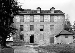
Owings Upper Mill
United States historic place
Distance: Approx. 2182 meters
Latitude and longitude: 39.421936,-76.78314
The Owings Upper Mill (also known as A.E. Groff's Flour Mill) is a historic grist mill located at Owings Mills, Baltimore County, Maryland, United States. It is a large 3+1⁄2-story brick structure, 50 by 60 feet (15 by 18 m). The building stands on a low stone foundation, surmounted by a molded brick water table.
Caves Valley Historic District
Historic district in Maryland, United States
Distance: Approx. 2464 meters
Latitude and longitude: 39.44166667,-76.74805556
Caves Valley Historic District is a national historic district near Owings Mills, Baltimore County, Maryland, United States. It is located in a natural upland valley encompassing about 2,100 acres (8.5 km2) along the North Branch of the Jones Falls and its contributing courses. It includes cultivated fields, pastures, woodlands, streams, housing clusters, and agricultural structures.

Irvine Nature Center
Distance: Approx. 1154 meters
Latitude and longitude: 39.433,-76.768
Irvine Nature Center is a nature center in Owings Mills, Maryland. The center, which is set on 210 acres (0.85 km2) of land in the Caves Valley Historic District, includes a 17,200-square-foot (1,600 m2) green exhibit hall, classrooms, outdoor classroom, a Native American Education site, amphitheater and 8+ miles trails. Irvine is home to the Nature Preschool and Earth Friends Homeschool.
2014 International Crown
Golf tournament
Distance: Approx. 3028 meters
Latitude and longitude: 39.451,-76.744
The 2014 International Crown was a women's golf team event organized by the LPGA, played July 24–27 at the Caves Valley Golf Club in Owings Mills, Maryland, a suburb northwest of Baltimore. This was the inaugural International Crown, a biennial match play event contested between teams of four players representing eight countries. The field in 2014 consisted of 31 professionals and one amateur, and the winning team, Spain, earned $400,000, or $100,000 per player.
Foundry Row
Shopping mall in Maryland, U.S.
Distance: Approx. 3151 meters
Latitude and longitude: 39.41272,-76.7733
Foundry Row is a lifestyle center/mixed-use development built on the former site of a Solo Cup Company factory in Owings Mills, Maryland, United States. Its anchor stores are Wegmans, Old Navy and Designer Shoe Warehouse. The center is located on the corner of Painters Mill Road and on the 10100 block on Maryland Route 140, providing easy access to the Owings Mills station and its neighboring Metro Centre at Owings Mills.
Weather in this IP's area
overcast clouds
23 Celsius
23 Celsius
22 Celsius
24 Celsius
1022 hPa
65 %
1022 hPa
1000 hPa
10000 meters
3.13 m/s
6.26 m/s
88 degree
100 %
06:49:42
19:14:04