209.25.180.61 - IP Lookup: Free IP Address Lookup, Postal Code Lookup, IP Location Lookup, IP ASN, Public IP
Country:
Region:
City:
Location:
Time Zone:
Postal Code:
IP information under different IP Channel
ip-api
Country
Region
City
ASN
Time Zone
ISP
Blacklist
Proxy
Latitude
Longitude
Postal
Route
Luminati
Country
ASN
Time Zone
America/Toronto
ISP
COGECO-PEER1
Latitude
Longitude
Postal
IPinfo
Country
Region
City
ASN
Time Zone
ISP
Blacklist
Proxy
Latitude
Longitude
Postal
Route
IP2Location
209.25.180.61Country
Region
wisconsin
City
oak creek
Time Zone
America/Chicago
ISP
Language
User-Agent
Latitude
Longitude
Postal
db-ip
Country
Region
City
ASN
Time Zone
ISP
Blacklist
Proxy
Latitude
Longitude
Postal
Route
ipdata
Country
Region
City
ASN
Time Zone
ISP
Blacklist
Proxy
Latitude
Longitude
Postal
Route
Popular places and events near this IP address

Oak Creek, Wisconsin
City in Wisconsin, United States
Distance: Approx. 390 meters
Latitude and longitude: 42.88444444,-87.89916667
Oak Creek is a city in Milwaukee County, Wisconsin, United States. It sits on the southwestern shore of Lake Michigan and is located immediately south of Milwaukee. The population was 36,497 at the 2020 census.
South Milwaukee, Wisconsin
City in Wisconsin, United States
Distance: Approx. 4022 meters
Latitude and longitude: 42.91111111,-87.86416667
South Milwaukee is a city in Milwaukee County, Wisconsin, United States. The population was 20,795 at the 2020 census. Situated on the western shore of Lake Michigan, South Milwaukee developed as a streetcar suburb located 5 miles (8.0 km) south of Milwaukee.

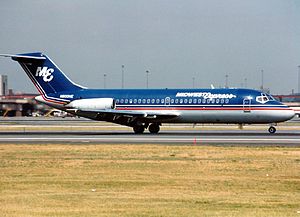
Midwest Express Airlines Flight 105
1985 aviation accident
Distance: Approx. 4433 meters
Latitude and longitude: 42.92732222,-87.90166667
Midwest Express Airlines Flight 105 was a scheduled domestic passenger flight that crashed into an open field in Oak Creek, Wisconsin shortly after taking off from General Mitchell International Airport on September 6, 1985. The airplane, a Douglas DC-9, was carrying 31 passengers and crew. None of them survived the crash.
Wisconsin's 4th congressional district
U.S. House district for Wisconsin
Distance: Approx. 5280 meters
Latitude and longitude: 42.90833333,-87.84333333
Wisconsin's 4th congressional district is a congressional district of the United States House of Representatives in Wisconsin, encompassing a part of Milwaukee County and including almost all of the city of Milwaukee (except the slivers of the city in Waukesha and Washington counties), as well as its working-class suburbs of Cudahy, St. Francis, South Milwaukee, and West Milwaukee. Recent redistricting has added the Milwaukee County North Shore communities of Glendale, Shorewood, Whitefish Bay, Fox Point, Bayside, and Brown Deer to the district.

South Milwaukee High School
Public high school in South Milwaukee, Wisconsin, United States
Distance: Approx. 4666 meters
Latitude and longitude: 42.92222222,-87.86944444
South Milwaukee High School, "Home of the Rockets," is a high school located in the city of South Milwaukee, Wisconsin, United States, a suburb of Milwaukee. Approximately 1,000 students attend the high school. The school is operated by the School District of South Milwaukee.
Oak Creek High School
Public secondary school in Oak Creek, Wisconsin, United States
Distance: Approx. 494 meters
Latitude and longitude: 42.88769,-87.90755
Oak Creek High School is a public four-year high school located in Oak Creek, Wisconsin. It is the sole high school of the Oak Creek-Franklin Joint School District, and one of the largest public schools in the state.

Painesville Chapel
United States historic place
Distance: Approx. 4442 meters
Latitude and longitude: 42.87287,-87.95216
The Painesville Chapel is a historic meeting hall built in 1852 by German immigrant Freethinkers in Franklin, Milwaukee County, Wisconsin. It was added to the National Register of Historic Places in 1977. In the 1830s and 40s, immigrants from Wittenberg, Germany were among the settlers near Franklin.

South Milwaukee Post Office
United States historic place
Distance: Approx. 4073 meters
Latitude and longitude: 42.90914,-87.86122
The South Milwaukee Post Office is a Neoclassical-styled U.S. Post office built in South Milwaukee, Wisconsin in 1931. It was added to the National Register of Historic Places in 2000.

Wisconsin Sikh temple shooting
2012 racially-motivated mass shooting in Oak Creek, Wisconsin, United States
Distance: Approx. 2411 meters
Latitude and longitude: 42.90805556,-87.91083333
The Wisconsin Sikh temple shooting was a mass shooting that took place at the gurdwara (Sikh temple) in Oak Creek, Wisconsin on August 5, 2012, when 40-year-old Wade Michael Page fatally shot six people and wounded four others. A seventh victim died of his wounds in 2020. Page committed suicide by shooting himself in the head.
Oakwood, Milwaukee County, Wisconsin
Distance: Approx. 3775 meters
Latitude and longitude: 42.85805556,-87.92444444
Oakwood was a former unincorporated area and post office in the Town of Oak Creek in Milwaukee County, Wisconsin, United States, in the area roughly corresponding to what is now Oakwood Road between South 13th Street and South Howell Avenue (sections 29-32). It had a train station with two daily stops, and was the location of Oakwood High School from 1888 to 1971. In Turner, Turner and Reinsch's 1898 Hand Book of Wisconsin: Its History and Geography ...
New Coeln, Wisconsin
Distance: Approx. 5554 meters
Latitude and longitude: 42.937,-87.91
New Coeln (also called New Cöln, New Koeln and New Köln) is a neighborhood, formerly a rural hamlet in the Town of Lake of Milwaukee County, Wisconsin, United States, but now part of Milwaukee, Wisconsin. It was settled by a group of German immigrants from the area around Cologne (German Köln) in the 1840s. By 1847, there were about fifty settlers, and a new Catholic parish, St.

South Milwaukee Passenger Station
Distance: Approx. 3994 meters
Latitude and longitude: 42.90972222,-87.86305556
The South Milwaukee Passenger Station is a historic railroad station located at 1111 Milwaukee Ave., South Milwaukee, Wisconsin. The station was built in 1893 for the Chicago & Northwestern Railway replacing a frame depot from 1885. Architect Charles Sumner Frost designed the Romanesque station.
Weather in this IP's area
overcast clouds
0 Celsius
-4 Celsius
0 Celsius
1 Celsius
1024 hPa
89 %
1024 hPa
998 hPa
10000 meters
4.12 m/s
340 degree
100 %
