209.240.173.51 - IP Lookup: Free IP Address Lookup, Postal Code Lookup, IP Location Lookup, IP ASN, Public IP
Country:
 USA
USARegion:
City:
Location:
Time Zone:
Postal Code:
ISP:
ASN:
language:
User-Agent:
Proxy IP:
Blacklist:
IP information under different IP Channel
ip-api
Country
Region
City
ASN
Time Zone
ISP
Blacklist
Proxy
Latitude
Longitude
Postal
Route
db-ip
Country
Region
City
ASN
Time Zone
ISP
Blacklist
Proxy
Latitude
Longitude
Postal
Route
IPinfo
Country
Region
City
ASN
Time Zone
ISP
Blacklist
Proxy
Latitude
Longitude
Postal
Route
IP2Location
209.240.173.51Country
usRegion
texas
City
midland
Time Zone
America/Chicago
ISP
Language
User-Agent
Latitude
Longitude
Postal
ipdata
Country
Region
City
ASN
Time Zone
ISP
Blacklist
Proxy
Latitude
Longitude
Postal
Route
Popular places and events near this IP address
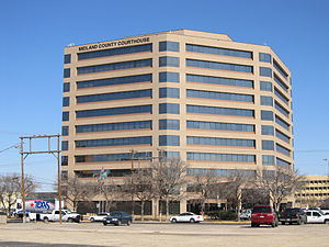
Midland County, Texas
County in Texas, United States
Distance: Approx. 9512 meters
Latitude and longitude: 31.89,-102.02
Midland County is a county located in the U.S. state of Texas. As of 2020, the population was 169,983. The county seat is Midland.

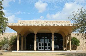
Midland International Air and Space Port
American airport and spaceport in Texas
Distance: Approx. 8751 meters
Latitude and longitude: 31.9425,-102.20194444
Midland International Air and Space Port (IATA: MAF, ICAO: KMAF, FAA LID: MAF) (formerly Midland International Airport) is in the city limits of Midland, Texas, United States, about midway between Downtown Midland and Downtown Odessa, owned and operated by the City of Midland. In September 2014, it was licensed by the Federal Aviation Administration to serve commercial spaceflight.

Momentum Bank Ballpark
Ballpark in Midland, Texas, US
Distance: Approx. 9409 meters
Latitude and longitude: 31.987332,-102.155799
Momentum Bank Ballpark (formerly First American Bank Ballpark, Citibank Ballpark, and Security Bank Ballpark) is a ballpark in Midland, Texas. It is primarily used for baseball, and is the home field of the Double-A Midland RockHounds minor league baseball team of the Texas League. Opened in 2002, the stadium holds 6,669 people with 4,709 fixed seats and the rest in berm seating.

Astound Broadband Stadium
Sports stadium in Midland, Texas, U.S.
Distance: Approx. 9397 meters
Latitude and longitude: 31.9884,-102.1522
The Astound Broadband Stadium is a 15,000-seat (18,000 capacity) stadium located in Midland, Texas. The stadium plays host to the American football and soccer teams for both Legacy High School and Midland High School, plus the West Texas FC franchise in USL League Two, which is the fourth tier of American soccer. Additionally, the West Texas Drillers adult tackle football team of the Minor Professional Football League (MPFL) as well as the West Texas Pride Minor League Football team of the Rio Grande Football League (RGFL) call the stadium home.
KZBT
Radio station in Midland, Texas
Distance: Approx. 7276 meters
Latitude and longitude: 31.958,-102.067
KZBT (93.3 FM, "B93") is a rhythmic contemporary radio station serving the Midland-Odessa region. The station is owned by Townsquare Media, and its studios are located on Highway 191 just west of Midland (its city of license) in rural Midland County. The station's transmitter is located just south of Midland.

KMND
Radio station in Midland, Texas
Distance: Approx. 6989 meters
Latitude and longitude: 31.96361111,-102.08138889
KMND (1510 AM), branded as "Fox Sports 1510 KMND", is a radio station that serves the Midland–Odessa metropolitan area with Fox Sports Radio talk shows, the WinningEDGE radio show, and a weekly sports update on Pro Football and Basketball. It also simulcasts the programming on 99.5 FM. 1510 AM is under ownership of Townsquare Media. 99.5 FM is owned by Eastern New Mexico University under a LMA to Townsquare Media.
Premier High School of Midland
Distance: Approx. 9653 meters
Latitude and longitude: 31.994791,-102.102438
Premier High School of Midland is a charter school in Midland, Texas that serves students in ninth grade through twelfth grade. It is part of Responsive Education Solutions of Texas.
KLPF
Radio station in Midland, Texas
Distance: Approx. 7658 meters
Latitude and longitude: 31.93388889,-102.0425
KLPF (1180 AM) is a radio station broadcasting a Christian radio format. It is the flagship station of the Guadalupe Radio Network, which provides Catholic religious radio programming to several radio stations in the United States. Licensed to Midland, Texas, United States.
KACD-LP
Radio station in Midland, Texas
Distance: Approx. 9253 meters
Latitude and longitude: 31.99055556,-102.09861111
KACD-LP (94.1 FM) is a low-power FM radio station licensed to Midland, Texas, United States, serving the Odessa-Midland area. The station is currently owned by Helping Others Prepare for Empowerment (HOPE). The station went silent on May 26, 2020.
Permian Basin Petroleum Museum
Museum in Midland, Texas, USA
Distance: Approx. 7698 meters
Latitude and longitude: 31.9724,-102.0853
The Permian Basin Petroleum Museum is a museum in Midland, Texas, USA, with exhibits relating to the oil and gas industry of the Permian Basin of west Texas and southeast New Mexico. Museum exhibits include the geology of the area during the Permian period, the technology of the petroleum industry, racing cars designed by Jim Hall, and paintings by artist Tom Lovell. The museum was founded in 1975.
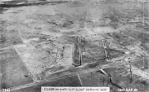
Midland Army Airfield
Airport in Midland, Texas
Distance: Approx. 9075 meters
Latitude and longitude: 31.94333333,-102.20527778
Midland Army Airfield is a former World War II military airfield, located 8.4 miles west-southwest of Midland, Texas. It operated as a Bombardier training school for the United States Army Air Forces from 1942 until 1945.
Midland train crash
2012 railroad accident in Texas, US
Distance: Approx. 8831 meters
Latitude and longitude: 31.985629,-102.093495
The Midland train crash was a rail crossing accident that occurred on November 15, 2012 in Midland, Texas. A freight train struck a flatbed trailer being used as a parade float carrying 26 passengers (12 of them United States Armed Forces veterans who had been wounded in action), killing four and injuring 16. The parade was en route to a veterans' benefit sponsored by the local charity Show of Support/Hunt for Heroes.
Weather in this IP's area
fog
12 Celsius
12 Celsius
11 Celsius
13 Celsius
1013 hPa
94 %
1013 hPa
915 hPa
402 meters
3.09 m/s
240 degree
100 %