209.240.171.12 - IP Lookup: Free IP Address Lookup, Postal Code Lookup, IP Location Lookup, IP ASN, Public IP
Country:
 USA
USARegion:
City:
Location:
Time Zone:
Postal Code:
ISP:
ASN:
language:
User-Agent:
Proxy IP:
Blacklist:
IP information under different IP Channel
ip-api
Country
Region
City
ASN
Time Zone
ISP
Blacklist
Proxy
Latitude
Longitude
Postal
Route
db-ip
Country
Region
City
ASN
Time Zone
ISP
Blacklist
Proxy
Latitude
Longitude
Postal
Route
IPinfo
Country
Region
City
ASN
Time Zone
ISP
Blacklist
Proxy
Latitude
Longitude
Postal
Route
IP2Location
209.240.171.12Country
usRegion
texas
City
big spring
Time Zone
America/Chicago
ISP
Language
User-Agent
Latitude
Longitude
Postal
ipdata
Country
Region
City
ASN
Time Zone
ISP
Blacklist
Proxy
Latitude
Longitude
Postal
Route
Popular places and events near this IP address

Howard College
Community college in Big Spring, Texas, US
Distance: Approx. 683 meters
Latitude and longitude: 32.2506,-101.4511
Howard College is a public community college with its main campus in Big Spring, Texas. It also has branch campuses in San Angelo and Lamesa.

Big Spring Vietnam Memorial
Distance: Approx. 4375 meters
Latitude and longitude: 32.229272,-101.498389
The Big Spring Vietnam Memorial is a war memorial located in Big Spring, Texas, United States, honoring American servicemen (especially those local to Big Spring) who gave their lives, became prisoners of war or went missing in action in the Vietnam War. Dedicated May 27, 1991, the black granite memorial monument measures 9.5 feet (2.9 m) by 6 feet (1.8 m) by 6 feet (1.8 m),a map of Vietnam, and a POW-MIA logo. The 2-acre (8,100 m2) park surrounding the memorial also contains a UH-1 "Huey" MEDEVAC helicopter, an F-4E Phantom II fighter jet, an AH-1 Cobra attack helicopter, and a M60 Patton tank.

Big Spring State Park (Texas)
State park in Texas, United States
Distance: Approx. 3572 meters
Latitude and longitude: 32.23222222,-101.49055556
Big Spring State Park is a Texas state park in Big Spring, Howard County, Texas in the United States. It was opened in 1936 after the 381.99 acres (154.59 ha) upon which it is situated was deeded to the state by the city of Big Spring in 1934 and 1935. It is named for the natural spring once located on the site that was later replaced by an artificial one.
Big Spring Independent School District
School district in Texas
Distance: Approx. 721 meters
Latitude and longitude: 32.24606,-101.464991
Big Spring Independent School District is a public school district based in Big Spring, Texas (USA).
Elbow Creek Wind Project
Distance: Approx. 4457 meters
Latitude and longitude: 32.21585278,-101.43093056
The Elbow Creek Wind Project was a 122 megawatt (MW) wind farm beginning in 2008 in Howard County near Big Spring, Texas. The project used 53 Siemens 2.3 MW wind turbine generators, which provide enough electricity for nearly 100,000 households. It was repowered in 2019.

Settles Hotel
Hotel in Big Spring, Texas
Distance: Approx. 1689 meters
Latitude and longitude: 32.25277778,-101.47527778
The Hotel Settles is a historic 15-story hotel located at 200 East Third Street in Big Spring, Texas. Originally completed in 1930, the Settles opened for business October 1, 1930. It operated from 1930 until the early 1980s, and was subsequently abandoned for around 30 years, before reopening in late 2012.

KBST (AM)
Radio station in Big Spring, Texas
Distance: Approx. 1520 meters
Latitude and longitude: 32.26222222,-101.46027778
KBST (1490 AM) is a radio station broadcasting a news-talk format. Licensed to Big Spring, Texas, United States, the station serves the Big Spring-Snyder area. The station is currently owned by Kbest Media, LLC, and includes programming from ABC News Radio, Fox Sports Radio, Compass Media Networks, Premiere Networks, and Westwood One.
KBTS
Radio station in Big Spring, Texas
Distance: Approx. 3577 meters
Latitude and longitude: 32.22027778,-101.44027778
KBTS (94.3 FM, "The Fuse") is a radio station licensed to serve Big Spring, Texas, United States. The station is currently owned by Kbest Media, LLC. KBTS broadcasts a hot adult contemporary music format to the greater Big Spring-Snyder, Texas, area. The station was assigned the KBTS call sign by the Federal Communications Commission on August 6, 1993.

KBYG
Radio station in Big Spring, Texas
Distance: Approx. 3365 meters
Latitude and longitude: 32.22277778,-101.47638889
KBYG (1400 AM, "Big 1400 AM") is a radio station broadcasting a classic hits music format. Licensed to Big Spring, in the U.S. state of Texas, the station serves the Big Spring-Snyder area. The station is currently owned by Weeks Broadcasting, Inc.

Federal Correctional Institution, Big Spring
Federal prison in Big Spring, Texas
Distance: Approx. 5013 meters
Latitude and longitude: 32.22851,-101.50559
The Federal Correctional Institution, Big Spring (FCI Big Spring) is a low-security United States federal prison for male inmates in Texas. It is operated by the Federal Bureau of Prisons, a division of the United States Department of Justice. The facility also has a satellite prison camp which houses minimum-security male offenders.

Potton–Hayden House
Historic house in Texas, United States
Distance: Approx. 1920 meters
Latitude and longitude: 32.25,-101.47833333
The Potton–Hayden House is a historic house in Big Spring, Texas, USA. It was built in 1901. It has been listed on the National Register of Historic Places since April 14, 1975. The house is owned by the Heritage Museum of Big Spring and open for tours by appointment.
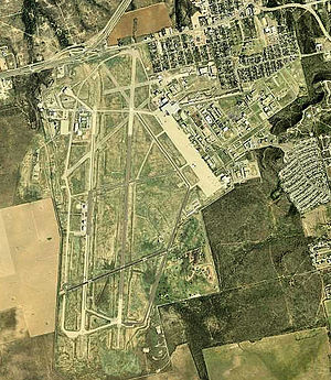
Webb Air Force Base
Near Big Spring, Texas
Distance: Approx. 6875 meters
Latitude and longitude: 32.21805556,-101.52138889
Webb Air Force Base (IATA: BGS), previously named Big Spring Air Force Base, was a United States Air Force facility of the Air Training Command that operated from 1951 to 1977 in West Texas within the current city limits of Big Spring. Webb AFB was a major undergraduate pilot training (UPT) facility for the Air Force, and by 1969, almost 9,000 pilots had been trained at Webb. The last operational wing at Webb AFB was the 78th Flying Training Wing.
Weather in this IP's area
fog
14 Celsius
14 Celsius
12 Celsius
14 Celsius
1013 hPa
90 %
1013 hPa
924 hPa
805 meters
3.58 m/s
6.26 m/s
224 degree
75 %